
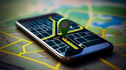
Scientists are testing an alternative to the global positioning system (GPS), using mobile signals as an emergency backup in case an aircraft's GPS signal is jammed or interrupted.

The new system can capture signals from cell towers from an altitude of 24,300m - Photo: Sandia National Laboratories
The project, conducted by researchers at Sandia National Laboratories and Ohio State University (USA), aims to create a safety net for airborne navigation systems.
According to LiveScience on November 26, the research team used receivers suspended in the air to detect radio waves from communication satellites and cell towers related to the aircraft. Then used this information to provide navigation data to pilots.
The team strapped antenna systems to weather balloons and launched them into the stratosphere (at altitudes of 6-50km above the ground) in a position between satellites and cell towers to detect their individual signals.
Theoretically, this antenna system could act as an emergency beacon if the pilot lost the GPS signal.
Although GPS is highly accurate, it is not without its flaws. GPS signals can be deliberately jammed in and around war zones. Hackers can also “spoof” GPS signals to send false information about a pilot’s location or direction.
Additionally, GPS systems can malfunction or stop altogether. People could be put at risk if a commercial aircraft lost its GPS signal. That's why the group believes a backup system is essential.
Currently, the team still has to manually determine which satellite is sending which signal based on available reference data. In the future, the team hopes to create algorithms that allow antenna systems to automatically identify satellites and use satellite and cell tower data to determine a person's location and velocity in real time.
Previous tests of the technology have been limited to altitudes of 1,500 to 2,000 metres. However, the team’s new project takes the antenna system to an altitude of 24,300 metres. If the system can send back reliable navigation data from this height, it could have real benefits for air travel.
While the system hovers at an altitude of 80,000 feet to get better signals from both communications satellites above and cell towers on the ground, it’s not a perfect method. Satellites focus radio waves down toward Earth for optimal ground-level reception, so a strong signal isn’t guaranteed at all times at the altitude of a weather balloon.
Therefore, the team needs to improve detection capabilities and speed to account for the possibility of this error occurring in the future.
Source: https://tuoitre.vn/phat-trien-he-thong-moi-co-the-thay-the-gps-20241126113215133.htm

![[Photo] Prime Minister Pham Minh Chinh receives Swedish Minister of International Development Cooperation and Foreign Trade](https://vphoto.vietnam.vn/thumb/1200x675/vietnam/resource/IMAGE/2025/5/12/ae50d0bb57584fd1bbe1cd77d9ad6d97)


![[Photo] Prime Minister Pham Minh Chinh starts construction of vital highway through Thai Binh and Nam Dinh](https://vphoto.vietnam.vn/thumb/1200x675/vietnam/resource/IMAGE/2025/5/12/52d98584ccea4c8dbf7c7f7484433af5)
![[Photo] Prime Minister Pham Minh Chinh works with the Standing Committee of Thai Binh Provincial Party Committee](https://vphoto.vietnam.vn/thumb/1200x675/vietnam/resource/IMAGE/2025/5/12/f514ab990c544e05a446f77bba59c7d1)


Comment (0)