

The "best" in the district with the largest area in the country
With an area of over 2,811 square kilometers, Tuong Duong is the largest district in Nghe An province and also the largest district-level unit in the country.
According to data from the General Statistics Office, Tuong Duong district covers an area larger than 20 provinces and cities nationwide, including: Bac Ninh, Hai Phong, Hai Duong, Hung Yen, Thai Binh, Vinh Phuc, Nam Dinh, Ha Nam, Ninh Binh, Da Nang city, Binh Duong, Ba Ria - Vung Tau, Ho Chi Minh City, Vinh Long, Hau Giang, Bac Lieu, Tien Giang, Ben Tre, Tra Vinh and Can Tho city.

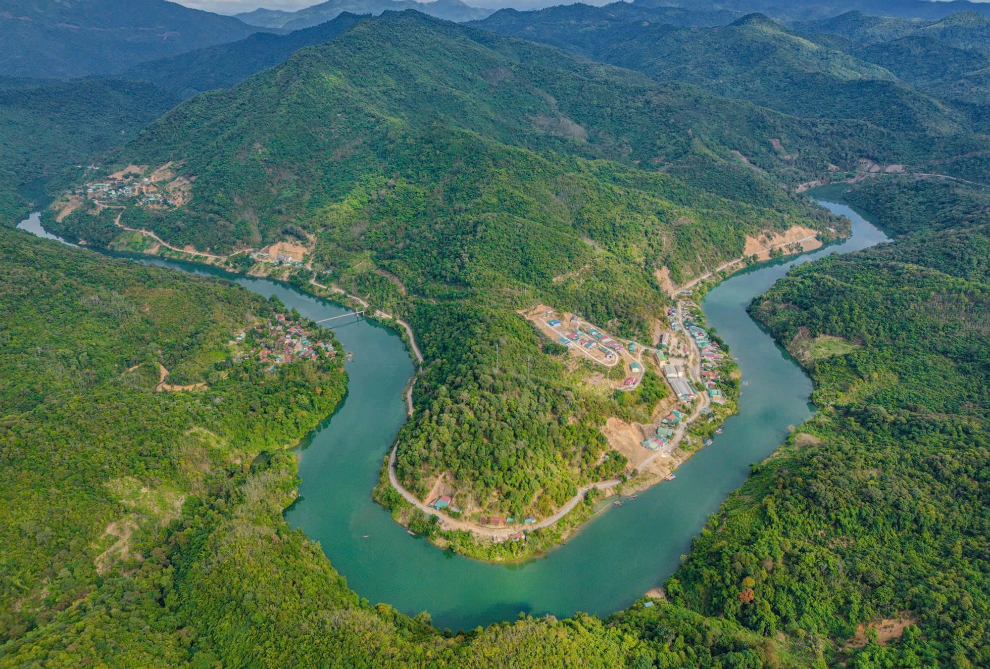
Thach Giam town, center of Tuong Duong district, seen from above (Photo: Luong Kien).
The area of Tuong Duong district is even larger than the three provinces of Hung Yen (930.20km2), Ha Nam (860.90km2) and Bac Ninh (822.70km2) combined and is 3.4 times larger than the smallest province in Vietnam, Bac Ninh.
From Vinh city (Nghe An), going up National Highway 7, Tuong Duong district welcomes visitors with a picturesque cassia forest. The forest with tall, straight trees, covering 70 hectares in Tam Dinh commune (Tuong Duong) is considered the most beautiful cassia forest in Indochina. Services have been established here to serve tourists with the hope of turning the cassia forest into a tourist highlight of this border district.
Along with the western mountainous districts of Nghe An province, Tuong Duong is located in the core zone of the largest biosphere reserve in Southeast Asia. Tuong Duong forest is particularly rich in species with primeval forests over 1,000 years old, many of which have been listed in the Vietnam Red Book.
At the end of February, passing through the cajuput forest and reaching the town of Thach Giam, there was a different type of weather that made the tourists from Vinh city with thick warm clothes unable to cope. In the passionate yellow sunlight, the brilliant white flowers bloomed, covering the streets and office premises.

The Sang Le forest in Tam Dinh commune, Tuong Duong district is an attractive destination for tourists when coming to this border district (Photo: Ho Phuong).
Tuong Duong is the source of the Ca River, located in the largest biosphere reserve in Southeast Asia, with a dense system of rivers and streams... but that is not enough to dispel the heat that has become the "trademark" of this land with a history of 555 years.
"Tuong Duong is known as the "fire pan of Indochina", the dry season comes earlier and the average temperature in summer is always higher than other localities in the province. In summer, the temperature measured here can reach 41-42 degrees Celsius, combined with the Lao wind, the feeling of heat increases many times", Mr. Vo Dinh Tuan, residing in Thach Giam town shared.
In the midst of the "fire pan of Indochina", the only thing that can help people cope with the harsh sunlight is probably air conditioners or electric fans running at full capacity.
Electricity from Ban Ve Hydropower Plant (Yen Na Commune, Tuong Duong) with an annual output of nearly 1,100 million kWh, not only "quenched the thirst" for electricity for this district and other localities in the country, but also provided part of the electricity to neighboring Laos.
With a basin area of 8,700km2, Ban Ve is also the largest hydroelectric project in the North Central region, providing water for daily life, production, saltwater intrusion, and flood control for the downstream of the Ca River...

Ban Ve Hydropower Plant is the largest hydropower project in the North Central region (Photo: Luong Kien).
Despite many special things like that, Tuong Duong is still a poor district of Nghe An province and one of the 62 poorest districts in the country.
Many "bottlenecks" in economic and social development
In 2024, the total production value in Tuong Duong district is estimated to reach 6,193 billion VND, with a growth rate of 7.7%, and an average income per capita of 38.4 million VND. Despite the efforts and determination of the entire political system, this result is still quite modest.
According to Mr. Nguyen Huu Hien, Vice Chairman of the People's Committee of Tuong Duong district, as the largest district in the country, the locality has many potentials and advantages but also faces many difficulties and challenges in economic and social development...
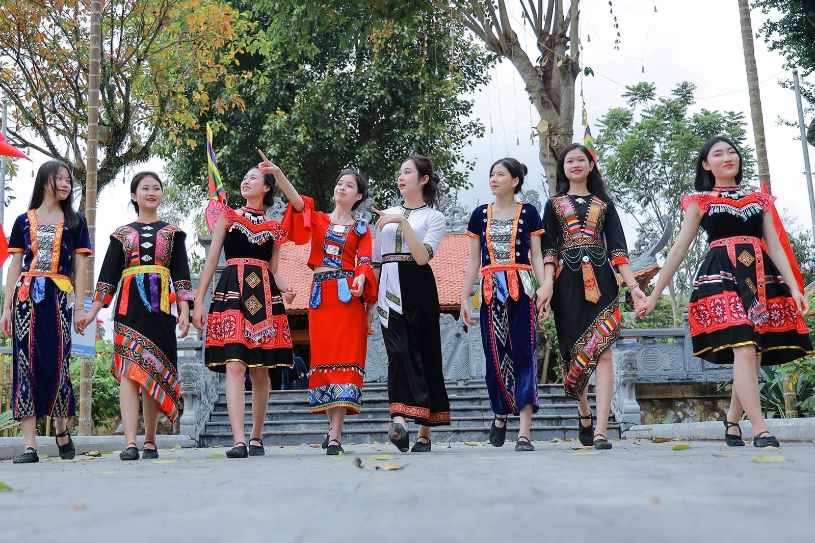
Ethnic people of Tuong Duong district in traditional costumes (Photo: Dinh Tuan).
Mr. Hien said that Tuong Duong has up to 93% of its area as natural forests and forestry land. Flat land and agricultural land account for a very small proportion, and are fragmented, making it difficult to plan production. In addition, as a border district, far from the provincial center, Tuong Duong faces many difficulties in attracting businesses to invest.
Although the district has a large area but a population of only over 83,000 people, according to Mr. Hien, Tuong Duong is also one of the localities with the lowest population density in the country. 90% of the population of Tuong Duong district are ethnic minorities.
Mr. Hien added that the whole district has 6 ethnic groups living together, including 2 ethnic groups with particularly small populations, the O Du and Tay Poong, whose cultural level as well as the ability to access advances in science and technology and apply them to production are still limited.
By the end of 2024, the poverty rate in this locality will reach 25.3%, 6 times higher than the provincial average.
With high mountainous terrain, Tuong Duong district is also divided by three large rivers: Nam Non, Nam Mo and Ca rivers (Photo: Luong Kien).
"Tuong Duong is a mountainous district with a wide and fragmented terrain. Infrastructure, especially traffic infrastructure, is still very difficult. Up to now, Huu Khuong commune still does not have a smooth traffic route from the district center to the commune.
This is also the most remote and difficult commune in the district. To get there, it takes more than 3 hours to travel by road and waterway through Ban Ve hydroelectric reservoir," Mr. Hien informed.
Tuong Duong district borders Con Cuong, Ky Son, Que Phong districts (Nghe An), with a 57.93km long border with Laos. Currently, this locality has 17 commune-level administrative units, including 1 town and 16 communes with 6 ethnic groups living together, including: Thai, Kinh, Kho Mu, Mong, O Du, Tay Poong.
Dantri.com.vn


![[Photo] Vietnam and Sri Lanka sign cooperation agreements in many important fields](https://vphoto.vietnam.vn/thumb/1200x675/vietnam/resource/IMAGE/2025/5/5/9d5c9d2cb45e413c91a4b4067947b8c8)


![[Photo] President Luong Cuong presided over the welcoming ceremony and held talks with Sri Lankan President Anura Kumara Dissanayaka](https://vphoto.vietnam.vn/thumb/402x226/vietnam/resource/IMAGE/2025/5/5/351b51d72a67458dbd73485caefb7dfb)


![[Photo] President Luong Cuong and Sri Lankan President Anura Kumara Dissanayaka visit President Ho Chi Minh relic site](https://vphoto.vietnam.vn/thumb/1200x675/vietnam/resource/IMAGE/2025/5/5/0ff75a6ffec545cf8f9538e2c1f7f87a)


Comment (0)