
Latest update on storm MANYI, according to the National Center for Hydro-Meteorological Forecasting, super storm MANYI is in the sea east of the central Philippines, reaching level 16 (184-201km/h), gusting above level 17 - super storm level.
Update the latest news on storm MANYI
At 01:00 on November 17, the center of super typhoon MANYI was at about 14.3 degrees North latitude; 123.8 degrees East longitude, in the sea east of the central Philippines. The strongest wind near the center of the super typhoon was level 16 (184-201 km/h), gusting over level 17. Moving northwest at a speed of 20 km/h.
It is expected that tomorrow, November 18, super typhoon MANYI will enter the East Sea and gradually weaken but still reach level 13, gusting to level 15.
As of November 19, storm MANYI is about 490km northeast of Hoang Sa archipelago, at this time the storm is at level 11, gusting to level 13.
Storm forecast ( next 24 to 72 hours):
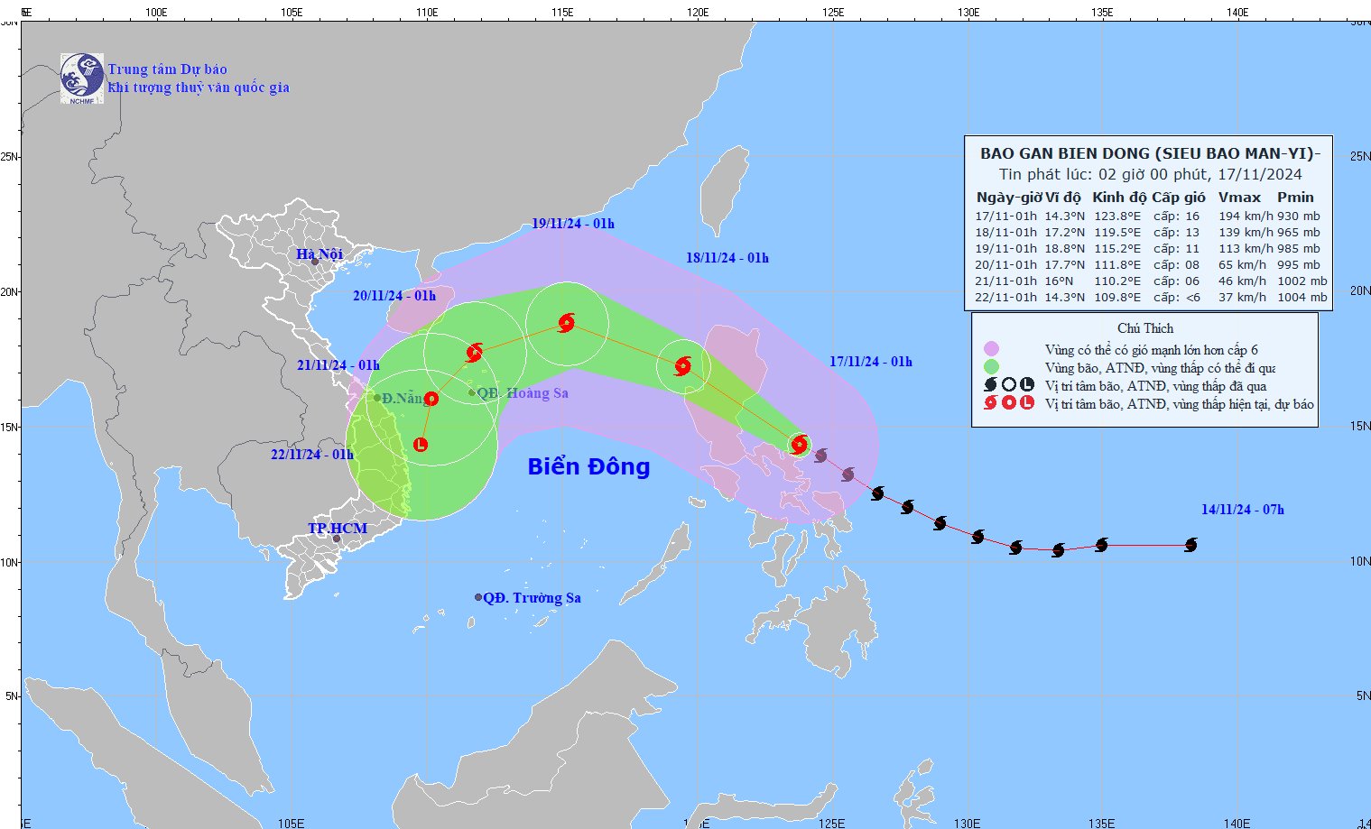
The movement of super typhoon MANYI. Photo: nchmf.
Forecast time | Direction, speed | Location | Intensity | Danger zone | Disaster Risk Level (Affected Area) |
01h/18/11 | Northwest, about 20km/h, entering the East Sea and gradually weakening | 17.2N-119.5E; in the eastern sea of the North East Sea area | Level 13, jerk level 15 | Latitude 14.0N-19.0N; East of longitude 118.0E | Level 3: East of the North East Sea area |
01h/19/11 | Northwest, 20-25km/h, continuing to weaken | 18.8N-115.2E; in the North East Sea area; about 490km northeast of Hoang Sa archipelago | Level 11, jerk level 13 | Latitude 15.0N-21.0N; East of longitude 115.5E | Level 3: North East Sea area |
01h/20/11 | West Northwest about 15km/h | 17.7N-111.8E; in the North East Sea area, about 160km north of Hoang Sa archipelago | Level 8, level 10 jerk | Latitude 15.0N-20.5N; East of longitude 109.5E | Level 3: North East Sea area |
From the next 72 to 120 hours, the storm moved in a southwest direction, traveling 10km per hour, and continued to weaken.
Warning of the impact of super typhoon MANYI
From the afternoon of November 17, the sea area east of the North East Sea has strong winds of level 6-7, then increasing to level 8-9, near the storm center, level 11-13, gusting to level 16, waves 2.0-4.0m high, near the storm center 5.0-7.0m; rough seas.
Ships operating in the above mentioned dangerous areas are likely to be affected by storms, whirlwinds, strong winds and large waves.
How does cold air affect super typhoon MANYI?
Meanwhile, according to the National Center for Hydro-Meteorological Forecasting, the cold air mass is currently moving south.
Around the afternoon and night of November 17, this cold air mass will affect the Northeast; then affect the North Central region, some places in the Northwest and the Central Central region. The Northeast wind inland will strengthen to level 3, coastal areas level 4.
From November 18, in the Northeast and Thanh Hoa, the weather will turn cold at night and early morning; from November 20, in the North and North Central regions, the weather will be cold at night and early morning. The lowest temperature during this cold air mass in the North and North Central regions will generally be from 18-20 degrees Celsius, in mountainous areas, some places will be below 15 degrees Celsius.
At sea: from November 18, in the Gulf of Tonkin, the Northeast wind will gradually increase to level 6, gusting to level 7-8; rough seas; waves from 2.0-4.0m high. In the North East Sea, the Northeast wind will increase to level 6-7, gusting to level 8-9; rough seas; waves from 3.0-5.0m high.
Due to the influence of disturbances in the upper easterly wind zone combined with cold air, from November 18-19, in the North and Central Central regions, there will be scattered showers and thunderstorms, with some places having heavy rain. During thunderstorms, there is a possibility of tornadoes, lightning and strong gusts of wind.
Mr. Nguyen Van Huong, Head of Weather Forecasting Department, National Center for Hydro-Meteorological Forecasting, said that cold air will cause super typhoon MANYI to weaken when entering the East Sea. However, it will make the weather in the East Sea area very bad in the coming days, with strong winds, high waves, rough seas and the development of this typhoon MAN-YI will have many changes, requiring close monitoring.
Source: https://danviet.vn/tin-bao-moi-nhat-ngay-mai-18-11-sieu-bao-manyi-vao-bien-dong-gap-khong-khi-lanh-se-nguy-hiem-the-nao-2024111705301082.htm


![[Photo] Prime Minister Pham Minh Chinh receives Swedish Minister of International Development Cooperation and Foreign Trade](https://vphoto.vietnam.vn/thumb/1200x675/vietnam/resource/IMAGE/2025/5/12/ae50d0bb57584fd1bbe1cd77d9ad6d97)
![[Photo] Prime Minister Pham Minh Chinh starts construction of vital highway through Thai Binh and Nam Dinh](https://vphoto.vietnam.vn/thumb/1200x675/vietnam/resource/IMAGE/2025/5/12/52d98584ccea4c8dbf7c7f7484433af5)
![[Photo] Prime Minister Pham Minh Chinh works with the Standing Committee of Thai Binh Provincial Party Committee](https://vphoto.vietnam.vn/thumb/1200x675/vietnam/resource/IMAGE/2025/5/12/f514ab990c544e05a446f77bba59c7d1)


Comment (0)