 |
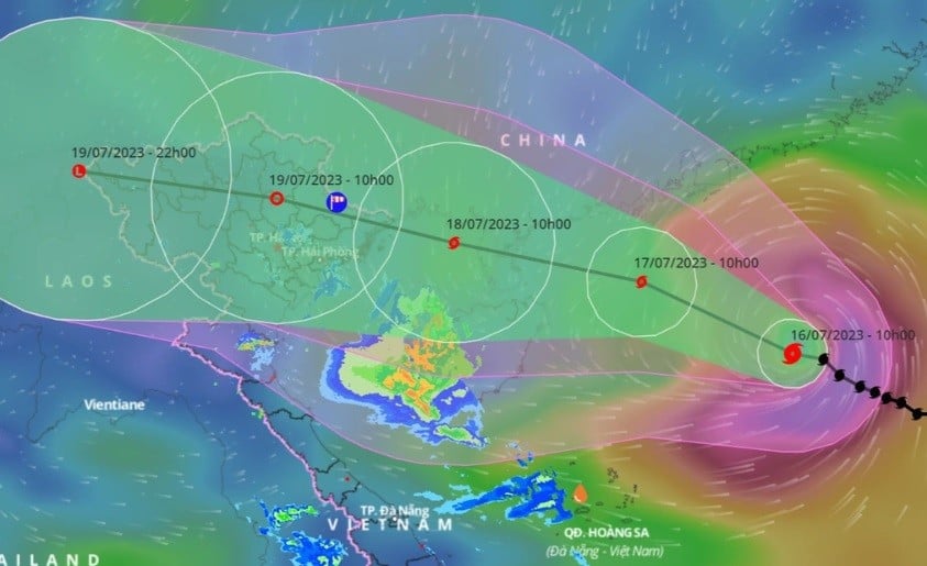
| The forecast path of storm No. 1 is likely to head towards the Gulf of Tonkin and cause heavy rain in the North. (Source: VNDMS) |
At noon on July 16, the National Center for Hydro-Meteorological Forecasting said that storm No. 1 maintained strong winds of level 9-10 (75-102km/h), gusting to level 13. At 10am, the storm's center was located about 610km east-southeast of Leizhou Peninsula (China).
Mr. Nguyen Van Huong, Head of Weather Forecasting Department, said that in the next 24-48 hours, storm No. 1 will move west-northwest at a speed of 15km/h and is likely to strengthen.
On the evening and night of July 17, the storm is likely to make landfall in the northern area of Leizhou Peninsula (China). After this time, the storm will move west-northwest down to the Gulf of Tonkin and directly affect the mainland of Vietnam around the afternoon and night of July 18.
According to Mr. Huong, this is a relatively unified scenario of the International and Vietnamese Forecasting Centers.
However, experts note that there is a possibility that storm No. 1, when passing over the Leizhou Island area (China), may change direction to move further south and expand the area of influence to the southern provinces of the Northern Delta and Thanh Hoa. This scenario has a low probability but still needs to be taken into account.
The focus of rain due to storms in the North is July 18.
Regarding the impact of the storm on the mainland, the meteorological agency said that long-term forecasts are still likely to occur. Initial assessments show that the storm is likely to cause strong winds in many coastal areas. This could be the strongest storm to affect the North in recent years.
In addition, even when the storm is still far out at sea, thunderstorms, tornadoes, and lightning may appear on the mainland at the far edge of the storm. People should pay special attention to heavy rain and strong winds on land from dawn on July 18 to July 21. The focus of rain will be on the day and night of July 18.
Experts also warned that heavy rains occurring after many consecutive days of thunderstorms and hot weather will increase the risk of flash floods and landslides in the North from July 18. The provinces that need to be on guard are Lang Son, Cao Bang, Ha Giang, Lao Cai, and Yen Bai.
"It is very difficult to accurately warn of specific locations of landslides, so it is recommended that the National Steering Committee for Natural Disaster Prevention direct local emergency forces to regularly check vulnerable areas at risk of landslides in the area to notify households to take note and take precautions," according to the meteorological agency.
Under the influence of the storm circulation, the northern area of the northern sea of the North East Sea may have strong winds of level 11-12, gusting to level 15. Waves are 6-8m high, and the sea is very rough.
The southern sea area of the North East Sea, the central and southern East Sea area (including the sea area of Hoang Sa and Truong Sa archipelagos) and the sea area from Ninh Thuan to Ca Mau has strong southwest wind level 6, sometimes level 7, gusting to level 8-9. Waves are 2.5-5m high, rough seas.
The northern Gulf of Tonkin (including Co To and Bach Long Vi island districts) will have strong storm winds from the afternoon and evening of July 17. Beware of the risk of big waves in coastal areas from Quang Ninh to Ninh Binh provinces.
Ships need to stay in touch regularly and update forecasts to proactively avoid and take shelter. Coastal areas need to pay attention to tourist boats, storm shelters, and aquaculture areas.
Source


![[Photo] President Luong Cuong attends the inauguration of the international container port in Hai Phong](https://vphoto.vietnam.vn/thumb/1200x675/vietnam/resource/IMAGE/2025/5/13/9544c01a03e241fdadb6f9708e1c0b65)

![[Photo] Prime Minister Pham Minh Chinh receives Ambassador of the French Republic to Vietnam Olivier Brochet](https://vphoto.vietnam.vn/thumb/1200x675/vietnam/resource/IMAGE/2025/5/13/f5441496fa4a456abf47c8c747d2fe92)

![[Photo] Prime Minister Pham Minh Chinh meets with US business representatives](https://vphoto.vietnam.vn/thumb/1200x675/vietnam/resource/IMAGE/2025/5/13/5bf2bff8977041adab2baf9944e547b5)


![[Video] Promoting digital transformation, improving training efficiency](https://vphoto.vietnam.vn/thumb/402x226/vietnam/resource/IMAGE/2025/5/13/5e9d4dbe34b74d3a8d0d6d7fb23d4dcb)


Comment (0)