
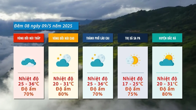
Heavy rain is forecast to concentrate in Bac Ha, Muong Khuong, Van Ban, Bat Xat, Bao Thang districts, Sa Pa town and Lao Cai city. There is a risk of flash floods and landslides in some highland areas of the above localities.
According to the National Center for Hydro-Meteorological Forecasting, the North is currently affected by a low pressure trough with an axis at about 25 - 26 degrees North latitude moving south, combined with the impact of the high-altitude wind convergence zone formed later, creating a combination of bad weather causing widespread thunderstorms.
Accordingly, from tonight (May 28) onwards, Lao Cai will have scattered showers and thunderstorms. By the evening and night of May 29, the amount of rain in some localities will increase. This rain is likely to last for 3 days, with some days having scattered moderate rain and some places having heavy rain. Rainfall in some areas is from 40 - 80 mm/period, with some places having over 120 mm/period.
Therefore, people living along streams, small streams with steep slopes, places with basin-shaped terrain, paper fan-shaped terrain, areas where flash floods or landslides often occur, especially localities that have been warned, need to strengthen the highest level of disaster prevention and control work; beware of prolonged heavy rain causing high floods, flash floods, landslides. Do not be subjective, neglect tornadoes, hail, lightning, strong gusts of wind when there are thunderstorms.
Low-lying areas, river and stream confluences; low-lying areas in towns, cities, and cities are protected from heavy rain during periods of deep flooding.
Source
![[Photo] General Secretary concludes visit to Azerbaijan, departs for visit to Russian Federation](https://vphoto.vietnam.vn/thumb/1200x675/vietnam/resource/IMAGE/2025/5/8/7a135ad280314b66917ad278ce0e26fa)
![[Photo] National Assembly Chairman Tran Thanh Man chairs the meeting of the Subcommittee on Documents of the First National Assembly Party Congress](https://vphoto.vietnam.vn/thumb/1200x675/vietnam/resource/IMAGE/2025/5/8/72b19a73d94a4affab411fd8c87f4f8d)
![[Photo] Prime Minister Pham Minh Chinh meets with the Policy Advisory Council on Private Economic Development](https://vphoto.vietnam.vn/thumb/1200x675/vietnam/resource/IMAGE/2025/5/8/387da60b85cc489ab2aed8442fc3b14a)

![[Photo] President Luong Cuong presents the decision to appoint Deputy Head of the Office of the President](https://vphoto.vietnam.vn/thumb/1200x675/vietnam/resource/IMAGE/2025/5/8/501f8ee192f3476ab9f7579c57b423ad)
![[Photo] General Secretary To Lam begins official visit to Russia and attends the 80th Anniversary of Victory over Fascism](https://vphoto.vietnam.vn/thumb/1200x675/vietnam/resource/IMAGE/2025/5/8/5d2566d7f67d4a1e9b88bc677831ec9d)


![[Infographic] Instructions on steps to contribute ideas to amend the 2013 Constitution on VNeID](https://vphoto.vietnam.vn/thumb/402x226/vietnam/resource/IMAGE/2025/5/8/c61c8c11815c4691848ae93a3e567ef7)


![[Photo] Prime Minister Pham Minh Chinh talks on the phone with Singaporean Prime Minister Lawrence Wong](https://vphoto.vietnam.vn/thumb/402x226/vietnam/resource/IMAGE/2025/5/8/e2eab082d9bc4fc4a360b28fa0ab94de)


Comment (0)