
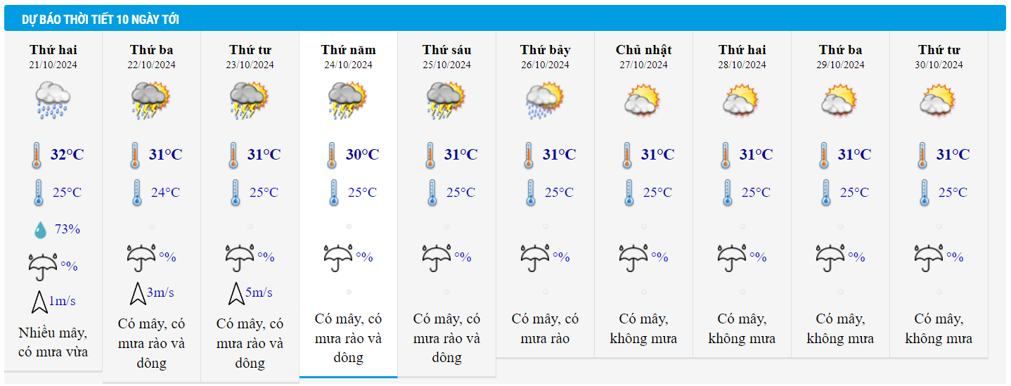
Weather forecast for October 21, 2024, the Northern region will have showers and thunderstorms in some places; in the East, there will be very heavy rain in some places. Hanoi will have rain, light wind, highest temperature 28-30 degrees.
According to the National Center for Hydro-Meteorological Forecasting, currently, in the northeastern sea area of the North East Sea, there are strong northeast winds of level 6, sometimes level 7.
In the western sea area of the North East Sea (including the sea area of Hoang Sa archipelago), the central and southern East Sea area (including the sea area of Truong Sa archipelago), the sea area from Quang Tri to Quang Ngai, Binh Thuan to Ca Mau, Ca Mau to Kien Giang and the Gulf of Thailand, there will be scattered showers and thunderstorms.
Forecast tonight and October 21, the North East Sea area (including the waters of Hoang Sa archipelago) will have strong Northeast wind level 6, in the East at times level 7, gusting to level 8-9; rough seas, waves 3-5m high.
The western sea area of the North East Sea (including the Hoang Sa archipelago), the central and southern East Sea area (including the Truong Sa archipelago), the southern area of the Gulf of Tonkin, the sea area from Quang Tri to Quang Ngai, Binh Thuan to Ca Mau , Ca Mau to Kien Giang and the Gulf of Thailand will have scattered showers and thunderstorms. During thunderstorms, there is a possibility of tornadoes and strong gusts of wind of level 7-8.
All vessels operating in the above areas are at high risk of being affected by cyclones, strong winds and large waves.
In addition, experts from the National Center for Hydro-Meteorological Forecasting said that there is currently a cold air mass moving eastward, which will strengthen from October 22 to 23, then stabilize and weaken slowly.
From the night of October 21, a tropical convergence zone will form with an axis at about 9-12 degrees North latitude. On this tropical convergence zone, there is a possibility of forming a tropical cyclone.
On land, the weather forecast for October 21 is as follows:
The Northern region has scattered showers and thunderstorms; the Eastern region has scattered showers and thunderstorms, with some places experiencing very heavy rain.
The area from Thanh Hoa to Binh Dinh has moderate rain, heavy rain and scattered thunderstorms, locally very heavy rain.
Other areas have scattered showers and thunderstorms; in the afternoon and evening there are scattered showers and thunderstorms, with some heavy rain in some places.
Thunderstorms may cause tornadoes, lightning and strong gusts of wind.

Detailed weather forecast for tonight and October 21, 2024 for regions across the country:
Hanoi
Cloudy with occasional showers, moderate showers and thunderstorms. Light winds. Thunderstorms with possibility of tornadoes, lightning and strong gusts of wind.
Lowest temperature: 23-25 degrees.
Highest temperature: 28-30 degrees.
Northwest
Partly cloudy with scattered showers and thunderstorms. Light winds. Thunderstorms may produce tornadoes, lightning and strong gusts of wind.
Lowest temperature: 22-25 degrees, some places below 21 degrees.
Highest temperature: 28-31 degrees.
Northeast
Cloudy with scattered showers and thunderstorms, locally heavy rain. Light winds. Thunderstorms with possibility of tornadoes, lightning and strong gusts of wind.
Lowest temperature: 22-25 degrees.
Highest temperature: 28-31 degrees.
Thanh Hoa - Thua Thien Hue
Cloudy with moderate to heavy rain and scattered thunderstorms, locally very heavy rain. Light wind. Thunderstorms may cause tornadoes, lightning and strong gusts of wind.
Lowest temperature: 22-25 degrees.
Highest temperature: 27-30 degrees.
Da Nang - Binh Thuan
In the North, it will be cloudy with moderate to heavy rain and scattered thunderstorms, with some places experiencing very heavy rain. In the South, it will be cloudy with scattered showers and thunderstorms, with some places experiencing very heavy rain tonight and tomorrow afternoon. Light wind. There is a possibility of tornadoes, lightning and strong gusts of wind during thunderstorms.
Lowest temperature: 23-26 degrees.
Highest temperature: North 27-30 degrees, South 30-33 degrees.
Central Highlands
Cloudy, scattered showers and thunderstorms, scattered showers and thunderstorms tonight and tomorrow afternoon, locally heavy rain. Light wind. Thunderstorms may cause tornadoes, lightning and strong gusts of wind.
Lowest temperature: 19-22 degrees.
Highest temperature: 28-31 degrees.
Southern Vietnam
Cloudy, scattered showers and thunderstorms, scattered showers and thunderstorms tonight and tomorrow afternoon, locally heavy rain. Light wind. Thunderstorms may cause tornadoes, lightning and strong gusts of wind.
Lowest temperature: 23-26 degrees.
Highest temperature: 30-33 degrees.
Weather in Ho Chi Minh City in the coming days:

Source: https://vietnamnet.vn/du-bao-thoi-tiet-21-10-2024-bac-bo-co-noi-mua-rat-to-ha-noi-ha-nhiet-2333757.html


![[Photo] Party and State leaders attend the special art program "You are Ho Chi Minh"](https://vphoto.vietnam.vn/thumb/1200x675/vietnam/resource/IMAGE/2025/5/18/6895913f94fd4c51aa4564ab14c3f250)
![[Photo] Ready for the top competitions of Vietnamese table tennis](https://vphoto.vietnam.vn/thumb/1200x675/vietnam/resource/IMAGE/2025/5/18/9c547c497c5a4ade8f98c8e7d44f5a41)

![[Photo] Many young people patiently lined up under the hot sun to receive a special supplement from Nhan Dan Newspaper.](https://vphoto.vietnam.vn/thumb/1200x675/vietnam/resource/IMAGE/2025/5/18/6f19d322f9364f0ebb6fbfe9377842d3)


Comment (0)