
According to the National Center for Hydro-Meteorological Forecasting, the cold air mass is currently moving eastward to the south. In the southern sea area of the central East Sea, the southern East Sea area (including the sea area of Truong Sa archipelago), the sea area from Khanh Hoa to Ca Mau and the Gulf of Thailand, there will be scattered showers and thunderstorms.
Due to the influence of cold air, from the night of October 19, the wind in the North East Sea area gradually became stronger.
Forecast for October 20, the central East Sea, the southern East Sea (including the waters of the Truong Sa archipelago), the waters from Quang Tri to Ca Mau, Ca Mau to Kien Giang and the Gulf of Thailand will have scattered showers and thunderstorms. During thunderstorms, there is a possibility of tornadoes and strong gusts of wind of level 7-8.
On land, the weather trend on October 20 is as follows:
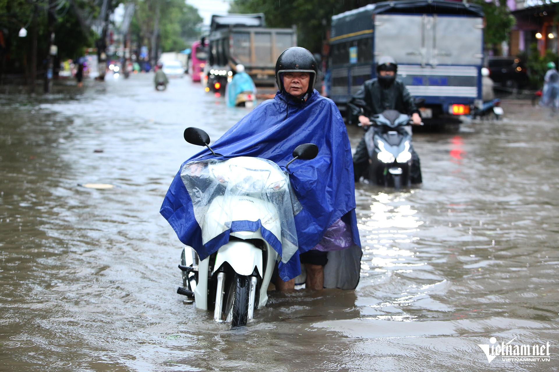
The Northern region has scattered showers and thunderstorms in some places, with heavy rain in some places; the Northwest region has scattered showers and thunderstorms in some places.
The area from Thanh Hoa to Thua Thien Hue has scattered showers and thunderstorms, with some places experiencing heavy rain. From the night of October 20, the area from Southern Nghe An to Thua Thien Hue has moderate rain and scattered thunderstorms, with some places experiencing heavy to very heavy rain.
The area from Da Nang to Binh Thuan has scattered showers and thunderstorms, with some places experiencing heavy rain; the area from Da Nang to Quang Ngai from the night of October 20 has moderate rain and scattered thunderstorms, with some places experiencing heavy to very heavy rain.
In the afternoon and evening, the Central Highlands and the South will have scattered showers and thunderstorms, with some places experiencing heavy rain; in the Central Highlands, there will be scattered showers and thunderstorms, with some places experiencing heavy rain. During thunderstorms, there is a possibility of tornadoes, lightning, and strong gusts of wind.
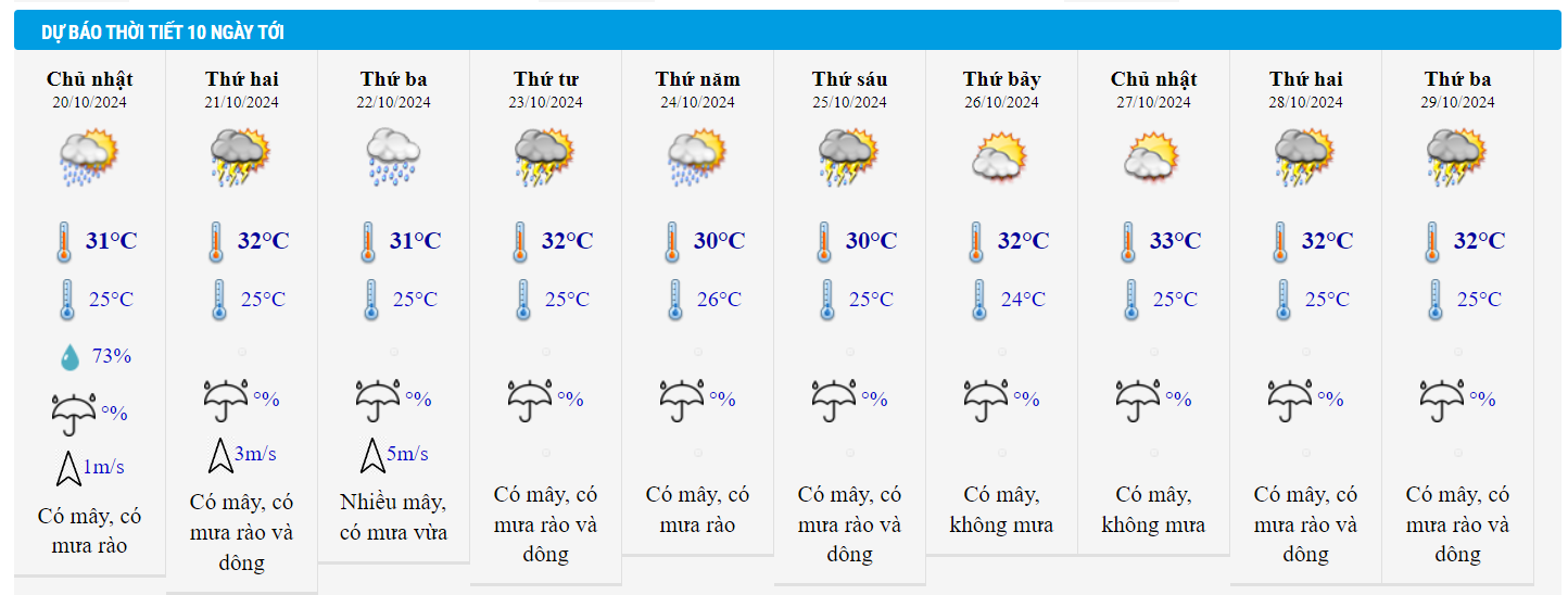
Detailed weather forecast for tonight and October 20, 2024 for regions across the country:
Hanoi
Cloudy with showers and thunderstorms at times. Light winds. Thunderstorms with possibility of tornadoes, lightning and strong gusts of wind.
Lowest temperature: 24-26 degrees.
Highest temperature: 30-32 degrees.
Northwest
Cloudy, scattered showers and thunderstorms, locally heavy rain; in the Northwest region, cloudy, scattered showers and thunderstorms. Light wind. Thunderstorms may cause tornadoes, lightning and strong gusts of wind.
Lowest temperature: 22-25 degrees, some places below 21 degrees.
Highest temperature: 29-32 degrees.
Northeast
Cloudy with scattered showers and thunderstorms, locally heavy rain. Light winds. Thunderstorms with possibility of tornadoes, lightning and strong gusts of wind.
Lowest temperature: 23-26 degrees, mountainous areas below 23 degrees.
Highest temperature: 29-32 degrees.
Thanh Hoa – Thua Thien Hue
Cloudy with scattered showers and thunderstorms, locally heavy rain. Light winds. Thunderstorms with possibility of tornadoes, lightning and strong gusts of wind.
Lowest temperature: 23-26 degrees.
Highest temperature: 29-32 degrees
Da Nang – Binh Thuan
Cloudy with scattered showers and thunderstorms, locally heavy rain. Light winds. Thunderstorms with possibility of tornadoes, lightning and strong gusts of wind.
Lowest temperature: 23-26 degrees.
Highest temperature: 29-32 degrees
Central Highlands
Cloudy, scattered showers and thunderstorms, scattered showers and thunderstorms tonight and tomorrow afternoon, locally heavy rain. Light wind. Thunderstorms may cause tornadoes, lightning and strong gusts of wind.
Lowest temperature: 19-22 degrees.
Highest temperature: 28-31 degrees.
Southern Vietnam
Cloudy, scattered showers and thunderstorms; scattered showers and thunderstorms tonight and tomorrow afternoon, locally heavy rain. Light wind. Thunderstorms may produce tornadoes, lightning and strong gusts of wind.
Lowest temperature: 23-26 degrees.
Highest temperature: 30-33 degrees.
Weather in Ho Chi Minh City in the coming days:
The development of 2 cold air waves, the East Sea is likely to have a tropical depression/storm. The North is starting to have 2 consecutive cold air waves, the temperature is low, the weather is cold in the mountains. From about October 23-25, the East Sea is likely to have tropical depression/storm activity.


![[Photo] Prime Minister Pham Minh Chinh chairs conference on anti-smuggling, trade fraud, and counterfeit goods](https://vphoto.vietnam.vn/thumb/1200x675/vietnam/resource/IMAGE/2025/5/14/6cd67667e99e4248b7d4f587fd21e37c)


Comment (0)