
Mr. Nguyen Van Huong shared about the possibility of storms overlapping storms in the East Sea.
Mr. Nguyen Van Huong - Head of Weather Forecast Department, National Center for Hydro-Meteorological Forecasting said that there are 3 storms active in the Northwest Pacific.
First is Typhoon No. 7 (international name Yinxing). Typhoon No. 7 is active in the East Sea area of Vietnam. Another storm is Typhoon Toraji active in the eastern area of the Philippines and another one is offshore in the Northwest Pacific named Man-yi.
In addition, there is another tropical depression sandwiched between storm Toraji and storm Man-yi.
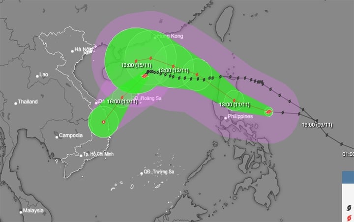
Storm No. 7 continues to weaken, heading towards the mainland of Quang Nam-Binh Dinh, while storm No. Toraji approaches the East Sea. (Source: NCHMF)
According to Mr. Huong, these three storms and tropical depressions are all located on a tropical convergence zone whose axis passes through the North East Sea. And tropical depressions or storms that form on a tropical convergence zone often move in the direction of the tropical convergence zone axis.
"This explains why in the near future, the East Sea will continuously receive tropical cyclones, first storm No. 7, after about 24-48 hours it could be storm No. 8 and it is also possible that storm No. 9 may appear in the near future. With such continuous storms, dangerous weather conditions at sea will continue for a long time," Mr. Huong commented.
According to the meteorological agency's forecast, at 1:00 p.m. on November 10, the center of storm No. 7 (international name Yinxing) was located in the western sea area of the North East Sea, about 240 km northeast of the Hoang Sa archipelago. The strongest wind near the center of the storm was level 12 (118-133 km/h), gusting to level 14, the storm was moving southwest at a speed of about 5 km/h.
In the next 24 hours, the storm in the sea northwest of Hoang Sa archipelago will move southwest at about 10 km per hour and continue to weaken. The strongest wind near the storm center is level 8, gusting to level 10.
At around 1:00 p.m. on November 12, storm No. 7 on the mainland of Quang Nam-Binh Dinh, did not change direction, speed about 15 km/h, weakened into a low pressure area.
In addition, at 1:00 p.m. on November 10, the center of storm Toraji was located in the sea northeast of Luzon Island (Philippines). The strongest wind near the center of the storm was level 11 (103-117 km/h), gusting to level 13. The storm moved west-northwest at a speed of 15-20 km/h.
Typhoon Toraji is likely to move into the East Sea in the evening to the night of November 11, becoming the eighth typhoon in 2024 to operate in this sea area.
According to the National Center for Hydro-Meteorological Forecasting, from early morning on November 12 to November 13, Thua Thien Hue to Binh Dinh is likely to experience moderate to heavy rain, with some areas experiencing very heavy rain with rainfall ranging from 70-150 mm, and over 250 mm in some places. From the night of November 13, heavy rain will gradually decrease in this area.
Heavy rain and localized heavy rain can cause flooding in low-lying areas, flash floods on small rivers and streams, and landslides on steep slopes.
Source: https://vtcnews.vn/du-bao-bien-dong-don-3-con-bao-lien-tiep-mien-trung-hung-mua-lon-ar906601.html
![[Photo] Buddha's Birthday 2025: Honoring the message of love, wisdom, and tolerance](https://vphoto.vietnam.vn/thumb/1200x675/vietnam/resource/IMAGE/2025/5/12/8cd2a70beb264374b41fc5d36add6c3d)
![[Photo] Prime Minister Pham Minh Chinh works with the Standing Committee of Thai Binh Provincial Party Committee](https://vphoto.vietnam.vn/thumb/1200x675/vietnam/resource/IMAGE/2025/5/12/f514ab990c544e05a446f77bba59c7d1)


![[Photo] Prime Minister Pham Minh Chinh starts construction of vital highway through Thai Binh and Nam Dinh](https://vphoto.vietnam.vn/thumb/1200x675/vietnam/resource/IMAGE/2025/5/12/52d98584ccea4c8dbf7c7f7484433af5)


Comment (0)