
Latest storm news: Update on forecast and path of storm number 7
At 7:00 p.m. on November 10, the center of the storm was at about 18.5 degrees North latitude; 112.7 degrees East longitude, in the western sea area of the North East Sea, about 210 km north of the Hoang Sa archipelago. The strongest wind near the center of the storm was level 11 (103-117 km/h), gusting to level 13. Moving southwest at a speed of about 5 km/h.
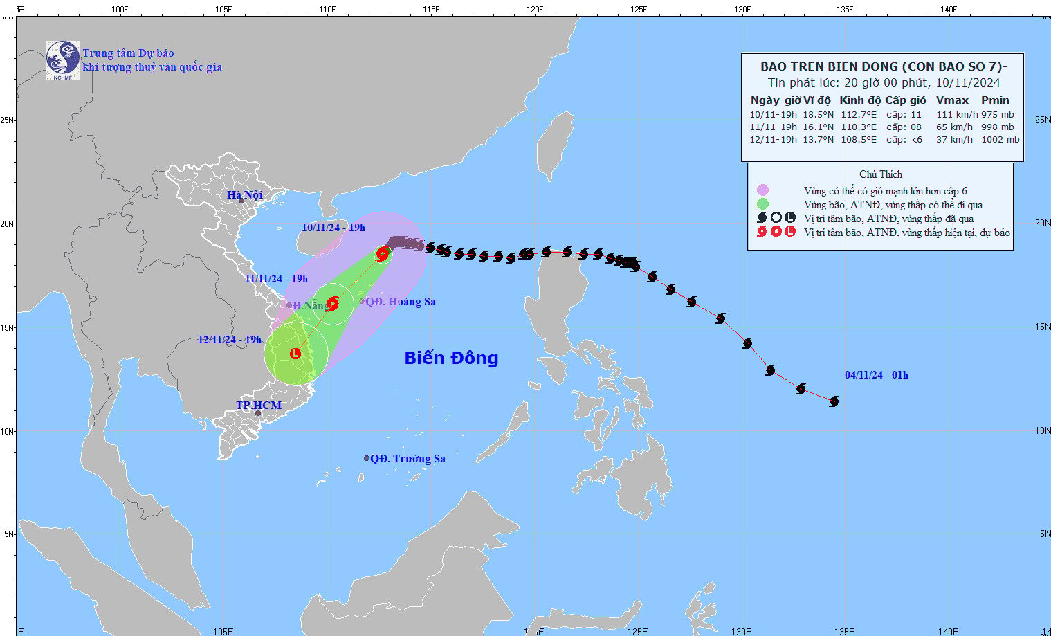
Latest storm news: Developments in the location and intensity of two storms in the East Sea. Photo: NCHMF
Forecast of storm No. 7 in the next 24 to 48 hours:
Forecast time | Direction, speed | Location | Intensity | Danger zone | Disaster Risk Level (Affected Area) |
19:00/11/11 | Southwest, about 15km/h, continuing to weaken | 16.1N-110.3E; in the sea west of Hoang Sa archipelago | Level 8, level 10 | Latitude 15.0N-20.0N; longitude 109.0E-114.5E | Level 3: Western sea area of the North East Sea (including the sea area of Hoang Sa archipelago) |
19:00/12/11 | Southwest, about 15km/h, weakening into a low pressure area | 13.7N-108.5E; in the Gia Lai - Binh Dinh area | Latitude 14.0N-18.0N; West of longitude 112.0E | Level 3: sea area west of Hoang Sa archipelago, offshore sea area from Thua Thien Hue to Binh Dinh |
At sea: The western sea area of the North East Sea (including the sea area of Hoang Sa archipelago) has strong winds of level 7-8, near the storm's eye level 9-11, gusting to level 13, waves 3.0-5.0m high, near the eye 5.0-7.0m; rough seas.
From the morning of November 11, the sea off the coast of Thua Thien Hue to Binh Dinh will have winds gradually increasing to level 6-7, gusting to level 9, waves 2.0-4.0m high; rough seas.
Vessels operating in the above mentioned dangerous areas are susceptible to the impact of storms, whirlwinds, strong winds and large waves.
Storm No. 8 is likely to follow Storm No. 7 into the East Sea.
The National Center for Hydro-Meteorological Forecasting said that at 7 p.m. on November 10, the center of storm Toraji was at about 15.4 degrees North latitude; 124.3 degrees East longitude, in the sea northeast of Luzon Island (Philippines). The strongest wind near the center of the storm was level 11 (103-117 km/h), gusting to level 13. Moving in the West Northwest direction, speed about 20 km/h.
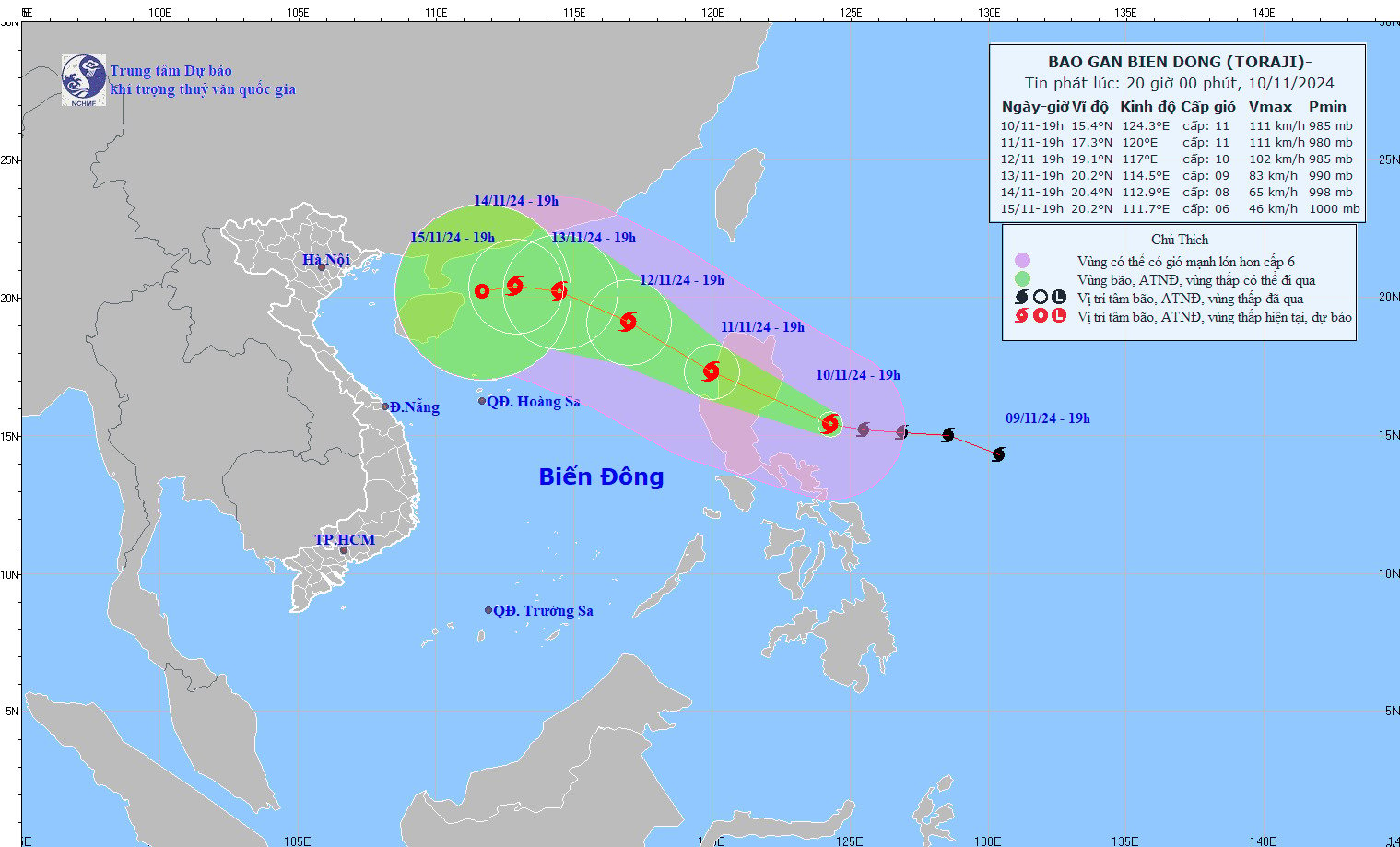
Updated location and path of typhoon Toraji. Photo: NCHMF
Forecast of storm Toraji's development in the next 24 to 72 hours:
By 7:00 p.m. on November 11: The storm is moving in the West-Northwest direction at a speed of about 20 km/h, located at 17.3 degrees North latitude - 120.0 degrees East longitude, in the sea area east of the North East Sea. The intensity reaches level 11, gusts level 13. The dangerous area is between latitude 14.0 degrees North - 19.5 degrees North and east of longitude 118.0 degrees East. Disaster risk level: level 3 in the east of the North East Sea.
By 7:00 p.m. on November 12: The storm moves northwest at a speed of about 15 km/h, into the East Sea. Location is at 19.1 degrees North latitude - 117.0 degrees East longitude, in the sea area east of the North East Sea. Intensity decreases to level 10, gusts to level 12. Dangerous area from latitude 15.5 degrees North - 21.0 degrees North and east of longitude 115.0 degrees East. Disaster risk level: level 3 in the east of the North East Sea area.
By 7:00 p.m. on November 13: The storm is moving in the West-Northwest direction at a speed of about 10 km/h, located at 20.2 degrees North latitude - 114.5 degrees East longitude, in the North of the North East Sea. The intensity has decreased to level 9, gusting to level 11. The dangerous area is between latitude 17.5 degrees North - 22.0 degrees North and longitude 112.5 degrees East - 119.0 degrees East. Disaster risk level: level 3 in the North of the North East Sea.
Storm development warning (from next 72 to 120 hours): In the next 72 to 120 hours, the storm tends to move in the West Northwest direction, then is likely to change direction to West Southwest, moving at a speed of 5-10 km/h and continue to weaken further.
From the next 72 to 120 hours, storm Toraji will move in the West Northwest direction, then likely change to the West Southwest direction, moving 5-10km per hour, and its intensity will continue to weaken.
From November 11, the eastern sea area of the North East Sea will have strong winds of level 6-7, then increasing to level 8-9, near the storm center will have winds of level 10-11, gusting to level 13, waves 3.0-5.0m high, near the center 5.0-7.0m; rough seas.
Vessels operating in the above mentioned dangerous areas are susceptible to the impact of storms, whirlwinds, strong winds and large waves.
With this development, the meteorological agency recommends that people in the central coastal areas, especially from Quang Tri to Quang Ngai, need to closely monitor the storm situation and prepare response plans to minimize risks.
![[Photo] Prime Minister Pham Minh Chinh chairs conference on breakthrough solutions for social housing development](https://vphoto.vietnam.vn/thumb/1200x675/vietnam/resource/IMAGE/2025/10/24/1761294193033_dsc-0146-7834-jpg.webp)
![[Photo] President Luong Cuong chaired the welcoming ceremony and held talks with United Nations Secretary-General Antonio Guterres](https://vphoto.vietnam.vn/thumb/1200x675/vietnam/resource/IMAGE/2025/10/24/1761304699186_ndo_br_1-jpg.webp)
![[Photo] Prime Minister Pham Minh Chinh and South African President Matamela Cyril Ramaphosa attend the business forum](https://vphoto.vietnam.vn/thumb/1200x675/vietnam/resource/IMAGE/2025/10/24/1761302295638_dsc-0409-jpg.webp)
![[Photo] Solemn funeral of former Vice Chairman of the Council of Ministers Tran Phuong](https://vphoto.vietnam.vn/thumb/1200x675/vietnam/resource/IMAGE/2025/10/24/1761295093441_tang-le-tran-phuong-1998-4576-jpg.webp)


Comment (0)