
Latest storm news update: Location and path of storm number 7
According to the latest news from the National Center for Hydro-Meteorological Forecasting a few minutes ago, at 13:00 (November 10), the center of the storm was located at about 18.8 degrees North latitude; 113.0 degrees East longitude, in the western sea area of the North East Sea, about 240km northeast of the Hoang Sa archipelago. The strongest wind near the center of the storm is level 12 (118-13km/h), gusting to level 14. Moving in a southwest direction, at a speed of about 5km/h.

Latest storm news: Meteorological experts warn of double storms appearing in the East Sea, localities develop response plans
Forecast of storm No. 7 Yinxing in the next 24 to 48 hours
Regarding the impact of storm No. 7: The western sea area of the North East Sea (including the sea area of Hoang Sa archipelago) has strong winds of level 7-9, the area near the storm's center has winds of level 10-12, gusts of level 14, waves 4.0-6.0m high, the area near the center is 6.0-8.0m; the sea is very rough.
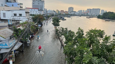
From early morning on November 11, the sea off the coast of Quang Tri to Quang Ngai has gradually increased winds to level 6-7, gusting to level 9, waves 2.0-4.0m high; rough seas.
Vessels operating in the above mentioned dangerous areas are susceptible to the impact of storms, whirlwinds, strong winds and large waves.
This storm has not passed, another storm is coming in the East Sea
On the morning of November 10, sharing with PV Dan Viet, Mr. Nguyen Van Huong, Head of Weather Forecast Department, National Center for Hydro-Meteorological Forecasting, has just shared an update on the natural disaster developments in the East Sea in the coming days. On the morning of November 4, a tropical depression in the eastern region of the Philippines strengthened into a storm with the international name YINXING. This is the 22nd storm in the Northwest Pacific .

Mr. Nguyen Van Huong, Head of Weather Forecast Department, National Center for Hydro-Meteorological Forecasting, has just shared an update on natural disasters in the East Sea in the coming days.
On the afternoon of November 7, storm YINXING made landfall in the eastern part of the Philippines; by the early morning of November 8, storm YINXING moved into the East Sea and became storm No. 7; by the afternoon of November 9, storm No. 7 had its strongest intensity at level 14-15; after reaching its strongest intensity yesterday afternoon, from the night of November 9, storm No. 7 stabilized and by early this morning (November 10), it changed direction and moved south, its intensity rapidly decreasing.
Environmental conditions affect the movement and intensity of storm No. 7. Since last night, storm No. 7 has moved into an area with unfavorable environmental conditions for storm development; first, the current sea surface temperature in the western area of the Paracel Islands is below optimal, below 26 degrees, reducing the energy supply to the storm, contributing to its gradual weakening.
Second, the cold and dry air mass still prevails, so the relative humidity in the atmosphere from the ground to an altitude of 1500m is very low, limiting the development of storm clouds; in addition, there is currently a new storm in the eastern part of the Philippines, internationally named TORAJI, which is active tomorrow morning when it moves into the eastern part of Luzon Island (Philippines), the distance between storm No. 7 (YINXING) and storm TORAJI is about 1200-1400km, which is the distance where double storm interaction occurs, storm TORAJI will cause storm No. 7 (YINXING) to deviate more to the south.
“The current forecast at 11am on November 10 is that in the next 24-48 hours, the storm is expected to continue moving southwest and its intensity will rapidly decrease to below level 10 due to unfavorable conditions of temperature and humidity,” said Mr. Nguyen Van Huong.
For storm No. 7, the most dangerous impact is the strong wind at sea, with the western sea area of the North East Sea having strong winds of level 7-9, near the eye of the storm level 10-13, gusts of level 16, waves 4.0-6.0m high, near the eye of the storm 6.0-8.0m; rough seas. From early morning on November 11, the sea area from Quang Tri to Quang Ngai has strong winds of level 6-7, near the eye of the storm level 8, gusts of level 10, waves 2.0-4.0m high, near the eye of the storm 3.0-5.0m; rough seas. Vessels operating in the above dangerous areas are likely to be affected by storms, whirlwinds, strong winds, and big waves.
The East Sea may welcome storm No. 8 right after storm No. 7, heavy rain in the provinces
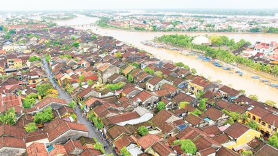
Mr. Nguyen Van Huong said that due to the influence of storm No. 7 from tomorrow evening and night until the end of November 12, there will be rain in the Central and South Central regions, but there is very little possibility of extreme rain causing floods on rivers in the Central region.
These are impact warnings based on current data. People in coastal areas of the Central region, especially from Quang Tri to Quang Ngai, need to closely monitor the storm situation and prepare response plans to minimize risks.

The movement of the two storms (Photo: NCHMF).
Regarding the weather developments in the East Sea next week, Mr. Nguyen Van Huong said that currently in the eastern part of the Philippines there are 2 storms and 1 tropical depression active, storm TORAJI is likely to move into the East Sea in the evening to the night of November 11, so after storm No. 7, storm No. 8 will appear; under the impact of storm No. 7 and then storm No. 8, the northern and central areas of the East Sea in the coming days will continuously have bad weather, with strong winds, high waves and rough seas.
Responding to weather developments at sea, the Minister of Agriculture and Rural Development has just sent a telegram to the People's Committees of coastal provinces and cities from Quang Ninh to Binh Thuan to proactively respond to storm developments.
Localities closely monitor the storm's developments; manage vessels at sea; organize ship and boat counting; notify owners of vessels and captains of vessels operating at sea of the location, direction of movement and developments of the storm to proactively avoid, escape or not move into dangerous areas. Dangerous areas in the next 24 hours: From latitude 16.5-21.0 degrees North, east of longitude 119.0 degrees East; in the next 48 hours: From latitude 15.0-21.0 degrees North, east of longitude 117.5 degrees East (dangerous areas are adjusted according to forecasts). Be ready with forces and means for rescue when requested.
Vietnam Television, Voice of Vietnam, Vietnam News Agency, coastal information stations and mass media agencies from central to local levels have increased measures to inform about the storm's developments to authorities at all levels and people so that they can proactively prevent and respond promptly and effectively. Ministries and branches, according to their functions, state management tasks and assigned tasks, proactively direct and coordinate with localities to respond to the storm's developments.
![[Photo] Close-up of Ba Ha River Hydropower Plant operating to regulate water to downstream](/_next/image?url=https%3A%2F%2Fvphoto.vietnam.vn%2Fthumb%2F1200x675%2Fvietnam%2Fresource%2FIMAGE%2F2025%2F11%2F25%2F1764059721084_image-6486-jpg.webp&w=3840&q=75)


![[Photo] Prime Minister Pham Minh Chinh receives Governor of Gunma Prefecture (Japan) and Special Advisor to the Japan-Vietnam Friendship Parliamentary Alliance](/_next/image?url=https%3A%2F%2Fvphoto.vietnam.vn%2Fthumb%2F1200x675%2Fvietnam%2Fresource%2FIMAGE%2F2025%2F11%2F25%2F1764066321008_dsc-1312-jpg.webp&w=3840&q=75)


![[Answer] Should I install an elevator for an old renovated house?](https://vphoto.vietnam.vn/thumb/402x226/vietnam/resource/IMAGE/2025/11/25/1764039191595_co-nen-lap-thang-may-cho-nha-cai-tao-cu-khong-04.jpeg)


Comment (0)