
On the afternoon of June 19, the National Center for Hydro-Meteorological Forecasting sent a document to the Standing Office of the National Steering Committee for Natural Disaster Prevention and Control, assessing the possibility of a tropical cyclone appearing in the East Sea.
Through monitoring and analyzing the current state of the weather system and forecast products, the meteorological agency determined that around June 22-23, a low pressure area is likely to form in the northern and central East Sea.
This low pressure area can then strengthen into a tropical depression with a probability of 65-75%, the storm formation scenario is about 20-30%.
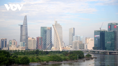
If the above scenario occurs, this will be the second tropical cyclone to form in the East Sea this year. Previously, the area welcomed storm No. 1 in late May but it did not affect the weather on land.
The meteorological agency warned that on June 23-25, a tropical depression or storm will directly affect the northern and central areas of the East Sea (including the waters of the Hoang Sa archipelago) and the Gulf of Tonkin.

Storm No. 1 forming in the East Sea has no impact on the weather in our country's mainland (Photo: VNDMS).
Under the influence of the above morphology, the northern and central areas of the East Sea (including the waters of the Hoang Sa archipelago) will have bad weather on June 23-25.
In addition, the southwest monsoon is tending to be strong, the central and southern East Sea (including the waters of Truong Sa archipelago), the waters from Binh Dinh to Ca Mau, Ca Mau to Kien Giang and the Gulf of Thailand will have heavy showers and thunderstorms.
Thunderstorms may be accompanied by tornadoes and strong winds of level 6-7, wave heights sometimes increasing to over 2m.
The sea area from Binh Thuan to Ca Mau and the sea area west of the southern East Sea (including the sea area west of Truong Sa archipelago) has strong southwest winds of level 5-6, gusting to level 7-8. Waves are 1.5-2.5m high, rough seas.
In its long-term forecast, the National Center for Hydro-Meteorological Forecasting said that from now until September, the East Sea is likely to see 5-7 storms or tropical depressions, of which 2-3 will make landfall. This number is equivalent to the average of many years.
Source: https://dantri.com.vn/xa-hoi/bien-dong-co-the-don-bao-tuan-toi-20240619172743728.htm
![[Photo] Vietnam and Sri Lanka sign cooperation agreements in many important fields](https://vphoto.vietnam.vn/thumb/1200x675/vietnam/resource/IMAGE/2025/5/5/9d5c9d2cb45e413c91a4b4067947b8c8)


![[Photo] President Luong Cuong and Sri Lankan President Anura Kumara Dissanayaka visit President Ho Chi Minh relic site](https://vphoto.vietnam.vn/thumb/1200x675/vietnam/resource/IMAGE/2025/5/5/0ff75a6ffec545cf8f9538e2c1f7f87a)


![[Photo] President Luong Cuong presided over the welcoming ceremony and held talks with Sri Lankan President Anura Kumara Dissanayaka](https://vphoto.vietnam.vn/thumb/402x226/vietnam/resource/IMAGE/2025/5/5/351b51d72a67458dbd73485caefb7dfb)


Comment (0)