
According to the National Center for Meteorological and Hydrological Forecasting, this morning (September 3rd), Typhoon YAGI entered the northeastern sea area of the North East Sea, becoming the third typhoon of 2024.
At 7:00 AM, the typhoon's center was located at approximately 18.4 degrees North latitude and 119.8 degrees East longitude, in the northeastern part of the South China Sea. The strongest winds near the center of the typhoon were at level 8 (62-74 km/h), with gusts up to level 11, moving in a west-northwest direction at about 20-25 km/h.
The National Center for Hydro-Meteorological Forecasting predicts that over the next two days, Typhoon No. 3 will continuously intensify, potentially reaching level 13 with gusts up to level 16 when it enters the waters east of Hainan Island (China). According to current forecasts, there is a high probability that the typhoon will enter the Gulf of Tonkin around Friday afternoon or evening (September 6th), and is then expected to approach the coastal provinces of Northern and North Central Vietnam from Saturday (September 7th).
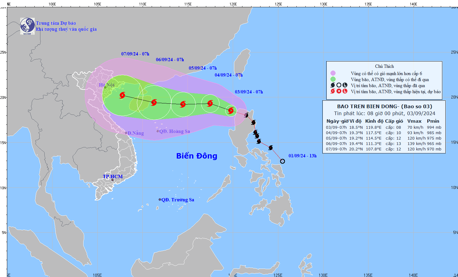
The path of Typhoon Yagi - Typhoon No. 3. Photo: nchmf
Typhoon Yagi - what is the strength level of typhoon number 3?
Currently, all weather forecasts for Typhoon Yagi (Typhoon No. 3) share the same assessment: this could be a strong typhoon. Specifically, according to the National Center for Meteorological and Hydrological Forecasting, as of 7:00 AM on September 4th, Typhoon No. 3 was moving in a west-northwest direction at a speed of approximately 10 km/h, with a typhoon intensity of level 9-10, gusting to level 12.
As of 7:00 AM on September 5th, Typhoon No. 3 was moving westward at a speed of approximately 10 km/h, with an intensity of level 11-12 and gusts up to level 14.
As of 7:00 AM on September 6th, Typhoon No. 3 was moving westward at a speed of approximately 10 km/h, with a storm intensity of level 13 and gusts of level 16.
Forecast of the impact of Typhoon Yagi - Typhoon No. 3
From September 3rd, the northeastern part of the South China Sea will experience increasingly strong winds, reaching level 6, with winds near the storm's center reaching levels 8-9, gusting above levels 11-12; the sea will be rough. Forecasts indicate that between September 4th and 6th, Typhoon Yagi may reach very strong typhoon status in the northeastern South China Sea, with maximum wind speeds potentially reaching levels 12-13, gusting to level 16 near the storm's center.
Over the next 24 hours, in the eastern part of the North East Sea, sea waves will be 2.0-4.0m high, and 3.0-5.0m near the storm's center. After that (September 4-6), they may increase to 5-7m. The sea will be extremely rough and very dangerous for ships.
Source: https://danviet.vn/nong-bao-yagi-da-vao-bien-dong-tro-thanh-con-bao-so-3-cuong-do-con-tang-nguy-co-giat-cap-16-20240903075537352.htm


![[Photo] Prime Minister Pham Minh Chinh holds a phone call with the CEO of Russia's Rosatom Corporation.](/_next/image?url=https%3A%2F%2Fvphoto.vietnam.vn%2Fthumb%2F1200x675%2Fvietnam%2Fresource%2FIMAGE%2F2025%2F12%2F11%2F1765464552365_dsc-5295-jpg.webp&w=3840&q=75)

![[Photo] Closing Ceremony of the 10th Session of the 15th National Assembly](/_next/image?url=https%3A%2F%2Fvphoto.vietnam.vn%2Fthumb%2F1200x675%2Fvietnam%2Fresource%2FIMAGE%2F2025%2F12%2F11%2F1765448959967_image-1437-jpg.webp&w=3840&q=75)


![[OFFICIAL] MISA GROUP ANNOUNCES ITS PIONEERING BRAND POSITIONING IN BUILDING AGENTIC AI FOR BUSINESSES, HOUSEHOLDS, AND THE GOVERNMENT](https://vphoto.vietnam.vn/thumb/402x226/vietnam/resource/IMAGE/2025/12/11/1765444754256_agentic-ai_postfb-scaled.png)


![[Infographic] Preventing students from making their own firecrackers: 7 things parents need to know](https://vphoto.vietnam.vn/thumb/402x226/vietnam/resource/IMAGE/2025/12/11/1765466656703_img_0320_20251211183542.jpeg)


Comment (0)