Meteorological experts warn that storm number 3 (Yagi) is very strong, with peak winds reaching level 14 and gusts of level 17, with waves 7-9m high, sinking even large ships.
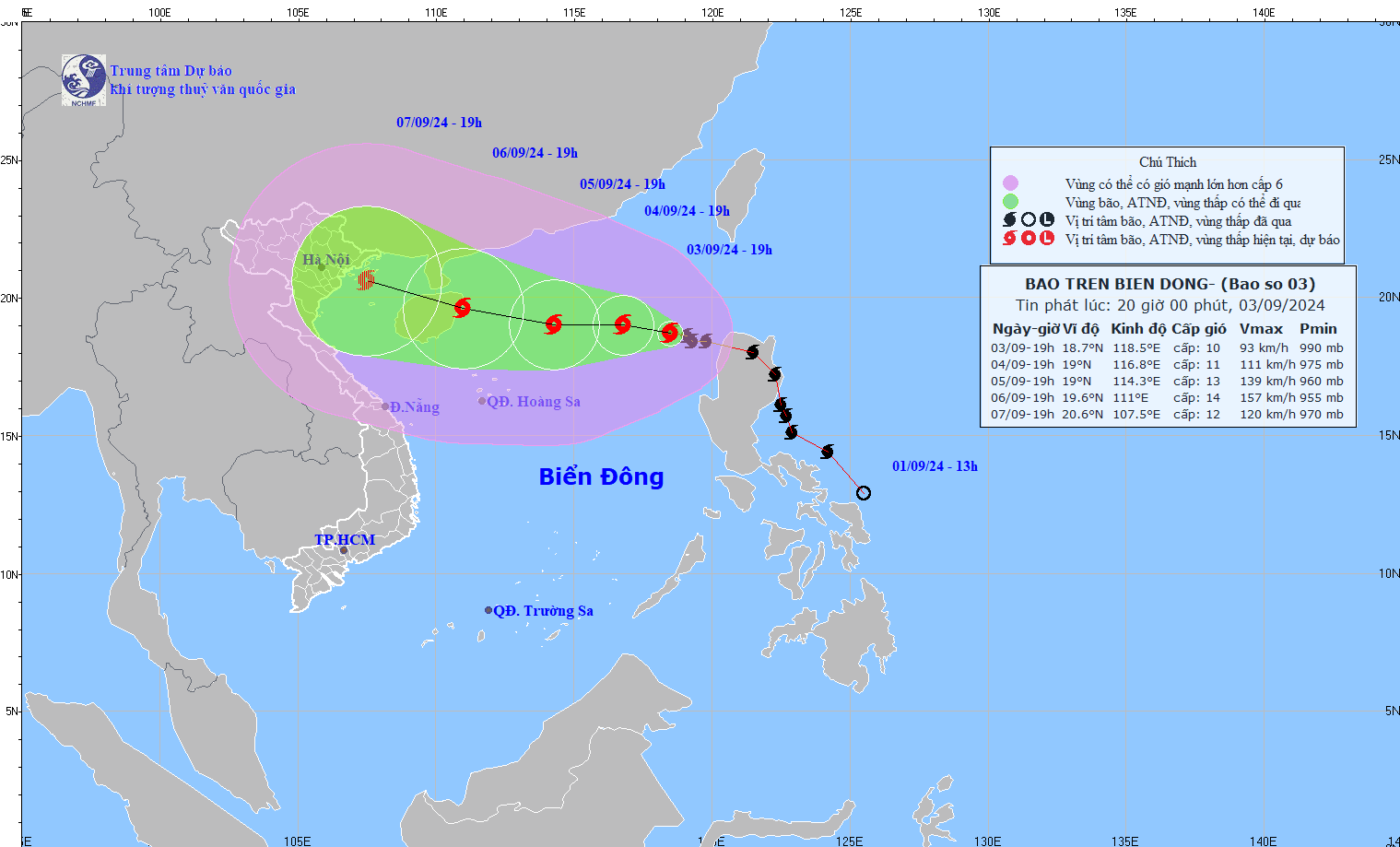
On the evening of September 3, Mr. Vu Anh Tuan, Deputy Head of the Weather Forecast Department of the National Center for Hydro-Meteorological Forecasting, shared details about the forecast and risks of storm No. 3 (Yagi).
Mr. Tuan said: "After entering the East Sea, storm No. 3 tends to move west at a slower speed but shows signs of gradually intensifying."
According to the latest information from Mr. Tuan, as of 5:00 p.m. on September 3, Typhoon Yagi had reached level 10, an increase of 2 levels compared to the morning of the same day. Mr. Tuan warned: "It is forecasted that when moving deep into the East Sea, the storm will continue to increase in strength, possibly reaching a maximum of level 14, gusting to level 17."
[embed]https://www.youtube.com/watch?v=2ryUez8MMmw[/embed]Thus, from the time it entered the East Sea until it reached its peak, the storm increased by 6 levels.
The expert also emphasized the dangerous characteristics of the storm: “The storm’s wind range is very wide. Strong thunderstorms can appear before the storm’s eye.”
From now until the morning of September 6, the storm will move steadily westward at an average speed of about 10-15km/hour. However, after this point, Mr. Tuan said, there are two possible scenarios.
In the first scenario, the storm will move north into the Gulf of Tonkin around the night of September 6 to 7. In the second scenario, the storm will change direction to the southwest, circle south of Hainan Island (China) and down to the south of the Gulf of Tonkin.
Mr. Tuan affirmed that both scenarios would affect the Vietnamese mainland. At the same time, he warned about the strength of the storm: This is a very strong storm, with waves from 7 to 9 meters high, which can sink even large ships.
Updated at 8:00 p.m. from the National Center for Hydro-Meteorological Forecasting, the center of storm No. 3 is located at approximately 18.7 degrees North latitude - 118.5 degrees East longitude, in the eastern sea area of the North East Sea. The strongest wind near the center of the storm is level 10 (from 89 to 102 km/h), gusting to level 12, moving in the West Northwest direction, at approximately 10 km/h.
VAN PHUC
Source: https://www.sggp.org.vn/bao-yagi-co-the-dat-cap-14-giat-cap-17-kha-nang-danh-chim-tau-lon-post757017.html


![[Photo] President Luong Cuong presents the decision to appoint Deputy Head of the Office of the President](https://vphoto.vietnam.vn/thumb/1200x675/vietnam/resource/IMAGE/2025/5/8/501f8ee192f3476ab9f7579c57b423ad)

![[Photo] National Assembly Chairman Tran Thanh Man chairs the meeting of the Subcommittee on Documents of the First National Assembly Party Congress](https://vphoto.vietnam.vn/thumb/1200x675/vietnam/resource/IMAGE/2025/5/8/72b19a73d94a4affab411fd8c87f4f8d)
![[Photo] General Secretary To Lam begins official visit to Russia and attends the 80th Anniversary of Victory over Fascism](https://vphoto.vietnam.vn/thumb/1200x675/vietnam/resource/IMAGE/2025/5/8/5d2566d7f67d4a1e9b88bc677831ec9d)

![[Photo] Prime Minister Pham Minh Chinh meets with the Policy Advisory Council on Private Economic Development](https://vphoto.vietnam.vn/thumb/1200x675/vietnam/resource/IMAGE/2025/5/8/387da60b85cc489ab2aed8442fc3b14a)

















Comment (0)