
Typhoon Toraji has entered the eastern sea of the North East Sea, becoming the 8th typhoon of 2024. It is forecasted that in the next 2-3 days, the storm will weaken rapidly and dissipate at sea.
According to the National Center for Hydro-Meteorological Forecasting, at 10:00 p.m. on November 11, the center of storm No. 8 (Toraji) was located in the eastern sea of the North East Sea. The strongest wind near the center of the storm was level 11 (103-117 km/h), gusting to level 13. Moving northwest at a speed of about 20 km/h.
In the next 24 hours, storm No. 8 will maintain its direction of movement, at a speed of 15-20km/h. By 10pm tomorrow night (November 12), the storm's center will be located in the eastern sea area of the North East Sea, with its intensity decreasing to level 9-10, gusting to level 12.
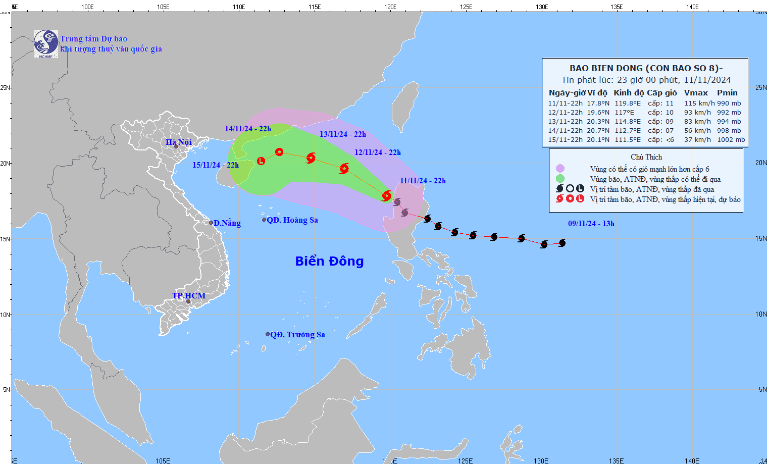
The storm then changed direction to move West Northwest at a speed of 10-15km/h, gradually weakening in intensity. At 10pm on November 13, the storm's center was located in the northern sea area of the North East Sea and its intensity decreased to level 8-9, gusting to level 11.
In the following hours, the storm moved northward into the North East Sea at a speed of about 10km/h and gradually weakened into a tropical depression.
From the next 72 to 96 hours, the tropical depression will move in the West Southwest direction, about 5km per hour, and its intensity will continue to weaken.
Thus, storm number 8 after entering the East Sea tends to weaken quickly and dissipate at sea.
However, due to the influence of storm No. 8, the eastern sea area of the North East Sea has strong winds of level 6-7, then increasing to level 8, the area near the storm's eye has levels 9-11, gusts of level 12, waves 3-5m high, the area near the storm's eye has 5-7m; the sea is very rough.
Ships operating in the above mentioned dangerous areas are likely to be affected by storms, whirlwinds, strong winds and large waves.
In addition, meteorological experts say the East Sea may welcome storm No. 9 in the near future, as off the coast of the Philippines there is a tropical depression and a distant storm active.
Series of 3 storms and tropical depressions, possibility of storm number 9

Cold air changes are unexpected from now until December
Source: https://vietnamnet.vn/bao-toraji-tro-thanh-bao-so-8-kha-nang-tan-ngay-tren-bien-dong-2341060.html


![[Photo] Prime Minister Pham Minh Chinh chairs conference on anti-smuggling, trade fraud, and counterfeit goods](https://vphoto.vietnam.vn/thumb/1200x675/vietnam/resource/IMAGE/2025/5/14/6cd67667e99e4248b7d4f587fd21e37c)


Comment (0)