
Video : Weather forecast for October 27
Storm Trami (storm number 6) has an unusual and unpredictable trajectory this storm season due to the influence of many weather patterns. It is expected to have the strongest impact from noon to this afternoon.
The National Center for Hydro-Meteorological Forecasting said that the development of storm No. 6 is still very complicated and may change.
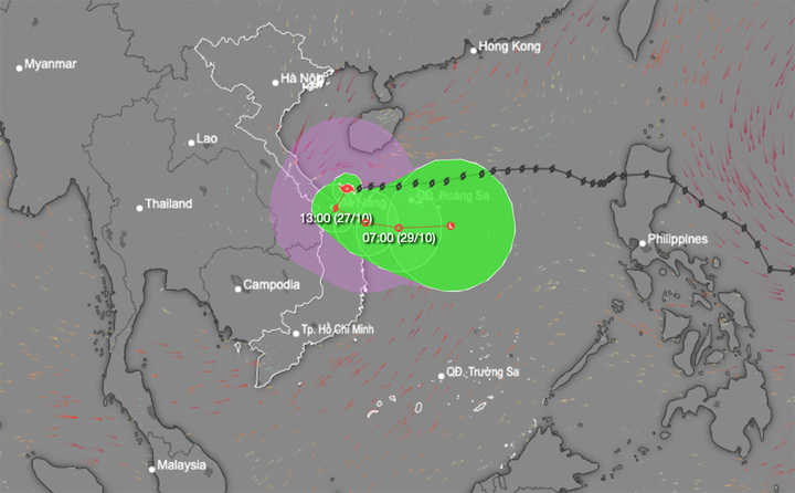
At 7:00 a.m. on October 27, the center of storm No. 6 was located on the sea from Quang Tri to Quang Nam . The strongest wind near the center of the storm was level 9-10 (75-102 km/h), gusting to level 12, the storm moved west at a speed of 15-20 km/h.
According to the meteorological agency, the development of storm No. 6 is still very complicated. (Source: NCHMF)
Forecast in the next 24 hours, the storm in the coastal waters of Central Central Vietnam, change direction Southwest then turn East Southeast and move slowly, traveling 5-10km per hour, weakening into a tropical depression. The strongest wind near the storm center is level 6-7, gusting to level 9.
At around 7am on October 29, a tropical depression in the sea off the Central Central Coast moved east at a speed of 5-10km/h. The strongest wind near the center of the depression was at level 6, gusting to level 8.
At 7:00 a.m. on October 30, the tropical depression in the sea southeast of Hoang Sa archipelago, moving east at a speed of about 10 km/h, weakened into a low pressure area.
Affected by the circulation of storm No. 6, at Con Co Island (Quang Tri), strong winds of level 8, gusts of level 9; Cu Lao Cham Island (Quang Nam) strong winds of level 8, gusts of level 10; Ly Son Island (Quang Ngai) level 6, gusts of level 7; Nam Dong (Thua Thien Hue) strong winds of level 7; Thua Thien Hue strong winds of level 6, gusts of level 8; Ba Na ( Da Nang ) strong winds of level 6, gusts of level 13.
Quang Binh - Da Nang had heavy rain, common rainfall 50-150mm, locally heavy rain over 250mm.
From today, October 27 to the night of October 28, Quang Binh to Quang Nam will continue to experience heavy to very heavy rain, with total rainfall ranging from 200-400mm, with some places over 600mm. There is a risk of localized heavy rain (over 100mm/3 hours).
Ha Tinh, Quang Ngai, Binh Dinh and the Northern Central Highlands have heavy rain, some places have very heavy rain, total rainfall is commonly 100-180mm, some places over 250mm.
In the coming hours, there is a risk of flash floods on small rivers and streams, and landslides on steep slopes in many districts. Specifically:
| Province/City | District |
| Ha Tinh | Ky Anh, Ky Anh town |
| Quang Binh | Bo Trach, Le Thuy, Quang Ninh, Quang Trach, Tuyen Hoa |
| Quang Tri | Cam Lo, Dakrong, Gio Linh, Hai Lang, Huong Hoa, Trieu Phong, Vinh Linh |
| Thua Thien Hue | A Luoi, Nam Dong, Phong Dien, Phu Loc, Huong Thuy town, Huong Tra town |
| Danang | Hoa Vang, Lien Chieu district, Ngu Hanh Son district, Son Tra district |
| Quang Nam | Dai Loc, Dong Giang, Hiep Duc, Nam Giang, Nam Tra My, Nong Son, Nui Thanh, Phu Ninh, Phuoc Son, Que Son, Tay Giang, Tien Phuoc |
| Kon Tum | Dak Glei, Dak Ha, Ia H' Drai, Kon Plong, Kon Ray, Tu Mo Rong |
Source: https://vtcnews.vn/bao-so-6-tren-vung-bien-quang-tri-den-quang-nam-dien-bien-rat-phuc-tap-ar904106.html
![[Photo] Party and State leaders attend the special art program "You are Ho Chi Minh"](https://vphoto.vietnam.vn/thumb/1200x675/vietnam/resource/IMAGE/2025/5/18/6895913f94fd4c51aa4564ab14c3f250)


![[Photo] Ready for the top competitions of Vietnamese table tennis](https://vphoto.vietnam.vn/thumb/1200x675/vietnam/resource/IMAGE/2025/5/18/9c547c497c5a4ade8f98c8e7d44f5a41)
![[Photo] Many young people patiently lined up under the hot sun to receive a special supplement from Nhan Dan Newspaper.](https://vphoto.vietnam.vn/thumb/1200x675/vietnam/resource/IMAGE/2025/5/18/6f19d322f9364f0ebb6fbfe9377842d3)


Comment (0)