
Storm No. 6 mainly directly impacted the central coastal region, causing heavy rain in many provinces and cities from around the evening of October 26. The focus of heavy rain fell on 5 provinces from Quang Binh to Quang Nam, with the risk of flooding and landslides.
This afternoon (October 25), Mr. Hoang Phuc Lam, Deputy Director of the National Center for Hydro-Meteorological Forecasting, said that storm Tra Mi has become the 6th storm in 2024. From yesterday afternoon to today, the storm has been moving relatively steadily and quite quickly at a speed of 15-20km/h, heading towards the Hoang Sa archipelago.
In the next 24 to 48 hours, the storm will continue to move steadily and become stronger.
"The maximum intensity we forecast when the storm is in the East of Hoang Sa archipelago, can reach level 11-12, gusting to level 15," said Mr. Lam.
Regarding the possibility of interaction with cold air, Mr. Lam said that when the storm enters the Hoang Sa archipelago, it tends to move slowly and weaken due to the cold air moving from the North to the South. This impact causes the storm to weaken and be pushed to the South. After that, the storm is likely to weaken to level 7-8 and tend to move outward.

According to Mr. Lam, at this time, the storm has lasted for a relatively long time, leading to the formation of a tropical convergence zone in the Central and Southern East Sea, causing prolonged rain in the Central region.
Mr. Lam also informed that another less likely scenario is when the storm enters the Hoang Sa area and interacts with cold air, it weakens, but still moves ashore and weakens over the mainland of our country. This scenario is less likely to happen than the possibility of the storm drifting to the South and moving out.
The latter scenario is estimated at about 60%, the inland scenario at about 30%.
However, Mr. Lam noted: “In both scenarios, we still emphasize the issue of heavy rain in the Central Central region. This is the area most clearly affected by storm No. 6.
From the evening and night of October 26, the provinces from Ha Tinh to Quang Ngai will experience moderate to heavy rain. The rain will mainly fall in the provinces of Quang Binh, Quang Tri, Thua Thien Hue, Da Nang to Quang Nam.
Specifically, from the evening and night of October 26 to 28, in the area from Quang Tri to Quang Ngai, there will be heavy to very heavy rain with total rainfall from 300-500mm, locally over 700mm. Warning of the risk of local heavy rain (>100mm/3 hours). The areas of Ha Tinh - Quang Binh, Binh Dinh and the Northern Central Highlands will have heavy rain, locally very heavy rain with total rainfall from 100-200mm, some places over 300mm".
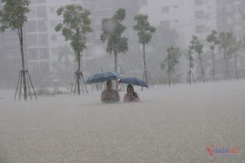
At the same time, Mr. Lam warned that it is necessary to pay attention to heavy rain concentrated in a short period of time, when the storm approaches the coast of Vietnam, there is a possibility of flash floods and landslides. In addition, in Da Nang, urban flooding has occurred when the rainfall reached 400-500mm within 1 day, so this time there may also be a risk. Third, on rivers and reservoirs, heavy rainfall causes water levels to rise.
Storm No. 6 will mainly directly impact the central coastal area from Ha Tinh to Binh Dinh, causing strong winds of level 6-8, level 9-10 near the storm center, waves 4-6m high, very rough seas, and heavy rain and thunderstorms.
Mr. Lam emphasized that the highest risk in the next 1-2 days, while the storm is still at sea, is for boats and fishing activities at sea; then for coastal areas related to cages, aquaculture areas, boat moorings, etc.
According to meteorological experts, the development of storm No. 6 is still very complicated and may change. Authorities and people need to pay attention to updates in the next storm bulletins.
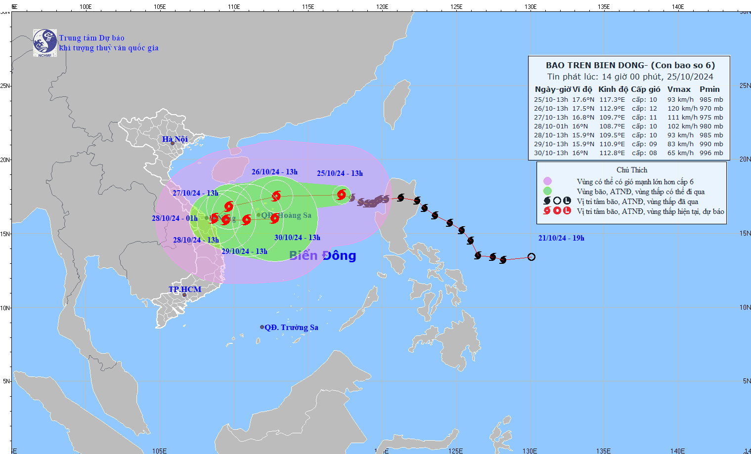
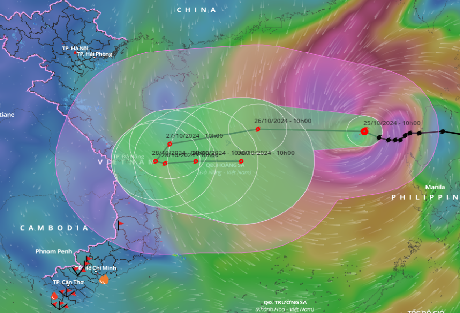
Storm No. 6, level 12, 560km from Hoang Sa archipelago At 1:00 p.m. on October 25, the eye of the storm was located in the eastern sea of the North East Sea, about 560 km east-northeast of the Hoang Sa archipelago. The strongest wind near the eye of the storm was level 10 (89-102 km/h), gusting to level 12. Moving in the West-Northwest direction, at a speed of 15-20 km/h. In the next 24 hours, the eye of the storm will be located in the Hoang Sa archipelago. The strongest wind near the eye of the storm is level 11-12, gusting to level 15. The storm will move west at a speed of about 20km/hour. At 1:00 p.m. on October 27, the eye of the storm was located in the western part of the Hoang Sa archipelago, about 180 km northeast of Quang Tri - Quang Ngai. The strongest wind near the eye of the storm was level 10-11, gusting to level 14. The storm moved in a West-Southwest direction at a speed of about 15 km/hour. At 1:00 p.m. on October 28, the eye of the storm was located in the coastal waters of the Central Central provinces. The strongest wind near the eye of the storm was level 10, gusting to level 12. The storm moved southwest, then east southeast, at a speed of about 5-10 km/hour. From the next 72 to 120 hours, the storm will move mainly to the East at 5-10km per hour, and its intensity will continue to weaken. Due to the influence of storm No. 6, the North East Sea has strong winds of level 8-9, near the storm's eye level 10-12 (89-133km/h), gusts of level 15, waves 5-7m high, near the storm's eye 7-9m; rough seas. From early morning on October 27, the seas of the provinces from Quang Binh to Quang Ngai (including Con Co and Ly Son island districts) have winds gradually increasing to level 6-7, then increasing to level 8-9, near the storm's eye level 10-11, gusts of level 14, waves 3-5m high, near the storm's eye 5-7m; rough seas. Ships operating in the above-mentioned dangerous areas (especially in the Hoang Sa island district) are likely to be affected by storms, whirlwinds, strong winds, and big waves. |
Why does storm number 6 have a 'strange' direction?
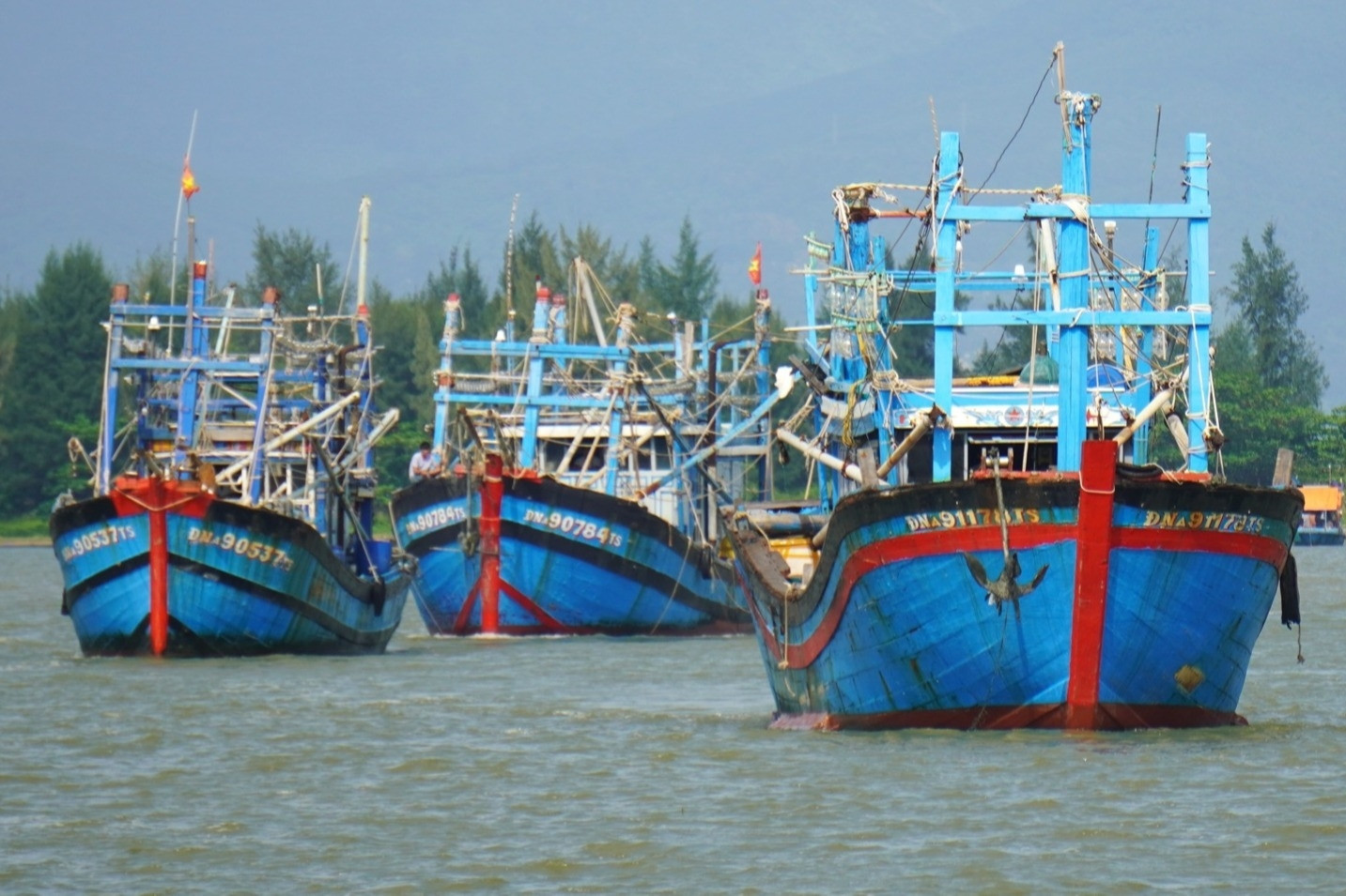
Storm Tra Mi intensifies, fishing boats in the Central region rush to shore
Source: https://vietnamnet.vn/bao-so-6-bao-tra-mi-kha-nang-tien-sat-bo-bien-mien-trung-2335501.html

![[Photo] Magical moment of double five-colored clouds on Ba Den mountain on the day of the Buddha's relic procession](https://vphoto.vietnam.vn/thumb/1200x675/vietnam/resource/IMAGE/2025/5/9/7a710556965c413397f9e38ac9708d2f)
![[Photo] Russian military power on display at parade celebrating 80 years of victory over fascism](https://vphoto.vietnam.vn/thumb/1200x675/vietnam/resource/IMAGE/2025/5/9/ce054c3a71b74b1da3be310973aebcfd)
![[Photo] General Secretary To Lam and international leaders attend the parade celebrating the 80th anniversary of the victory over fascism in Russia](https://vphoto.vietnam.vn/thumb/1200x675/vietnam/resource/IMAGE/2025/5/9/4ec77ed7629a45c79d6e8aa952f20dd3)
![[Photo] Prime Minister Pham Minh Chinh chairs a special Government meeting on the arrangement of administrative units at all levels.](https://vphoto.vietnam.vn/thumb/1200x675/vietnam/resource/IMAGE/2025/5/9/6a22e6a997424870abfb39817bb9bb6c)


Comment (0)