
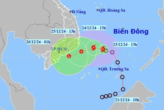
The tropical depression in the sea northwest of Truong Sa archipelago has strengthened into storm No. 10 (international name: Pabuk).
On the afternoon of December 23, the National Center for Hydro-Meteorological Forecasting said that at 4 p.m., the center of storm No. 10 was located at about 11.3 degrees North latitude; 112.4 degrees East longitude, in the northwest area of Truong Sa archipelago. The strongest wind near the center of the storm is level 8 (62-74 km/h), gusting to level 10; moving in the West Northwest direction, speed 5-10 km/h.
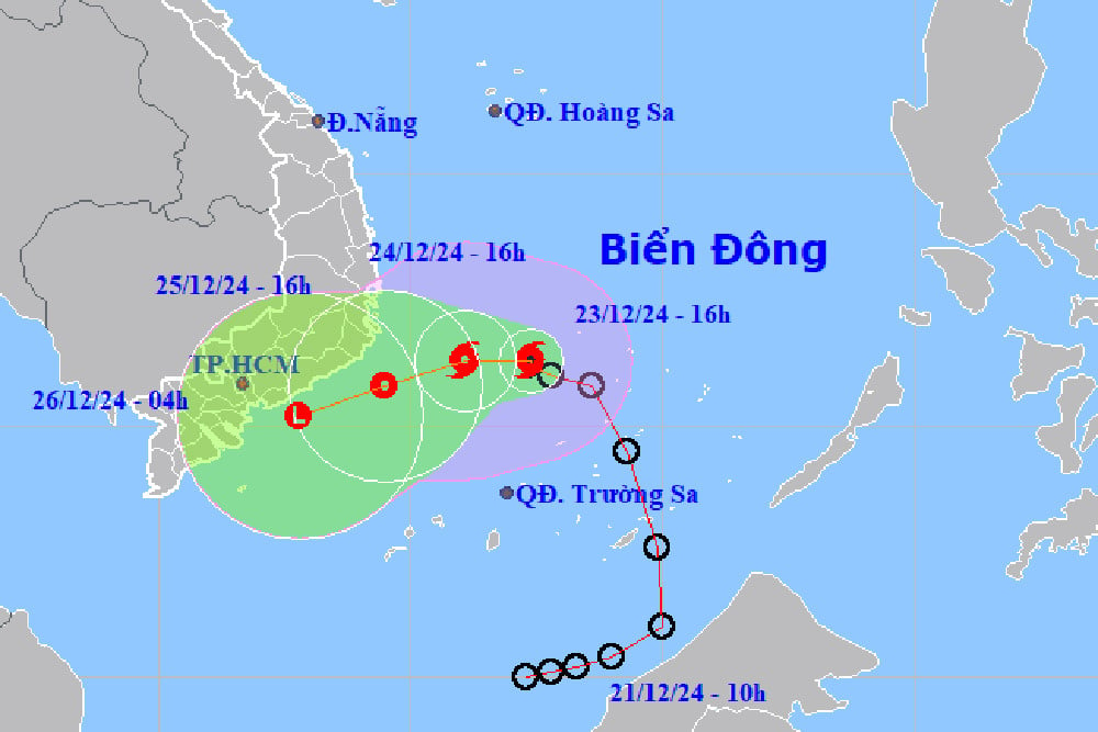
In the next 24 hours, the storm will continue to move slowly in a westerly direction. By 4:00 p.m. tomorrow (December 24), the storm's eye will be in the southwest sea area of the Central East Sea. The strongest wind near the storm's eye is level 8, gusting to level 10.
It is forecasted that in the next 24 hours, the storm will change direction to West Southwest, maintain a speed of about 5-10 km/h and gradually weaken into a tropical depression. At 4:00 p.m. on December 25, the center of the tropical depression over the sea from Phu Yen to Ba Ria - Vung Tau will be at level 6, gusting to level 8.
About 12 hours later, the tropical depression continued to weaken into a low pressure area over the sea from Binh Thuan to Tra Vinh.
Although this is not a strong storm, it causes bad weather for provinces from the Central Central region to the South and the Central Highlands.
Heavy rain from Central Central to Central Highlands and South
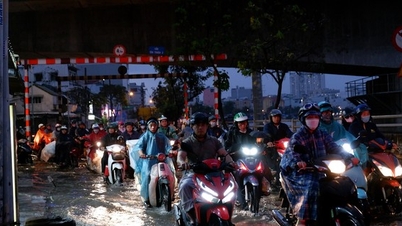
The meteorological agency warned of heavy rains caused by storm No. 10, which weakened into a tropical depression in the coastal provinces of the Central Central region to the South, causing many provinces and cities to have heavy rain for 2-3 days.
Specifically, today, in the Central Central region, there has been rain and showers. From tonight until December 25, from Da Nang to Khanh Hoa, there will be moderate rain, heavy rain, locally very heavy rain and thunderstorms with rainfall from 60-150mm, locally over 250mm. Warning of the risk of local heavy rain (>100mm/6 hours).
In addition, from early morning to tomorrow night (December 24), Ninh Thuan , Binh Thuan and the eastern part of the Central Highlands will have moderate rain and scattered thunderstorms, locally heavy rain, with rainfall from 20-40mm, some places over 80mm.
It is forecasted that on the night of December 25, heavy rain will continue in the Central Central region with rainfall of 20-40mm, locally over 70mm. From December 26, heavy rain is likely to gradually decrease. During thunderstorms, there is a possibility of tornadoes, lightning and strong gusts of wind.
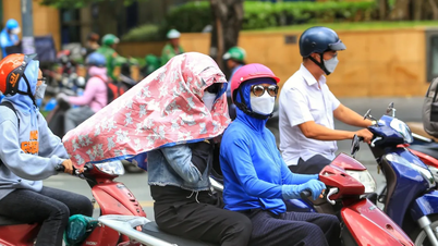
In addition, the Southern Hydrometeorological Station also forecasts that the weather in the South will be cloudy, sunny during the day, with scattered showers in the evening, moderate rain in some places, heavy rain and thunderstorms in some places.
In Ho Chi Minh City, the weather is cloudy, sunny during the day, no rain at night; light fog in the early morning; showers and thunderstorms in some places in the late afternoon and evening.
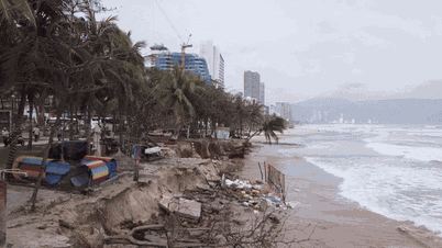
Impact of storm No. 10, the sea area northwest of the South East Sea (including the sea area northwest of Truong Sa archipelago) and the sea area southwest of the Central East Sea have strong winds of level 6-7, the area near the storm center has strong winds of level 8, gusts of level 10, waves 4-6m high; rough seas. The sea area from Phu Yen to Ba Ria - Vung Tau (including Phu Quy island) has strong winds of level 6, sometimes level 7, gusts of level 8-9, waves 3-6m high; rough seas. Ships operating in the above mentioned dangerous areas are susceptible to the effects of storms, whirlwinds, strong winds and large waves. |
Storm No. 10 formed in the East Sea, international name is Pabuk
The tropical depression has strengthened into a storm, storm number 10, internationally named Pabuk; with wind gusts of level 10 in the sea northwest of Truong Sa archipelago. The storm is forecast to head towards the South Central and Southern seas.

![[Photo] Special flag-raising ceremony to celebrate the 135th birthday of President Ho Chi Minh](https://vphoto.vietnam.vn/thumb/1200x675/vietnam/resource/IMAGE/2025/5/19/1c5ec80249cc4ef3a5226e366e7e58f1)


![[Photo] Party and State leaders visit President Ho Chi Minh's Mausoleum](https://vphoto.vietnam.vn/thumb/1200x675/vietnam/resource/IMAGE/2025/5/19/d7e02f242af84752902b22a7208674ac)


![[VIDEO] - Enhancing the value of Quang Nam OCOP products through trade connections](https://vphoto.vietnam.vn/thumb/402x226/vietnam/resource/IMAGE/2025/5/17/5be5b5fff1f14914986fad159097a677)


Comment (0)