
On the afternoon of August 30, the latest information from the National Center for Hydro-Meteorological Forecasting said that at 4:00 p.m., the center of storm No. 3 was located at about 20.5 degrees north latitude; 119.8 degrees east longitude, in the northeastern sea of the North East Sea.
The strongest wind near the storm center is level 15-16 (167-201km/h), gusting over level 17, moving in the West Northwest direction, speed about 15km/h.
Speaking to VietNamNet reporter , Dr. Hoang Phuc Lam, Deputy Director of the Forecasting Center, said: " Storm Saola entered the East Sea, officially becoming the third storm in the East Sea in 2023."
However, Mr. Lam commented: "Although the storm is moving west, the possibility of causing strong winds and heavy rain for Vietnam's mainland and coastal areas is very small."
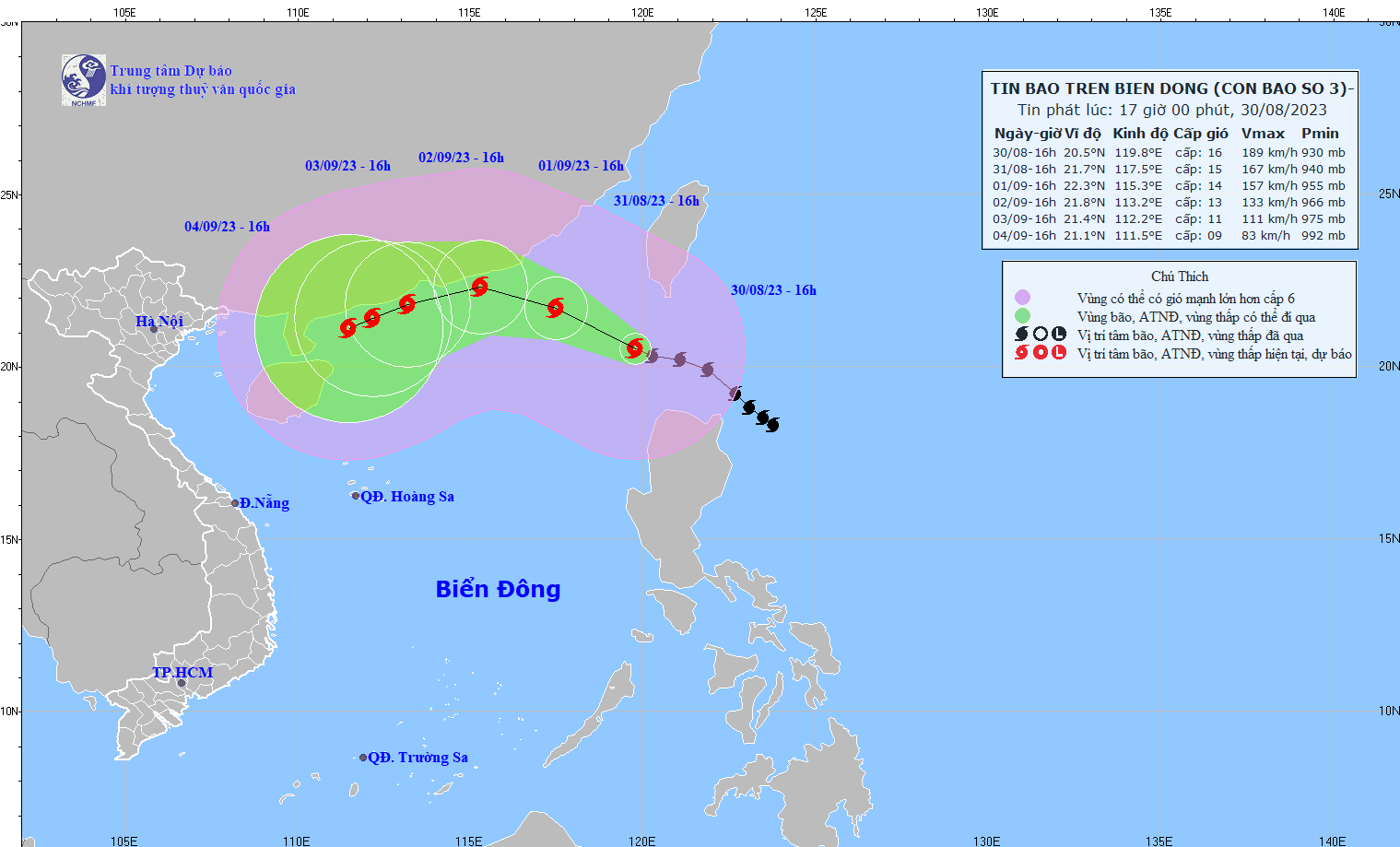
According to the meteorological agency, in the next 24 hours, storm No. 3 will move in the West-Northwest direction at a speed of 10-15 km/h. At this time, the center of the storm is located at about 21.7 degrees north latitude - 117.5 degrees east longitude; in the northeastern sea area of the North East Sea, about 370 km east-southeast of Hong Kong (China).
The strongest wind near the storm center is level 15, gusting over level 17. The dangerous area due to storm number 3 is north of latitude 17.5; east of longitude 115.0.
In the next 48 hours, storm No. 3 will maintain its direction of movement and its speed will decrease to about 10 km/h. At 4:00 p.m. on September 1, the center of the storm will be located in the northern sea area of the North East Sea, about 100 km east-southeast of Hong Kong (China). The strongest wind near the center of the storm will decrease to level 14, gusting to level 17.
In the next 72 hours, storm No. 3 will change direction to West Southwest at a speed of about 10km/h. The center of the storm is located in the sea of Guangdong (China). The strongest wind near the center of the storm will continue to decrease to level 12-13, gusting to level 16.
From the next 72 to 120 hours, the storm will move mainly in the West Southwest direction, traveling 5-10km per hour, with the intensity likely to gradually decrease.
Regarding the impact of storm No. 3, the northeastern sea area of the North East Sea has strong storm winds of level 9-10, later increasing to level 11-13, near the storm center level 14-16, gusting above level 17; the sea is very rough. The eastern sea area of the North East Sea has waves 4-6m high, later increasing to 8-10m.
Source
![[Photo] Prime Minister Pham Minh Chinh works with the Standing Committee of Thai Binh Provincial Party Committee](https://vphoto.vietnam.vn/thumb/1200x675/vietnam/resource/IMAGE/2025/5/12/f514ab990c544e05a446f77bba59c7d1)


![[Photo] Prime Minister Pham Minh Chinh starts construction of vital highway through Thai Binh and Nam Dinh](https://vphoto.vietnam.vn/thumb/1200x675/vietnam/resource/IMAGE/2025/5/12/52d98584ccea4c8dbf7c7f7484433af5)
![[Photo] Prime Minister Pham Minh Chinh receives Swedish Minister of International Development Cooperation and Foreign Trade](https://vphoto.vietnam.vn/thumb/1200x675/vietnam/resource/IMAGE/2025/5/12/ae50d0bb57584fd1bbe1cd77d9ad6d97)


Comment (0)