
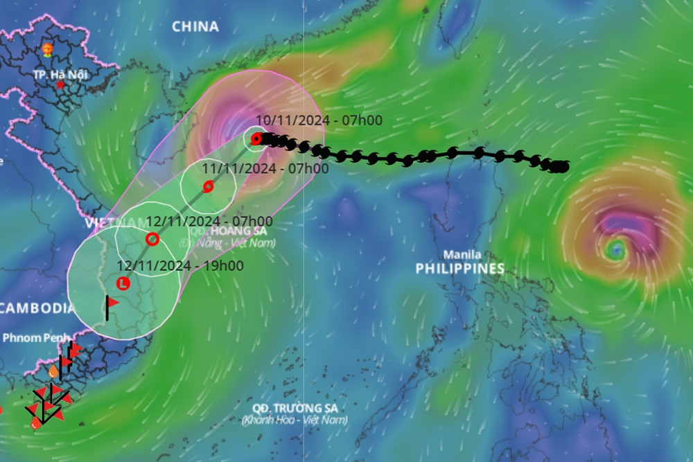
Typhoon No. 7 Yinxing is weakening rapidly. Typhoon Toraji is about to enter the East Sea and become Typhoon No. 8. There is a gap between the two typhoons, and Typhoon Toraji will cause Typhoon No. 7 to shift further south.
Mr. Nguyen Van Huong, Head of Weather Forecast Department, National Center for Hydro-Meteorological Forecasting, has just shared about the developments of storm No. 7 and the trend of natural disasters in the East Sea in the coming days.
Accordingly, a tropical depression in the eastern region of the Philippines strengthened into a storm with the international name Yinxing (the 22nd storm in the Northwest Pacific Ocean), on the morning of November 4.
By the afternoon of November 7, Typhoon Yinxing made landfall in the eastern part of the Philippines and early the next morning moved into the East Sea, becoming typhoon number 7.
Since entering the East Sea, storm No. 7 Yinxing has maintained a level 14 intensity, gusting to level 17. By the afternoon of November 9, storm No. 7 had its strongest intensity at level 14-15. After that, from the night of the same day, the storm stabilized and by early this morning (November 10), it changed direction to move south, its intensity rapidly decreasing.
Mr. Huong explained the environmental conditions affecting the direction and intensity of storm No. 7.
Specifically, since last night until now, storm No. 7 has moved into an area with unfavorable environmental conditions for the development of the storm. Firstly, the current sea surface temperature in the western area of the Hoang Sa archipelago is below the optimal level (below 26 degrees), reducing the energy supply for the storm, contributing to its gradual weakening.
Second, cold and dry air masses still prevail, so the relative humidity in the atmosphere from the ground to an altitude of 1,500m is very low, limiting the development of storm clouds.
In addition, there is currently a new storm, internationally named Toraji, active in the eastern part of the Philippines. It is forecasted that tomorrow morning (November 11), when moving into the eastern part of Luzon Island (Philippines), the distance between the two storms will be about 1,200-1,400km, which is the distance at which the interaction of two storms occurs. Storm Toraji will cause storm No. 7 Yinxing to shift further south.
Rough seas, rain in Central and South Central regions
Mr. Huong said that at 11:00 a.m. on November 10, in the next 24-48 hours, the storm will continue to move southwest and its intensity will rapidly decrease to below level 10 due to unfavorable conditions of temperature and humidity as mentioned above.
Due to the impact of storm No. 7, the western sea area of the North East Sea has strong winds of level 7-9, near the storm's eye level 10-13, gusting to level 16, waves 4-6m high, near the eye 6-8m; the sea is very rough.
From early tomorrow morning, the sea area from Quang Tri to Quang Ngai will have strong winds of level 6-7, near the eye of the storm will be strong winds of level 8, gusts of level 10, waves of 2-4m high, near the eye of the storm 3-5m; rough seas. Ships operating in the above-mentioned dangerous areas are likely to be affected by storms, whirlwinds, strong winds, and big waves.
On land, due to the influence of storm No. 7, from tomorrow evening and night until the end of November 12, there will be rain in the Central and South Central regions, but there is very little possibility of extreme rain causing flooding on rivers in the Central region.
However, Mr. Huong also noted that these are warnings based on current data, people in the coastal areas of the Central region, especially from Quang Tri to Quang Ngai, need to closely monitor the storm situation and prepare response plans to minimize risks.
Very bad weather in the East Sea
Mr. Huong informed that in the eastern part of the Philippines, there are currently 2 storms and 1 tropical depression active. Storm Toraji is likely to move into the East Sea from the evening to tomorrow night (November 11), so after storm number 7, storm number 8 will appear.
Under the impact of storm number 7 and then storm number 8, the northern and central regions of the East Sea will continue to have bad weather days with strong winds, high waves and rough seas in the coming time.
The Center continues to monitor and update further developments.
Responding to weather developments at sea, the Minister of Agriculture and Rural Development has just sent a telegram to the People's Committees of coastal provinces and cities from Quang Ninh to Binh Thuan to proactively respond to storm developments.
Typhoon Toraji nears the East Sea, likely to become typhoon number 8

![[Photo] President Luong Cuong presents the decision to appoint Deputy Head of the Office of the President](https://vphoto.vietnam.vn/thumb/1200x675/vietnam/resource/IMAGE/2025/5/8/501f8ee192f3476ab9f7579c57b423ad)

![[Photo] General Secretary concludes visit to Azerbaijan, departs for visit to Russian Federation](https://vphoto.vietnam.vn/thumb/1200x675/vietnam/resource/IMAGE/2025/5/8/7a135ad280314b66917ad278ce0e26fa)
![[Photo] General Secretary To Lam begins official visit to Russia and attends the 80th Anniversary of Victory over Fascism](https://vphoto.vietnam.vn/thumb/1200x675/vietnam/resource/IMAGE/2025/5/8/5d2566d7f67d4a1e9b88bc677831ec9d)
![[Photo] Prime Minister Pham Minh Chinh meets with the Policy Advisory Council on Private Economic Development](https://vphoto.vietnam.vn/thumb/1200x675/vietnam/resource/IMAGE/2025/5/8/387da60b85cc489ab2aed8442fc3b14a)
![[Photo] National Assembly Chairman Tran Thanh Man chairs the meeting of the Subcommittee on Documents of the First National Assembly Party Congress](https://vphoto.vietnam.vn/thumb/1200x675/vietnam/resource/IMAGE/2025/5/8/72b19a73d94a4affab411fd8c87f4f8d)


![[Photo] Prime Minister Pham Minh Chinh talks on the phone with Singaporean Prime Minister Lawrence Wong](https://vphoto.vietnam.vn/thumb/402x226/vietnam/resource/IMAGE/2025/5/8/e2eab082d9bc4fc4a360b28fa0ab94de)


Comment (0)