
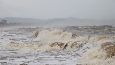
TPO – The Meteorological Agency forecasts that today (September 19), the weather in Ho Chi Minh City and the southern provinces and cities will be cloudy, with showers and thunderstorms in many places, scattered moderate rain, heavy rain in some places, and very heavy rain in some places.
According to the Southern Hydrometeorological Station, in the past 24 hours, there was rain in many places in Ho Chi Minh City, scattered heavy rain. The rainfall in the past 24 hours is as follows: Cu Chi 84.2mm, Thu Duc 78mm, Pham Van Coi - Cu Chi 55.8mm, Can Gio 53.8mm, Hoc Mon 51.4mm, Le Minh Xuan - Binh Chanh 44.2mm, Tam Thon Hiep - Can Gio 41.6mm, Nha Be 39.2mm, An Phu - Cu Chi 39.0mm, Cat Lai 29.8mm, Binh Chanh 27.4mm, ...
It is forecasted that from September 19 to September 21, Ho Chi Minh City will have moderate to heavy rain. Total rainfall will range from 50-90mm, with some places over 100mm.
 |
Detailed forecast of total rainfall in areas of Ho Chi Minh City from September 19 to 21. Source: Southern Hydrometeorological Station |
“The heavy rain in Ho Chi Minh City is likely to last until September 21. During thunderstorms, there is a possibility of tornadoes, lightning and strong gusts of wind. Beware of the possibility of heavy rain causing flooding in low-lying areas, along rivers and canals,” said the Southern Hydrometeorological Station.
 |
Heavy rain caused flooding on many streets in Ho Chi Minh City on September 18. Photo: Huu Huy |
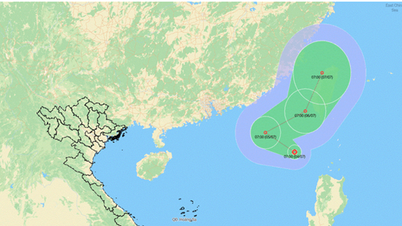
Also according to the Southern Hydrometeorological Station, early this morning (September 19), the tropical depression in the northeastern area of Hoang Sa archipelago strengthened into a storm (storm number 4 in 2024).
At 4:00 a.m. on September 19, the center of the storm was at approximately 17.3 degrees North latitude; 109.8 degrees East longitude, approximately 210 km northeast of Da Nang and 260 km east of Quang Tri. The strongest wind near the center of the storm was level 8 (62-74 km/h), gusting to level 10. The storm moved mainly westward at a speed of approximately 20 km/h.
The western sea area of the North East Sea (including the Hoang Sa archipelago), the sea area from Nghe An to Quang Ngai (including the island districts of Ly Son, Cu Lao Cham, Con Co, Hon Ngu) has strong winds of level 6-7 (39-61 km/h), waves 2-4m high, the area near the storm center has level 8 (62-74 km/h), gusts of level 10 (89-102 km/h), waves 3-5m high, rough seas.
In addition, due to the influence of the strong southwest monsoon, in the sea area from Ba Ria-Vung Tau to Ca Mau (including the sea area of Ho Chi Minh City), there is a southwest wind level 6, sometimes level 7, gusting to level 8-9. Wave height 2.5-4.5m. The sea area from Ca Mau to Kien Giang and the Gulf of Thailand has a southwest wind level 5, sometimes level 6, gusting to level 7-8. Wave height 1.5-3.0m. In both sea areas, there are showers and thunderstorms, during thunderstorms, beware of strong gusts and whirlwinds.
The weather in the southern provinces and cities is affected by the tropical convergence zone with an axis through the Central region connecting with storm No. 4. At the same time, the southwest monsoon (causing rain) is operating with strong intensity. Therefore, today (September 19), the weather in the southern provinces and cities is cloudy, sometimes less cloudy and sunny during the day, with showers in many places, scattered moderate rain and thunderstorms, heavy rain in some places, locally very heavy rain. During thunderstorms, be on guard against whirlwinds, lightning and strong gusts of wind.


Comment (0)