Jean-Baptist Taberd (Vietnamese name is Tu) was born in Saint-Etienne, Loire district (France) on June 18, 1794. Taberd joined the Society for Foreign Missions, headquartered in Paris (MEP), and was ordained a priest on July 27, 1817. On November 7, 1820, he left France for Dang Trong - Vietnam to evangelize. Taberd made an effort to learn to speak Vietnamese and write in Chinese - Nom - Latin scripts, and the best learning material was probably the Annam Latin Dictionary of Bishop Pigneau de Behaine. Taberd was mainly concerned with training native priests.
The 1788 map has the line “R. de Saigon” [Saigon River]
Photo: National Library of France
At the end of 1827, Gia Dinh Governor Le Van Duyet returned to the capital to pay homage to Minh Mang. Taberd met him twice. In March of the following year (1828), when Le Van Duyet returned to his post, on June 1, the three missionaries Taberd, Gagelin, and Odoric were allowed to leave Hue and enter Gia Dinh.
GRAPHIC MAP FULLY RECORDING PLACE NAMES IN CONTEMPORARY VIETNAM
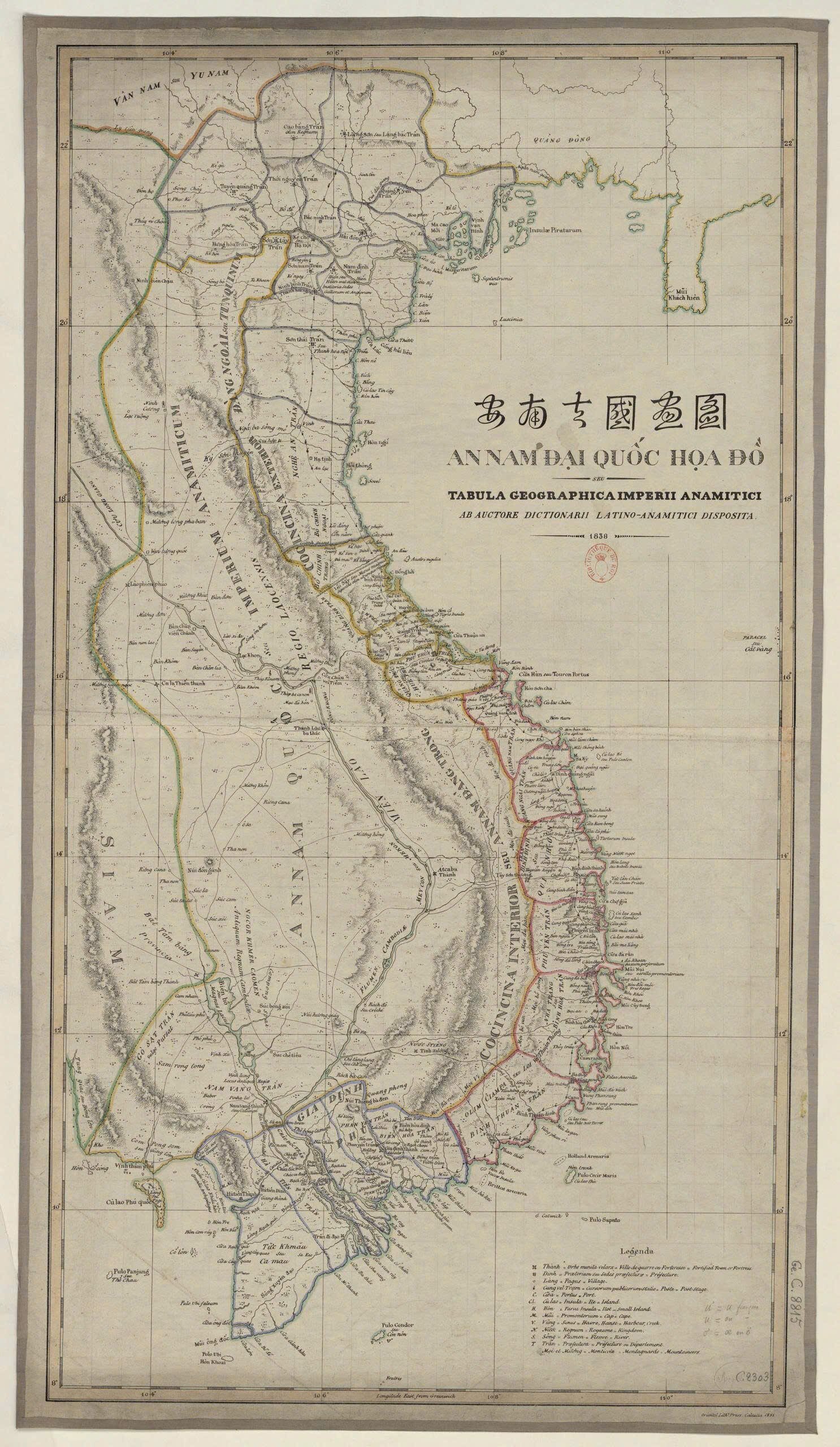
Map of An Nam Dai Quoc Hoa Do ( ANĐQHĐ ) - a unique work of Taberd. Up to the time of publication in 1838, our country had never had a map as large and comprehensive as this one. Let's analyze and compare it with the map of Dai Nam Nhat Thong Toan Do (ĐNNTTD) (1840), an official map of the Minh Mang dynasty.
The place names on the 1838 Taberd map are all written in Chinese, while the ANĐQHĐ map is written in the Latin national language, both administrative and common names, plus the names given by foreigners. For example: Thach Bi Mountain (in Chinese) is commonly known as Mui Nai (Nom) and is called Cap Varella in the West.

Bishop Bá Đa Lộc – author of the Annamese Latin Dictionary, a document that helped Taberd a lot in his self-study in Vietnam.
In particular, the 1838 Taberd map recorded about 505 place names in Latin or Vietnamese. In the middle of the map, Taberd wrote in large letters: An Nam country seu (or) Imperium Anamiticum. The whole of Vietnam at that time was divided into: Gia Dinh prefecture (later Nam Ky), Cocincina interior seu (or) An Nam Dang Trong, Cocincina exterior seu (or) Dang Ngoai or Tunquinum.
Taberd explained that citadel was a military defensive citadel and did not care about citadel, which also meant an administrative unit consisting of many towns, such as Gia Dinh citadel or Bac citadel. The map shows: Binh Dinh citadel, Binh Hoa citadel (near Nha Trang), Gia Dinh citadel (Saigon). Taberd explained that dinh was the administrative headquarters of a town. In fact, in Dang Trong, dinh was an administrative unit later called a town and then a province. Therefore, in the map, for the towns of Dang Ngoai from Bo Chinh outwards, Taberd only recorded the town name. As for the towns of Dang Trong, he recorded both the town name and the location of the dinh name. The number of towns in Taberd's map was also almost equivalent to the number of provinces in the Central Highlands , except for Bo Chinh Ngoai, which now belongs to Ha Tinh province, Bo Chinh Trong was returned to Quang Binh province and Quang Duc town was changed to Thua Thien prefecture. Vinh Thanh town was changed to two provinces Vinh Long and An Giang.
Regarding the supply and stations on the national highways and the dependent regions, Taberd was the first person to draw them on the most complete map. That was the main highway from Nam Quan - Lang Son, through Hanoi, Hue and to Gia Dinh citadel, also known as Saigon. There were also secondary highways: the road to Hanoi through Hai Dong (Hai Duong), Quang Yen then around to Lang Son and Cao Bang; the road from Hanoi through Thai Nguyen to Cao Bang, with an additional branch going from Thai Nguyen to Lang Son...
In the Central region, from the national highway in Vinh, there is a road crossing the Truong Son mountain range, reaching Quy Hop and dividing into two branches: one branch passes through Ky Son, and the second branch goes through Co Thai pass, Ban Don, Lao Xi Da, crossing to the right bank of the Mekong river to Lac Khon...
In the South, there is a road from Gia Dinh citadel through Lai Thieu to Ba Den mountain, which is divided into two directions: one going west to Nam Vang, and the other going north to Che Tang Lang. There is also a road from Ha Tien citadel to Nam Vang citadel. From Nam Vang, there are many roads to Com Pong Som, to Bat Tam Bang...
The continental shelf and the East Sea are the most concentrated with place names: names of estuaries, capes, lagoons, islands, and islets are very rich and accurate. Taberd recorded the historical geography of Dang Trong more thoroughly than Dang Ngoai (the number of place names is richer). Gia Dinh Prefecture, which covers the entire Southern region, was converted into Gia Dinh Town in 1802, but Taberd still recorded the old administrative form.
Regarding the map format, Taberd drew according to Western maps with correct longitude and latitude. But when recording place names, Taberd used official documents of Vietnam. He mostly transcribed from Han Nom into the Latin language of the maps provided by the National History Institute at that time. He also recorded place names that foreigners had given before they knew the actual names of our places.
With the archipelago in the middle of the East Sea having the administrative name Hoang Sa (Chinese characters), Taberd recorded the common name Cat Vang (Nom) which Westerners called Paracel. The place name Cat Vang is a Vietnamese word that only exists in ancient Dai Viet and present Vietnam, and cannot be found anywhere else.
Although there were some minor errors in the recording of place names, such as Long Xuyen Dao becoming Song Xuyen Dao, or Xuong Tinh (Nuoc Stieng) becoming Tinh Xuong, Bishop Taberd's map truly had a historical value that no contemporary map could match. ( continued ).
(Excerpt from Miscellaneous Notes on Vietnamese History and Geography by the late scholar Nguyen Dinh Dau published by Tre Publishing House)
Source: https://thanhnien.vn/gia-tri-vo-gia-cua-ban-do-taberd-1838-185241008215439532.htm















Comment (0)