
 |
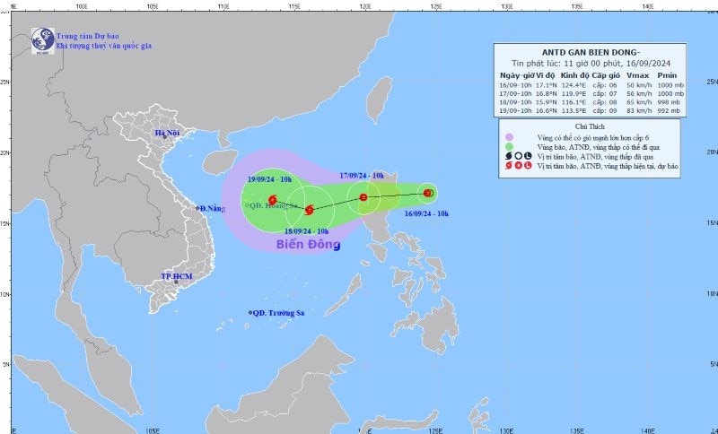
| Direction of the tropical depression. Photo: Center for Hydro-meteorological Forecasting |
According to the National Center for Hydro-Meteorological Forecasting, a tropical depression is currently active in the sea east of Luzon Island (Philippines). At 10:00 a.m. on September 16, the center of the tropical depression was at about 17.1 degrees North latitude; 124.4 degrees East longitude. The strongest wind near the center of the tropical depression is level 6-7 (39-61 km/h), gusting to level 9; moving mainly west at about 15 km/h.
Forecast at 10am on September 17, the center of the tropical depression is at about 16.8 degrees North latitude; 119.9 degrees East longitude. The strongest wind near the center of the tropical depression is level 7, gusting to level 9; moving mainly west at about 15-20 km/h, moving into the East Sea.
At 10:00 a.m. on September 18, the center of the tropical depression was at about 15.9 degrees North latitude; 116.1 degrees East longitude. The strongest wind near the center of the tropical depression was level 8, gusting to level 10; moving mainly in the West Southwest direction at about 20 km/h, strengthening into a storm.
In the next 48 to 72 hours, the storm is likely to change direction, moving in the West Northwest direction, traveling 10-15km per hour.
Due to the impact of a tropical depression, from the morning of September 17, the eastern sea area of the North East Sea will have showers and thunderstorms, strong winds of level 7 (50-61km/h), gusts of level 9 (75-88km/h), and rough seas.
The eastern sea area of the North East Sea has waves 2.0-4.0m high.
The National Center for Hydro-Meteorological Forecasting said: Currently, in the Gulf of Tonkin, the sea area from Quang Tri to Ca Mau, Ca Mau to Kien Giang , the Gulf of Thailand, the eastern sea area of the northern East Sea, the central and southern East Sea (including the sea area of Truong Sa archipelago) there are showers and thunderstorms. During thunderstorms, there is a possibility of tornadoes and strong gusts of wind of level 7-8.
Currently, the tide level in the western coastal area of the South is high, it is necessary to guard against abnormal water level rise causing sea dike erosion.
On September 17, the sea area from Ninh Thuan to Ca Mau, the northern East Sea area (including the Hoang Sa archipelago), the southern sea area between the East Sea and the southern East Sea area (including the Truong Sa archipelago) will have strong southwest winds of level 6, sometimes level 7, gusting to level 8-9, rough seas; waves 3-5 m high./.


![[Photo] Unique architecture of the deepest metro station in France](https://vphoto.vietnam.vn/thumb/1200x675/vietnam/resource/IMAGE/2025/11/14/1763107592365_ga-sau-nhat-nuoc-phap-duy-1-6403-jpg.webp)


![[Photo] Special class in Tra Linh](https://vphoto.vietnam.vn/thumb/1200x675/vietnam/resource/IMAGE/2025/11/14/1763078485441_ndo_br_lop-hoc-7-jpg.webp)
![[Photo] Unique art of painting Tuong masks](https://vphoto.vietnam.vn/thumb/1200x675/vietnam/resource/IMAGE/2025/11/14/1763094089301_ndo_br_1-jpg.webp)


Comment (0)