On February 21, 2025, the Government issued a Declaration on the baselines used to calculate the width of Vietnam's territorial waters in the Gulf of Tonkin, marking that from now on, Vietnam's baselines will be officially completed from North to South.
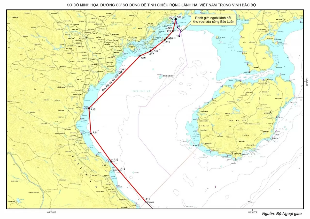 |
| Declaration on baselines used to calculate the breadth of Vietnam's territorial waters in the Gulf of Tonkin. |
On February 21, 2025, the Government issued a Declaration on the baselines used to calculate the width of Vietnam's territorial waters in the Gulf of Tonkin, marking that from now on, Vietnam's baselines have been officially completed from North to South, from the Bac Luan River mouth adjacent to China to Point 0 located on the southwestern boundary of the Vietnam - Cambodia historical waters.
The baseline used to calculate the breadth of Vietnam's territorial waters was first announced in the Government's Declaration of November 12, 1982. At that time, the baseline along the Vietnamese mainland coast was a straight baseline consisting of 11 segments, connecting Point 0, the junction point of the two baselines of Vietnam and Cambodia, in the middle of the straight line connecting the Tho Chu archipelago of Vietnam and Wai island of Cambodia, passing through the base points at the farthest protruding points of the coastal islands and coast of Vietnam to Point A11 on Con Co island, Quang Tri province. In the Declaration of February 21, 2025, the Government announced the remaining part of the baseline as the segment located in the Gulf of Tonkin.
Accordingly, the baseline continues to be connected from Point A11 at Con Co Island through the points of Hon Gio Lon (Point A12), Hon Chim (Point A13), Hon Mat Con (Point A14), Hon Me Island (Point A15), Long Chau Dong Island (Point A16), Ha Mai Island (Point A17, Point A18), Thanh Lam Island (Point A19, Point A20), Hon Bo Cat (Point A21, Point A22), Tra Co Island (Point A23) to Point A24, which is Point No. 1 of the demarcation line of the Gulf of Tonkin between Vietnam and China.
The baseline used to calculate the breadth of the territorial sea of Bach Long Vi Island is the normal baseline along the low-water line along the coast of the island; the outer boundary of the territorial sea in the Bac Luan estuary area is the line connecting 9 points along the territorial sea demarcation line in the Gulf of Tonkin between Vietnam and China and point 10 with coordinates determined in Vietnam's waters.
The Gulf of Tonkin is a semi-enclosed sea, with many places being divided, many areas with unstable geology, often subject to sedimentation, and changing seasonally. The Ha Long Bay area with 1,969 large and small islands interwoven, spread over a sea area of about 1,600km2 has created a special, very complex geographical situation.
Along the coast of the Gulf of Tonkin on the Vietnamese side, there are islands running along the coast (Hon Ong, Hon Chim, Hon Me...), the distance from these islands to the coast is less than 12 nautical miles and the consecutive distance between these islands is not too large, together with the small islands and rocks on the outermost part of Ha Long Bay, forming an island chain.
The waters within Ha Long Bay and the coastal islands of the Gulf of Tonkin are closely connected enough to form the internal waters of Vietnam. This natural condition of the Gulf of Tonkin meets the criteria stated in Article 7 of the 1982 United Nations Convention on the Law of the Sea (UNCLOS) on drawing straight baselines used to measure the breadth of the territorial sea.
Applying the provisions of Articles 5, 7 and 14 of UNCLOS 1982, considering the actual geographical situation of the Gulf of Tonkin, the Government of Vietnam has determined and announced the baseline used to calculate the breadth of Vietnam's territorial waters in the Gulf of Tonkin.
According to the above determination, this baseline with the base points determined at the outermost islands, running along the coast and not more than 12 nautical miles from the coast, closely follows the general shape of the coast of the Gulf of Tonkin and the baseline of Bach Long Vi island according to the lowest tide line around the island. Basically, this baseline is established in accordance with the provisions of UNCLOS 1982.
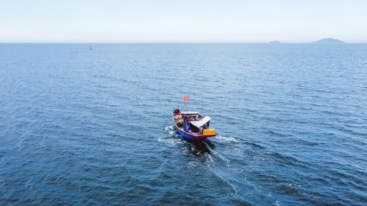 |
| Fishermen's fishing boats go out to sea on An Bang beach, Quang Nam province. (Source: bienphong) |
Determining and announcing the baseline used to calculate the width of Vietnam's territorial waters in the Gulf of Tonkin is necessary because the Government's Declaration dated November 12, 1982 only determined Vietnam's baseline from the historical waters of Vietnam - Cambodia to Con Co Island, and did not specify the baseline in the Gulf of Tonkin because at that time, the Gulf of Tonkin was considered a historical water area according to Vietnam's internal waters regime.
However, on December 25, 2000, Vietnam and China signed an Agreement on the delimitation of territorial waters, exclusive economic zones and continental shelves in the Gulf of Tonkin, in which both sides acknowledged that the Gulf of Tonkin has full maritime zones (internal waters, territorial waters, contiguous zones, exclusive economic zones and continental shelves) according to the provisions of UNCLOS 1982.
After this Agreement came into effect in 2004, the Gulf of Tonkin is no longer a historical water area under the internal waters regime as stated in the Government's Declaration on baselines used to calculate the breadth of territorial waters in 1982.
Therefore, Vietnam needs to determine the baseline in the Gulf of Tonkin as a basis for determining the outer boundaries of the sea areas in this area, creating a legal basis for the implementation of Vietnam's maritime activities in the Gulf of Tonkin.
The Vietnamese Government's determination and publication of the baseline used to calculate the breadth of Vietnam's territorial waters in the Gulf of Tonkin has met the above-mentioned necessary needs. This is a normal activity to exercise the rights of a coastal state under the provisions of UNCLOS 1982, of which Vietnam is a member.
This activity is also based on the provisions of Vietnamese law stated in Article 8 of the Law of the Sea of Vietnam: "The Government determines and announces baselines in areas where baselines are not available after being approved by the Standing Committee of the National Assembly".
For Vietnam, the determination and publication of the baselines used to calculate the breadth of the territorial waters in the Gulf of Tonkin is of great significance. This is the basis for determining the boundaries of internal waters, territorial waters, contiguous zones, exclusive economic zones and continental shelves that Vietnam enjoys in accordance with the provisions of international law, UNCLOS 1982; helping to further consolidate the legal basis for exercising Vietnam's sovereignty, sovereign rights and jurisdiction; ensuring Vietnam's rights and interests and not affecting the Agreement on the delimitation of territorial waters, exclusive economic zones and continental shelves in the Gulf of Tonkin between Vietnam and China as well as other international treaties to which Vietnam participates or is a member.
The announcement of baselines in the Gulf of Tonkin helps complete the entire baseline system used to calculate the breadth of the territorial waters of Vietnam's mainland territory, creating a legal basis for Vietnam's functional forces to carry out tasks of managing Vietnam's sea areas, including the Gulf of Tonkin area, contributing to the sustainable development of the marine economy and promoting international cooperation.
Thus, the Vietnamese Government's determination and announcement of the baseline used to calculate the breadth of the territorial waters in the Gulf of Tonkin is not only an exercise of the rights and obligations of a member state of UNCLOS 1982 but also an important basis for building and developing the Gulf of Tonkin into a safe, peaceful, cooperative and developing sea area.
 | Three AUKUS countries conduct joint exercises in the East Sea Last week, the navies of the United States, Australia and Britain - countries participating in the trilateral security pact AUKUS ... |
 | US increases reconnaissance flights in the East Sea, affirming its commitment to maintaining a free and open Indo-Pacific region According to the latest report from the South China Sea Strategic Situation Probing Initiative (SCSPI), the US has significantly increased... |
 | ASEAN Future Forum 2025: Unity, Inclusiveness and Resilience Amidst 'Immense Changes' Will Create ASEAN's Brand Value 'The ASEAN Future Forum will gradually create its mark, brand, be consolidated, shaped and promoted. Only then, ... |
 | Permanent Deputy Minister of Foreign Affairs Nguyen Minh Vu attends the 8th Indian Ocean Conference in Oman Permanent Deputy Minister Nguyen Minh Vu affirmed that the connection of seas and oceans is a fundamental pillar for peace ... |
 | Malaysian Prime Minister meets with the Sultan of Brunei: Discusses a series of regional issues, promotes early completion of COC on the East Sea The South China Sea dispute, the Myanmar crisis and intra-ASEAN trade were among the topics discussed by Malaysian Prime Minister Anwar Ibrahim and ... |
Source: https://baoquocte.vn/viet-nam-chinh-thuc-hoan-thien-toan-bo-duong-co-so-dung-de-tinh-chieu-rong-lanh-hai-viet-nam-tu-bac-xuong-nam-305169.html




![[Photo] Prime Minister Pham Minh Chinh chairs conference on anti-smuggling, trade fraud, and counterfeit goods](https://vphoto.vietnam.vn/thumb/1200x675/vietnam/resource/IMAGE/2025/5/14/6cd67667e99e4248b7d4f587fd21e37c)


























Comment (0)