
The application has assisted the Fire and Rescue Force in quickly handling several fires in the province. By accurately identifying the nearest water source, the time to reach the scene has been significantly shortened, improving the effectiveness of firefighting and rescue operations.
Currently, fire prevention and fighting (PCCC) is receiving attention and being promoted by all levels and sectors, and the application of digital technology to PCCC and rescue operations has become an urgent requirement.
In response to operational demands, officers from the Fire Prevention and Rescue Police Department ( Dien Bien Provincial Police) have developed the "Dien Bien Water Source Map" application to assist functional forces in quickly identifying and accessing water sources for firefighting.
"Dien Bien Water Resources Map" is an application developed since 2023, completed in two weeks, with the main goal of providing detailed information about water sources usable for firefighting in the province. The data was collected from the field, including fire hydrants, water tanks, ponds, lakes, rivers, and streams.
This information is integrated into a digital map, making it easy for firefighters to look up and plan the fastest response. This is a completely free software, circulated internally within the Fire and Rescue Police Department to support professional work.
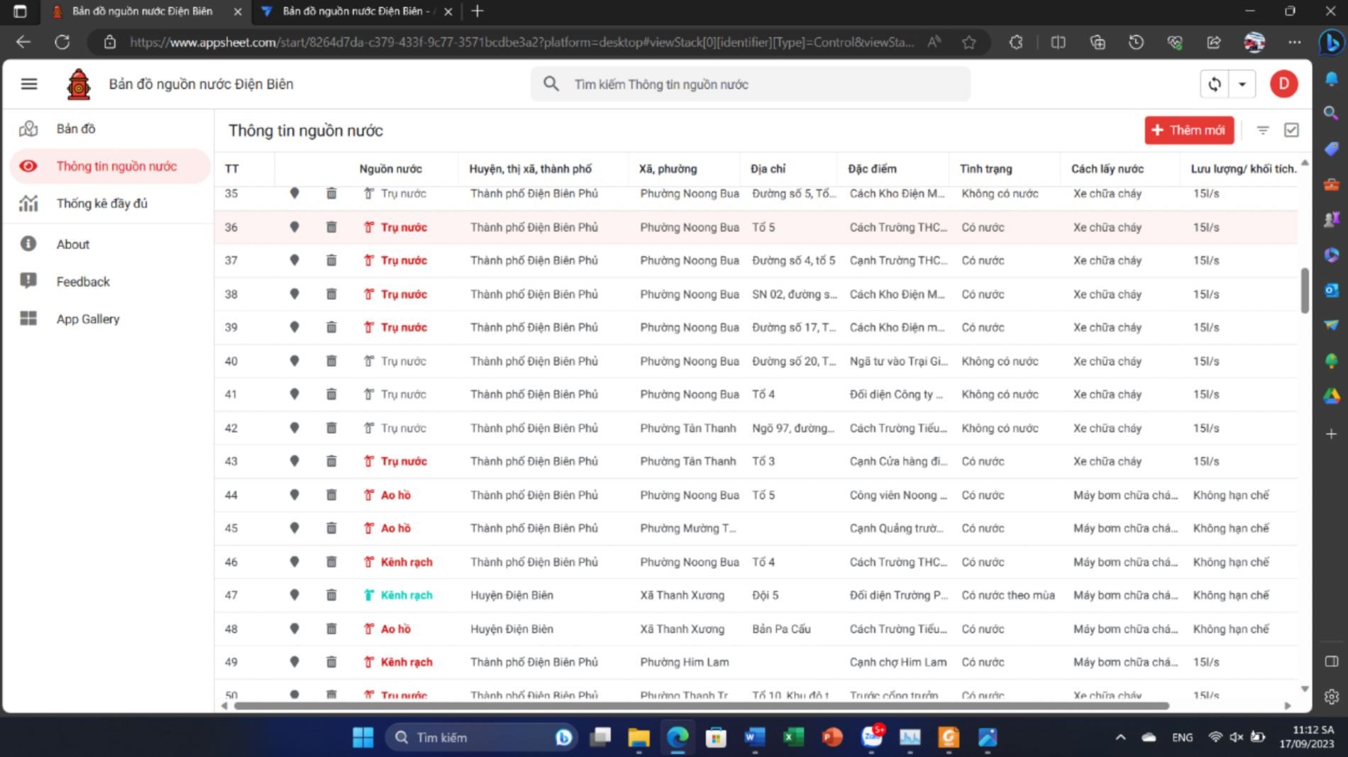
In addition, the application supports navigation features, helping firefighters reach water supply locations as quickly as possible. The Dien Bien water resource map also supports the planning and investment development of urban systems, ensuring a more synchronized and effective fire fighting water supply infrastructure.

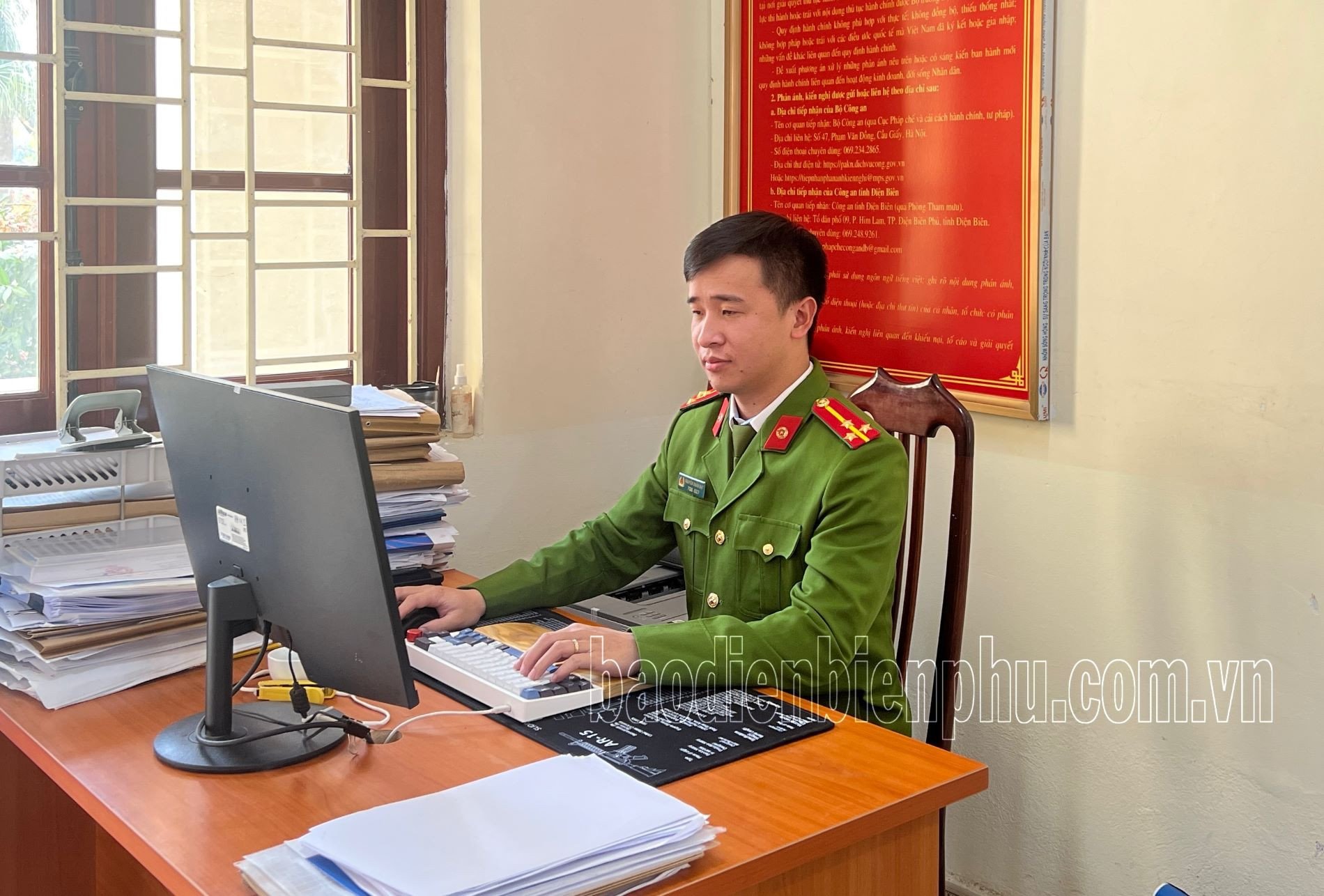
The "father" of the application, Senior Lieutenant Nguyen Doan Dat, an officer from the Fire Prevention and Rescue Department, shared: "I hope this application will help the fire fighting force shorten the time to access water sources, improve the efficiency of fire fighting and rescue, and support the scientific planning of fire prevention infrastructure. Practical implementation has shown that the application has proven effective, helping officers and soldiers be more proactive in fire fighting, minimizing damage to people and property."
After being put into trial, the application has assisted the Fire and Rescue Force in quickly handling several fires in the province. By accurately identifying the nearest water source, the time to reach the scene has been significantly shortened, improving the efficiency of firefighting and rescue operations. The application software helps unit leaders easily monitor and assess the water source situation, thereby making proposals for planning the addition of fire hydrants in areas lacking them.
According to Thu Thao (Dien Bien Phu Newspaper)
Source: https://vietnamnet.vn/ung-dung-cong-nghe-so-trong-chua-chay-va-cuu-nan-cuu-ho-2373603.html

![[Photo] Prime Minister Pham Minh Chinh receives the Governor of Tochigi Province (Japan)](/_next/image?url=https%3A%2F%2Fvphoto.vietnam.vn%2Fthumb%2F1200x675%2Fvietnam%2Fresource%2FIMAGE%2F2025%2F12%2F16%2F1765892133176_dsc-8082-6425-jpg.webp&w=3840&q=75)
![[Live] 2025 Community Action Awards Gala](/_next/image?url=https%3A%2F%2Fvphoto.vietnam.vn%2Fthumb%2F1200x675%2Fvietnam%2Fresource%2FIMAGE%2F2025%2F12%2F16%2F1765899631650_ndo_tr_z7334013144784-9f9fe10a6d63584c85aff40f2957c250-jpg.webp&w=3840&q=75)
![[Image] Leaked images ahead of the 2025 Community Action Awards gala.](/_next/image?url=https%3A%2F%2Fvphoto.vietnam.vn%2Fthumb%2F1200x675%2Fvietnam%2Fresource%2FIMAGE%2F2025%2F12%2F16%2F1765882828720_ndo_br_thiet-ke-chua-co-ten-45-png.webp&w=3840&q=75)
![[Photo] Prime Minister Pham Minh Chinh receives Lao Minister of Education and Sports Thongsalith Mangnormek](/_next/image?url=https%3A%2F%2Fvphoto.vietnam.vn%2Fthumb%2F1200x675%2Fvietnam%2Fresource%2FIMAGE%2F2025%2F12%2F16%2F1765876834721_dsc-7519-jpg.webp&w=3840&q=75)


![[Photo] Prime Minister Pham Minh Chinh attends the Vietnam Economic Forum 2025](https://vphoto.vietnam.vn/thumb/402x226/vietnam/resource/IMAGE/2025/12/16/1765893035503_ndo_br_dsc-8043-jpg.webp)


Comment (0)