
 |
The study "Application of 3D laser scanning technology and GIS technology in collecting and building a database of Vinh Moc tunnels and Vinh Linh tunnel village system in Quang Tri" was implemented by Mr. Phan Tuan Anh, an officer of the Department of Science and Technology of Quang Tri province in coordination with ANTHI Vietnam Co., Ltd. (Hanoi) in the past time. This is a meaningful database system when the province prepares a dossier of Vinh Moc tunnels to submit to the United Nations Educational , Scientific and Cultural Organization (UNESCO) for recognition as a world heritage. Regarding this content, Quang Tri Newspaper reporter interviewed Mr. PHAN TUAN ANH - representative of the author group.
- Sir! After the success of the project "Quang Tri cultural heritage digital banking solution supporting smart tourism ", recently, you have cooperated with ANTHI Vietnam Co., Ltd. (Hanoi) to conduct research on the application of 3D scanning technology and GIS technology in collecting and building the database of Vinh Moc tunnels and Vinh Linh tunnel village system in Quang Tri. Why did you choose to conduct this research?
-As we know, during the resistance war against the US to save the country, to serve the living and fighting needs of the cadres and people in the Vinh Linh border area, in 1964 - 1965, the Vinh Linh tunnel village system was built (with 114 large and small tunnels, total tunnel length of more than 40 km in 70 villages of 15 communes and towns in Vinh Linh district).
Among them, the most typical and large-scale is Vinh Moc tunnel. This tunnel is located under a red hill running close to the sea, 28 m above sea level, in Vinh Thach commune (now Kim Thach commune). The Vinh Linh tunnel village system in general, and Vinh Moc tunnel in particular, is a symbol of the immortal patriotism, indomitable will and creativity of our ancestors during the resistance years. This is a historical and cultural relic with great historical and educational values, but due to erosion and destruction over time, the tunnel works have degraded, damaged and some works have been lost.

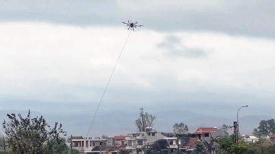
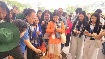
The Vinh Moc tunnel area has been surveyed in the field and important locations have been marked - Photo: PROVIDED BY THE AUTHOR GROUP
We use advanced technologies such as GIS, GPS, UAV and 3D laser scanning techniques to accurately reconstruct the entire large-scale and unique tunnel project so that the relevant agencies have a database to build a suitable restoration and conservation plan. This is also the way for our young generation to show gratitude to those who created this meaningful project in particular and the success of the anti-American resistance war of the entire nation in general.
- Specifically, how did the group of authors implement the research topic, sir?
- To obtain a suitable technical solution, we conducted field surveys at Vinh Moc tunnel many times, using GIS technology, UAV techniques, building 3D models with modern equipment including 3D laser scanners, GPS satellite positioning and navigation devices, handheld multi-parameter distance measuring devices... within the entire protected area of the tunnel of about 55 hectares.
The technologies that the group applies such as GIS, UAV, 3D ground laser scanning techniques and supporting tools have completely replaced traditional tools in managing and preserving cultural heritages. Moreover, data from GIS and 3D can also create VR360 applications with high-resolution Spherical Panorama 360 photos.
- You have successfully carried out a number of research projects on applying technology to digitizing heritage. What about this project?
- Through many research and evaluations and with the support of ANTHI Vietnam Co., Ltd., we have applied 3D laser scanning technology and GIS technology in collecting and building the database of Vinh Moc tunnels and Vinh Linh tunnel village system. The purpose of this work is to propose a feasible technical solution to build a complete database of the entire Vinh Moc tunnel area and Vinh Linh tunnel village system to clearly show the relationship between the ground surface and the deep basements built during the war.
Thereby creating effective derivative products serving education, promoting heritage images, building licensing records, sharing data for scientific and historical researchers... Initially, we have completed the GIS database with maps and non-spatial data such as descriptions, coordinates, images, video clips; created some 3D data (images and videos) including overview data of the tunnel system and surface of the Vinh Moc tunnel area.
Based on GIS and 3D Vinh Moc tunnel database, by using specialized graphic software, we can create many valuable derivative products to serve many different exploitation purposes.
For example, creating complete 3D models integrated into GIS systems to serve the management, preservation, maintenance and restoration of relics over time; creating short films to serve the construction of scientific and technical films, historical films or short films to serve tourism promotion; creating accurate 2D and 3D drawings of the entire tunnel to serve scientists, students and those interested in learning about a very important location in the struggle against the US to save the country.
Building a virtual tourism model to serve the promotion of tourism development, tourism products can be shared directly through a wide promotion channel to the community on the internet; supporting records to serve the archiving and conservation work. In case of unexpected risks to the relic in the future, we still have in hand the entire accurate 3D model of Vinh Moc tunnel.
This is the scientific basis for the process of building a relic profile (including 3D models, detailed drawings, GIS database upon request ...) to propose to relevant agencies in considering, upgrading or granting UNESCO Cultural Heritage certification to the Vinh Moc tunnel historical relic according to UNESCO Criterion IV - is an outstanding example of a type of construction, an architectural complex, technology, or a landscape illustrating one (or more) stages in human history; UNESCO Criterion V - is an outstanding example of a type of traditional human settlement, land use, or sea use, representing one (or more) cultures or interactions between humans and the environment, especially when it has become vulnerable to disruption under the impact of irreversible changes.
In the near future, when conditions permit, it is possible to re-perform the task of scanning and collecting GIS and 3D data for the entire area, comparing it with the 3D model built at this time to have accurate assessments of the level of change and deformation of the tunnel system as well as the surface above. From there, build the most reasonable protection and restoration plans to ensure the longevity of the project over time.
- From the practical research of the topic, what suggestions does the group have, sir?
- It is necessary to support more State funding to continue expanding the survey, assessment and construction of the database of the special national historical site of Vinh Moc tunnels and Vinh Linh tunnel village system including Vinh Moc tunnel system; Hien Dung tunnel system (Vinh Nam commune, now Trung Nam commune); Huong Nam tunnel system, Troong Mon-Cua Hang, Thon Rooc and Navy tunnels (Vinh Kim commune, now Kim Thach commune); Mui Si tunnel system, Tunnel 61 (Cua Tung town) and Navy tunnels (Trung Nam commune). In addition, it is necessary to complete the digital bank of historical relic database of Quang Tri province to have a highly applicable end product such as the Quang Tri Cultural Heritage App.
This will be an extremely important GIS and 3D database serving scientists, domestic and foreign tourists, and a document serving the education and training of the young generation. At the same time, this will also be an effective tool to build the image of Quang Tri province in the future, contributing to promoting the development of smart tourism.
Thank you!
Lam Thanh (performed)
Source: https://baoquangtri.vn/ung-dung-cong-nghe-hien-dai-de-xay-dung-ho-so-di-san-van-hoa-188119.htm


![[Photo] 60th Anniversary of the Founding of the Vietnam Association of Photographic Artists](/_next/image?url=https%3A%2F%2Fvphoto.vietnam.vn%2Fthumb%2F1200x675%2Fvietnam%2Fresource%2FIMAGE%2F2025%2F12%2F05%2F1764935864512_a1-bnd-0841-9740-jpg.webp&w=3840&q=75)


![[Photo] National Assembly Chairman Tran Thanh Man attends the VinFuture 2025 Award Ceremony](/_next/image?url=https%3A%2F%2Fvphoto.vietnam.vn%2Fthumb%2F1200x675%2Fvietnam%2Fresource%2FIMAGE%2F2025%2F12%2F05%2F1764951162416_2628509768338816493-6995-jpg.webp&w=3840&q=75)


![[Photo] Prime Minister Pham Minh Chinh chairs meeting on science, technology development, innovation, digital transformation](https://vphoto.vietnam.vn/thumb/402x226/vietnam/resource/IMAGE/2025/11/15/1763182922583_dsc-0005-jpg.webp)


Comment (0)