
The Shanghai Academy of Aerospace Technology (SAST) under the China Aerospace Science and Technology Corporation (CASC) said that the two mapping satellites Siwei Gaojing-2 (SuperView Neo-2) 03 and 04 were launched by a Long March-2C carrier rocket from the Jiuquan Satellite Launch Center in northwest China at 7:39 a.m. on November 25.
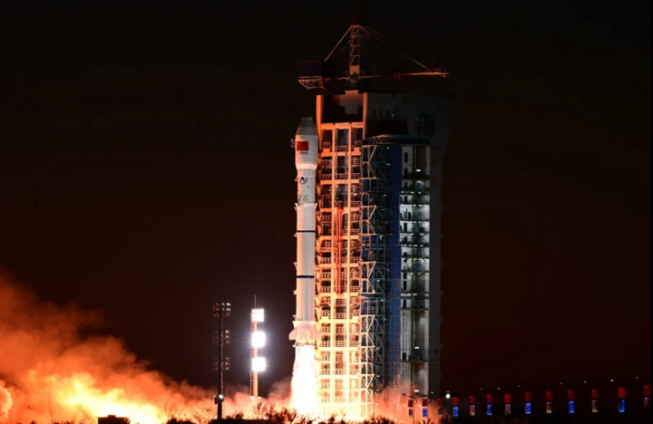
The Long March-2C rocket took off from the Jiuquan Satellite Launch Center, delivering the Siwei Gaojing-2 03 and 04 satellites into their designated orbits. (Photo: Xinhua)
SAST said the launch marked a milestone in the development of China's commercial space surveying and mapping industry. The pair of satellites will usher in a new era of "autonomous" commercial satellites.
"For the first time in the world, the pair of satellites after entering orbit can achieve automatic orbit correction with an error of less than 100 m and coordinated flight in formation with an error of less than 1 m," SAST said in the announcement, adding that this can simplify orbit control and ensure higher safety.
Gaojing-2 03 and 04 are equipped with high-precision radar and other advanced technologies, which can provide high-resolution radar images, operate day and night and in all weather conditions, greatly improving the accuracy of surveying and mapping products.
According to SAST, when operational, the satellites will provide data for natural resource management, urban safety, emergency response and maritime operations.
The organization added that the high-resolution and high-quality radar images sent back by the satellites will support the updating of China's survey and mapping databases, help monitor agricultural production, the environment, and provide early warning of natural disasters.
The two satellites Gaojing-2 03 and 04 are key parts of China's Siwei commercial remote observation constellation project, approved by CASC in April 2022 and expected to be completed next year.
The project includes a network of at least 28 satellites, designed to meet the needs of various industries, such as national land management, mapping and maritime surveillance,... with high-resolution and detailed data.
The commercial optical satellite Siwei Gaojing-3 01, also developed by SAST, was successfully launched in April.
Unlike optical sensor satellites that operate in the visible and near-infrared wavelengths, Gaojing-2 03 and 04 are synthetic aperture radar (SAR) satellites, which use microwave signals to create images by sending pulses of energy down to Earth and measuring how long it takes for them to return.
Low Earth orbit SAR satellites can penetrate clouds, fog and darkness to collect images day and night and are used by some countries to monitor earthquakes, floods, deforestation and oil spills, as well as for military surveillance.
Last August, China launched the world's first geostationary orbit SAR satellite, Ludi Tance 4-01, giving the country permanent observation of nearly one-third of the Earth's surface.
Source: https://vtcnews.vn/trung-quoc-phong-ve-tinh-tu-lai-dau-tien-tren-the-gioi-ar909941.html

![[Photo] Prime Minister Pham Minh Chinh chairs conference on anti-smuggling, trade fraud, and counterfeit goods](https://vphoto.vietnam.vn/thumb/1200x675/vietnam/resource/IMAGE/2025/5/14/6cd67667e99e4248b7d4f587fd21e37c)


![[Photo] Explore the Great Wall of Water in the Suburbs of Beijing, China](https://vphoto.vietnam.vn/thumb/402x226/vietnam/resource/IMAGE/2025/5/5/c2e706533d824a329167c84669e581a0)


Comment (0)