
TPO - Today's weather forecast in Ho Chi Minh City is for scattered showers and thunderstorms, with heavy rain in some places. Be on guard for the possibility of flooding.
The lowest temperature in Ho Chi Minh City today is 25 degrees Celsius, the highest is 32 degrees Celsius; the relative humidity is generally 83%. This evening, showers and thunderstorms are forecast to continue, with heavy rain in some places. Thunderstorms, lightning, and strong gusts of wind may still occur during the rain.
In recent days, Ho Chi Minh City and the southern provinces and cities have experienced widespread heavy rain , causing flooding on many roads. According to the National Center for Hydro-Meteorological Forecasting, last night and early this morning (October 9), there were showers and thunderstorms in the Central Highlands and the South, with some places experiencing heavy to very heavy rain. The rainfall from 7 p.m. on October 8 to 3 a.m. on October 9 was over 70mm in some places, such as Tan Binh ( Tay Ninh ) with 89.2mm,...
Forecast for the day and night of October 9, in the area from Binh Dinh to Binh Thuan , the Southern Central Highlands and the South, there will be scattered showers and thunderstorms, locally heavy rain with rainfall from 15-30mm, locally over 70mm (thunderstorms are concentrated in the afternoon and evening). During thunderstorms, there is a possibility of tornadoes, lightning and strong gusts of wind. Local heavy rain can cause flooding in low-lying areas; flash floods on small rivers and streams, landslides on steep slopes.
 |
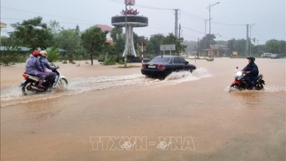
Heavy rain caused flooding on many streets in Ho Chi Minh City on the afternoon of October 8. Photo: Pham Nguyen |
Meanwhile, according to the Southern Hydrometeorological Station, the equatorial low pressure trough with its axis at about 7-10 degrees North latitude combined with high-altitude easterly wind disturbances is affecting and causing rain in the Southern region. Total rainfall in the first 10 days of October is generally from 70 - 170 mm, approximately equal to or higher than the average of many years.
During the 10 days in mid-October (from October 10 to 20), the low pressure trough is likely to become active again. The weather in the area is generally rainy, scattered showers in many places. It is necessary to be on guard against the possibility of widespread rain with some places having moderate, heavy to very heavy rain lasting for a few days. Be on guard against thunderstorms, tornadoes, lightning, and gusts of wind that may appear during thunderstorms. Total rainfall is generally higher than the average of many years in the same period, from 90-160mm.
During the last 11 days of October, the Southern region is mainly affected by the southern edge of the continental cold high pressure tongue and the northern low pressure trough with an axis at about 4-7 degrees north latitude; the wind changes to the northeast with weak to moderate intensity. During this time, the East Sea is likely to have storms or tropical depressions causing widespread rain in the area for a few days. Total rainfall during this time will be higher than the average of many years in the same period, commonly from 70-100mm.
Thus, in the middle and end of October, Ho Chi Minh City and the southern provinces and cities are likely to continue to experience widespread heavy rains. This year's rainy season is likely to end approximately 5-10 days later than the average of many years and generally around mid-December.
It is forecasted that in the first half of November, there will also be 1-2 widespread rains, but these rains will generally be small to moderate in amount, and heavy rain will no longer be common.


Source: https://tienphong.vn/tphcm-tiep-tuc-mua-to-dot-mua-lon-nay-keo-dai-den-bao-gio-post1680503.tpo
![[Photo] Cat Ba - Green island paradise](/_next/image?url=https%3A%2F%2Fvphoto.vietnam.vn%2Fthumb%2F1200x675%2Fvietnam%2Fresource%2FIMAGE%2F2025%2F12%2F04%2F1764821844074_ndo_br_1-dcbthienduongxanh638-jpg.webp&w=3840&q=75)


Comment (0)