
TPO - The Hydrometeorological Agency forecasts that the peak tide in Ho Chi Minh City is likely to appear on September 20 and 21 between 5-7am and 5-7pm.
According to the Southern Hydrometeorological Station, in the past 24 hours, water levels at stations downstream of the Saigon - Dong Nai river system continued to rise rapidly following the high tide of the 15th day of the 8th lunar month and reached approximately Alarm Level II.
It is forecasted that in the next 2-3 days, water levels at stations will continue to rise rapidly. The highest peak tide during this period is likely to appear on September 20 and 21 (ie August 18-19 of the lunar calendar) and reach the following levels:
At Phu An station (Sai Gon river), Nha Be (Dong Dien river) at 1.6 - 1.65m (approximately or 0.05m higher than Alarm III).
Peak tides occur from 5am - 7am and 5pm - 7pm. The disaster risk level in the downstream area of Saigon - Dong Nai River is at level 2.
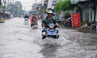
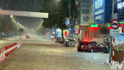
“High peak tide levels are likely to cause flooding in low-lying areas and riverside areas, affecting traffic, daily life, and socio -economic activities in the Ho Chi Minh City area.
Some roads in Ho Chi Minh City may be flooded, such as Tran Xuan Soan, Dao Su Tich, Huynh Tan Phat, Nguyen Binh, Le Van Luong, National Highway 50, Pham Huu Lau (concentrated in District 7 and Nha Be District)," the Southern Regional Hydrometeorological Station informed.
In addition, in the past 24 hours, water levels at most stations in the downstream areas of the rivers in the Southwest region rose rapidly and at high levels. At 7:00 a.m. on September 19, the highest water level measured at Can Tho station (Hau River) was 1.93m (approximately 0.03m above Alarm Level II), and at My Thuan station (Tien River) was 1.91m (0.11m above Alarm Level III).
The highest water level of the day at most stations on rivers, canals and streams in the Southwest region is forecast to continue to rise rapidly following the high tide of the 15th day of the 8th lunar month in the next 3-4 days. The highest peak tide of this period is likely to appear on September 20-21 (August 18-19 of the lunar calendar) and at the following levels:
My Thuan station can reach about 1.95 - 2.00m, 0.15 - 0.20m higher than Alarm III. Can Tho station can reach about 2.00 - 2.05m at a level approximately equal to or 0.05m higher than Alarm III;
Coastal estuary stations may fluctuate at Alarm Level I to Alarm Level II, with Ganh Hao station alone likely to reach approximately Alarm Level III.
The Southern Hydrometeorological Station said the disaster risk level in the lower reaches of the Tien and Hau rivers is level 2. This is a high tide, which can cause flooding in low-lying areas and riverside areas, affecting socio-economic activities in the area.


Source: https://tienphong.vn/tphcm-don-dinh-trieu-cuong-nhung-khu-vuc-nao-co-nguy-co-ngap-post1674596.tpo

![[Photo] Urgently help people soon have a place to live and stabilize their lives](/_next/image?url=https%3A%2F%2Fvphoto.vietnam.vn%2Fthumb%2F1200x675%2Fvietnam%2Fresource%2FIMAGE%2F2025%2F12%2F09%2F1765248230297_c-jpg.webp&w=3840&q=75)


![[Photo] General Secretary To Lam works with the Standing Committees of the 14th Party Congress Subcommittees](https://vphoto.vietnam.vn/thumb/402x226/vietnam/resource/IMAGE/2025/12/09/1765265023554_image.jpeg)


Comment (0)