
According to the 10-day weather forecast for Ho Chi Minh City (August 12-22) by the Southern Hydrometeorological Station, the low pressure trough with its axis passing through the North is still in place. The southwest monsoon maintains its average intensity over the southern seas.
Above, the subtropical high pressure weakens, from around August 13-14 it is likely to strengthen and encroach on the West again and slowly lift its axis to the North.
From August 14-18, there will be a wind convergence zone at 500mb in the Southern region.
Therefore, this meteorological agency predicts that in Ho Chi Minh City in the next 10 days, the rainy and thunderstorm weather situation will tend to increase again.
At the same time, the National Center for Hydro-Meteorological Forecasting also assessed that from August 11 to September 10, the Southwest monsoon in the South is likely to continue to cause many days of showers and thunderstorms in the Central Highlands and the South, with some days of strong thunderstorms and heavy rain, concentrated in the late afternoon.
Specifically, this afternoon and evening (August 12), this area will have scattered showers and thunderstorms in some places; from this afternoon and tomorrow evening, there will be continuous scattered showers and thunderstorms, locally with moderate to heavy rain.
The meteorological agency said that in the next month, total rainfall in the Central Highlands and the South will be 5-15% higher than the average of many years in the same period.
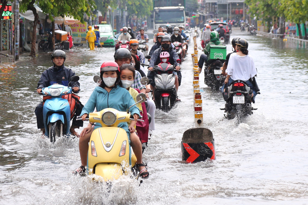
During thunderstorms, be on guard against the possibility of extreme weather events such as thunder, lightning, tornadoes, and strong gusts of wind that can be dangerous for people driving and working outdoors. Be on guard against heavy rain causing localized flooding in low-lying areas, riverbanks, and urban areas.
In addition, in the next 1 month, the tropical convergence zone will continue to operate and is likely to form a tropical depression/storm in the East Sea. The tropical convergence zone will cause the southwest monsoon to be active in the southern seas, so it is necessary to be cautious of strong winds and large waves affecting maritime activities and fishing of fishermen.
Previously, the National Center for Hydro-Meteorological Forecasting assessed that provinces and cities in the Central Highlands, the South and the South Central regions experienced a month (July 2023) of unusually heavy rain.
Accordingly, due to the influence of the southwest monsoon, there were widespread thunderstorms in many days of the month. In particular, in the second half of the month, the whole region had continuous moderate rain, heavy rain, and in some places very heavy rain.
Total rainfall in July in this area was 50-100% higher than the average of many years, in some places over 100%. Notably, some places observed daily rainfall values and total monthly rainfall exceeding historical values compared to the same period in July.

Northern and Central regions will have heavy rain in the next month.
During the period from August 11 to September 10, total rainfall in most places across the country will be 5-15% higher, especially in the North and Central Central regions, from 15-25% higher than the average for the same period. There is a possibility of 1-2 storms and tropical depressions in the East Sea.
Source
![[Photo] National Assembly Chairman Tran Thanh Man meets with Thai Prime Minister Paetongtarn Shinawatra](https://vphoto.vietnam.vn/thumb/1200x675/vietnam/resource/IMAGE/2025/5/15/e71160b1572a457395f2816d84a18b45)


![[Photo] Prime Ministers of Vietnam and Thailand visit the Exhibition of traditional handicraft products](https://vphoto.vietnam.vn/thumb/1200x675/vietnam/resource/IMAGE/2025/5/15/6cfcd1c23b3e4a238b7fcf93c91a65dd)


Comment (0)