
Storm Tra Mi, with gusts of level 11, is moving rapidly and will continue to strengthen and enter the East Sea. Currently, in the northeastern sea area of the North East Sea, there are strong winds of level 6 - 7.
According to the National Center for Hydro-Meteorological Forecasting, storm Tra Mi is active near the East Sea.
At 1:00 a.m. on October 23, the center of storm Tra Mi was at about 15.2 degrees North latitude; 125.4 degrees East longitude, in the sea east of the central Philippines. The strongest wind near the center of the storm was level 9 (75-88 km/h), gusting to level 11. Moving northwest at a speed of about 20 km/h.
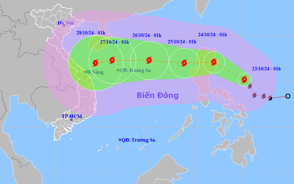
In the following hours, the storm will mainly move in the Northwest direction, at a speed of about 15km/h. At about 1am on October 24, the center of storm Tra Mi was at about 17.1 degrees North latitude; 122.1 degrees East longitude, on the mainland east of Lu Giong Island (Philippines); storm intensity level 10, gust level 12.
In particular, the meteorological agency predicts that this storm will continue to strengthen and enter the East Sea.
| Forecast time | Direction, speed | Location | Intensity | Danger zone | Disaster Risk Level (Affected Area) |
|---|---|---|---|---|---|
| 1h/24/10 | Northwest, about 15km/h | 17.1N-122.1E; on the mainland east of Luzon Island (Philippines) | Level 10, level 12 | Latitude 14N-19N; East of longitude 120E | |
| 1h/25/10 | West, about 15km/h, entering the East Sea | 17N-118.9E; in the eastern sea area of the North East Sea | Level 10, level 12 | Latitude 15N-19N; East of longitude 117E | Level 3: East of the North East Sea area |
| 1h/26/10 | West Northwest, about 15km/h | 17.3N-115.1E; 330km East Northeast of Hoang Sa archipelago | Level 11, level 14 | Latitude 15N-20N; East of longitude 113E | Level 3: North East Sea area |
Weather on the East Sea
Currently, in the northeastern sea area of the North East Sea, there are strong northeast winds of level 6, sometimes level 7.
The Central and Southern East Sea (including the Truong Sa archipelago) and the sea from Phu Yen to Ca Mau have scattered showers and thunderstorms.
Forecast for the next 24 hours:
| Forecast time | Affected sea areas | Strong winds | Wave height | ||
|---|---|---|---|---|---|
| Day and night October 23 | Wind level (Bophorus level) | Direction | Height (meters) | Direction | |
| Eastern sea area of the North East Sea | Level 6 - 7, gust level 8 - 9. Rough sea. | Northeast | 4 - 6 | Northeast | |
| Gulf of Tonkin, the western sea area of the North East Sea (including the sea area of the Paracel Islands) | Level 6, sometimes level 7, gusting to level 8-9. Rough sea. Wind gradually decreases at night. | Northeast | 3 - 5; for the Gulf of Tonkin 2 - 3.5 | Northeast | |
| Sea area from Quang Tri to Binh Thuan and the Central East Sea area | Level 5, sometimes level 6, gusts level 7 - 8. Rough sea. | Northeast | 2 - 3.5; in the Central East Sea area, waves are 3 - 5 meters high. | Northeast | |
| The eastern sea of the South China Sea region | Level 5, sometimes level 6, gusts level 7 - 8. Rough sea. | Southwest | 2 - 3 | Southwest | |
In addition, today and tonight, the Central and Southern East Sea (including the Truong Sa archipelago), the area from Binh Dinh to Ca Mau, Ca Mau to Kien Giang and the Gulf of Thailand will have scattered showers and thunderstorms; from the afternoon of October 23, the Eastern sea of the Northern East Sea will have showers and thunderstorms. During thunderstorms, there is a possibility of tornadoes and strong gusts of wind of level 7-8.
Warning day and night 24/10, due to the influence of storm Tra Mi, the North East Sea area (including the sea area of Hoang Sa archipelago) has strong Northeast wind level 6-7, gust level 8-9; in the Eastern sea area it increases to level 8-9, near the storm center level 10-11, gust level 14; waves 4-6m high, near the storm center 6-8m; rough sea.
The eastern sea area of the Central East Sea has strong northwest to west winds at level 6-7, gusting to level 8-9; rough seas; waves 3-5m high.
The sea area from Quang Tri to Khanh Hoa has strong North to Northwest wind level 6, gusting to level 7-8; rough sea; waves from 2 - 4.5m high.
All vessels operating in the above areas are at high risk of being affected by cyclones, strong winds and large waves.
Source: https://vietnamnet.vn/tin-bao-tra-mi-moi-nhat-ngay-23-10-va-thoi-tiet-bien-dong-2334554.html


Comment (0)