
According to the latest storm information from the National Center for Hydro-Meteorological Forecasting, at 3:00 a.m. on October 27, the center of storm No. 6 (storm Tra Mi) was located at about 16.9 degrees North latitude; 109.1 degrees East longitude, about 133km East Northeast of Da Nang. The strongest wind is level 9 - 10 (89-102km/h), gusting to level 13.
Forecast in the next 3 hours, the storm moves in the West Southwest direction, speed about 15-20km/h.
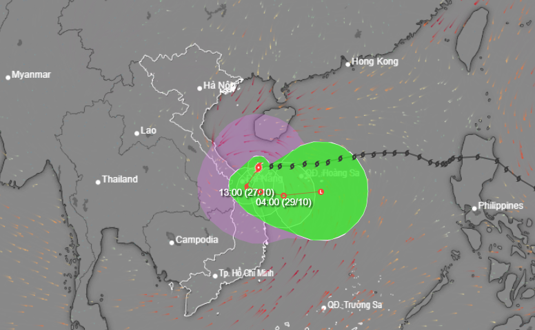
Today (October 27), storm No. 6 entered the Quang Tri - Quang Nam provinces, then moved back out to sea and gradually weakened. From Quang Binh to Quang Ngai, heavy rain, locally over 700mm.
Currently, Bach Long Vi island area has strong winds of level 6-7, sometimes level 8, gusting to level 9; Con Co island, Ly Son has strong gusts of level 7.
In the western sea area of the North East Sea, there will be storms; in the southern Gulf of Tonkin and the sea area from Quang Tri to Quang Ngai, there will be showers and strong thunderstorms.
Forecast impact of storm number 6:
The western sea area of the North East Sea has strong winds of level 7-8, near the storm center, level 9-10 (75-102km/h), gusts of level 12, waves 3-4.5m high, near the storm center, 4.5-6.0m; very rough seas.
The sea area of provinces from Quang Binh to Quang Ngai (including Con Co Island, Cu Lao Cham, Ly Son) has strong winds of level 6-7, then increasing to level 8, near the storm's eye level 9-10, gusting to level 12, waves 2-4m high, near the storm's eye 3-5m; very rough seas.
Storm surge in coastal areas: from the morning of October 27, coastal areas from Quang Binh to Quang Nam provinces are likely to experience storm surges of 0.4-0.6m high.
Ships operating in the above-mentioned dangerous areas (especially in the Hoang Sa island district), coastal areas from Quang Binh to Quang Ngai are likely to be affected by storms, whirlwinds, strong winds, and big waves.
High risk of landslides of sea dikes and embankments along the coast of provinces from Quang Tri to Quang Nam due to the impact of big waves and storm surges.
On land, from the morning of October 27, on land from Quang Binh to Quang Ngai, winds will gradually increase to level 6-7, gusting to level 8-9; near the storm center, level 8, gusting to level 11.
From early morning of October 27 to night of October 28, in the area from Quang Binh to Quang Ngai, there will be heavy to very heavy rain with total rainfall ranging from 200-400mm, locally over 600mm. Warning of risk of localized heavy rain (>100mm/3h).
Ha Tinh, Binh Dinh and the Northern Central Highlands have heavy rain, locally very heavy rain with total rainfall ranging from 100-180mm, in some places over 250mm.
Storm Kong-rey strengthens
Tropical Storm Kong-rey is moving westward over the weekend, turning west-northwest on Monday (October 28) and northwest-northwest for the remainder of the forecast period, the Philippine Atmospheric, Geophysical and Astronomical Services Administration (PAGASA) said.
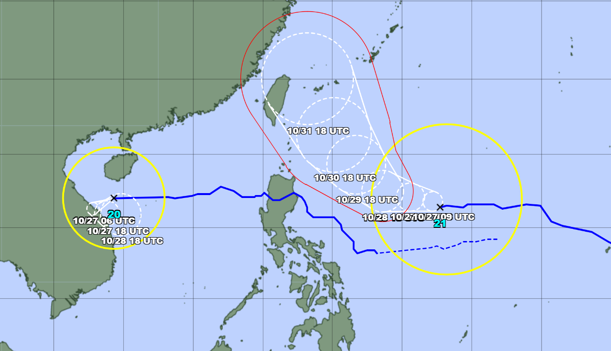
According to PAGASA, Typhoon Kong-rey is forecast to gradually strengthen and may reach severe tropical storm level on October 27 and typhoon level on October 28. Typhoon Kong-rey may hit Luzon Island (Philippines), approaching the East Sea.

![[Photo] Prime Minister Pham Minh Chinh works with the Standing Committee of Thai Binh Provincial Party Committee](https://vphoto.vietnam.vn/thumb/1200x675/vietnam/resource/IMAGE/2025/5/12/f514ab990c544e05a446f77bba59c7d1)
![[Photo] Prime Minister Pham Minh Chinh starts construction of vital highway through Thai Binh and Nam Dinh](https://vphoto.vietnam.vn/thumb/1200x675/vietnam/resource/IMAGE/2025/5/12/52d98584ccea4c8dbf7c7f7484433af5)
![[Photo] Prime Minister Pham Minh Chinh receives Swedish Minister of International Development Cooperation and Foreign Trade](https://vphoto.vietnam.vn/thumb/1200x675/vietnam/resource/IMAGE/2025/5/12/ae50d0bb57584fd1bbe1cd77d9ad6d97)


Comment (0)