
With the forecast that storm No. 6 (storm Tra Mi) will cause heavy rain and a high risk of landslides in many localities, Thua Thien Hue province requires proactively organizing the evacuation of people in areas at risk of flash floods, landslides, deep flooding, and areas that are easily isolated.
According to the Hydrometeorological Station of Thua Thien Hue province, due to the influence of storm No. 6 (storm Tra Mi), from the night of October 26 to October 29, the province will have rain, moderate rain, scattered heavy rain, some places very heavy rain and thunderstorms. The total rainfall for the period is commonly 200-400mm, some places over 500mm, the rain with the highest intensity concentrated on October 27-28.

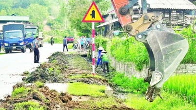
The scene of a horrific landslide at Rao Trang 3 Hydropower Plant (Phong Xuan Commune, Phong Dien District, Thua Thien Hue) in October 2020. Currently, the mountainous area of Phong Xuan Commune is warned to be at very high risk of landslides. Photo: Contributor.
Heavy rains are likely to cause flash floods, landslides, and rock slides in mountainous areas and along small rivers and streams in A Luoi, Nam Dong, Phong Dien, Phu Loc districts, Huong Tra town..., and also cause urban flooding and areas with poor drainage systems in some districts, towns and Hue city.
On October 25, the Chairman of the People's Committee of Thua Thien Hue province sent an urgent telegram to the People's Committees of districts, towns, cities and departments and branches in the province to deploy measures to respond to storm No. 6.
On the same day, the Steering Committee for Natural Disaster Prevention and Search and Rescue of Thua Thien Hue province continued to update warnings about locations at risk of flash floods, landslides in mountainous areas and traffic routes, riverbank and coastal landslides in the province.
Accordingly, as of October 25, most districts, towns and cities in Thua Thien Hue province have areas at risk of landslides in mountainous areas, steep slopes of traffic routes; landslides, riverbank and coastal erosion, when rain and storms occur.
Specifically, in Phong Dien district, there is a very high risk of landslides in mountainous areas in the communes of Phong Xuan, Phong My, Phong Son, Phong An, Phong Thu, Phong Dien town... and landslides on traffic routes of Highway 71 from Phong Xuan to Rao Trang 3 hydropower plant, Rao Trang 4, A Lin B2, A Lin B1...
In Quang Dien district, there is a very high risk of landslides occurring on the Bo River through the communes of Quang Phu, Quang Tho, Quang Phuoc, Quang Thanh, and Quang An. In Huong Tra town, there is a risk of landslides in the Binh Tien hill area (the landslide point is in Dong Hoa village), Huong Binh, Binh Thanh (the landslide point is in Tan Tho village), Huong Van and Huong Van wards.
In A Luoi district, the risk of landslides on traffic routes is very high along the Ho Chi Minh Highway through Tru Pi village (Hong Thuy commune), the People's Committee of Quang Nham commune (formerly Hong Quang commune) and the communes of Lam Dot, A Roang, Huong Nguyen. Along National Highway 49A through the communes of Phu Vinh (A Co pass), Huong Nguyen, Hong Ha of A Luoi district, there is also a very high risk of landslides...

Heavy rains caused by storm Tra Mi are likely to cause flash floods, landslides, rock slides, and urban flooding and areas with poor drainage systems in Thua Thien Hue province. Photo: TH
In Nam Dong district, there is a very high risk of flash floods and landslides in Doi village, village 1, village 2 of Huong Loc commune; landslides on hills, riverbanks, flash floods in Lap village, A Tin village, Thuong Nhat commune.
In Phu Loc district, there is a high risk of coastal erosion in the section through Giang Hai and Vinh My communes, especially adjacent to the two ends of Giang Hai embankment; there is a risk of coastal erosion in the section through Vinh Hien, Vinh My, Loc Vinh communes...
The Steering Committee for Natural Disaster Prevention and Search and Rescue of Thua Thien Hue province requested localities and units to proactively organize the relocation and evacuation of people in areas at risk of flash floods, landslides, deep flooding, and areas that are easily isolated.
Dam owners, exploitation management units, investors in hydroelectric and irrigation works are assigned to continue to inspect, promptly detect and handle points at risk of landslides along the lakeshore and upstream and downstream of key works.
By October 25, all 1,884 fishing boats of Thua Thien Hue fishermen with 10,685 workers had come ashore to avoid storm Tra Mi. In addition, 20 cargo ships with 166 crew members had also safely anchored at seaports in Thua Thien Hue.
Source: https://danviet.vn/thua-thien-hue-canh-bao-bao-tra-mi-gay-mua-lon-nhieu-khu-vuc-co-nguy-co-sat-lo-cao-20241025172833418.htm


![[Photo] Readers line up to visit the photo exhibition and receive a special publication commemorating the 135th birthday of President Ho Chi Minh at Nhan Dan Newspaper](https://vphoto.vietnam.vn/thumb/1200x675/vietnam/resource/IMAGE/2025/5/17/85b3197fc6bd43e6a9ee4db15101005b)

![[Photo] Nearly 3,000 students moved by stories about soldiers](https://vphoto.vietnam.vn/thumb/1200x675/vietnam/resource/IMAGE/2025/5/17/21da57c8241e42438b423eaa37215e0e)


Comment (0)