
This is believed to stem from the fact that Google Maps' actual location information is still not displayed accurately even with highly accurate GPS. To explain the inaccuracy of Google Maps, the science news site Nautilus has come up with an explanation.

Google Maps is a popular mapping service used worldwide.
Ken Hudnut, a science adviser to the US Geological Survey, said the discrepancies in Google Maps are not just due to GPS accuracy, but also to geostatistics, which link a map's coordinate system to a geographic coordinate system. For example, a 2008 study examining Google Earth imagery for 31 cities in the developed world found errors ranging from 1 to 50 meters, likely due to drift in georeferencing over time rather than the accuracy of GPS units.
"We're in an age where people want centimeter-level accuracy on their smartphones, but the accuracy of maps and GPS is inconsistent and many people are going to be disappointed," said Drew Smith, an expert at the US National Geodetic Survey (NGS).
The map was made based on surveys. Although the ground where the survey was conducted appears to be stationary, it is in fact constantly moving at an invisible level. According to the theory of plate tectonics proposed in the late 1960s, the Earth's surface is covered by a crust called "tectonic plates", up to 100 km thick, and these tectonic plates are constantly moving.
NGS has established a reference coordinate system called “NAD83” to survey the North American continent. NAD83 is an important coordinate system for surveyors in North America because it matches the movements of the North American tectonic plate. On the other hand, GPS uses “WGS84”, a reference coordinate system for the entire Earth.
It is known that there is an error of several meters between NAD83 and WGS84, and the deviation is increasing. NAD83 does not reflect the knowledge of the shape and size of the Earth, and the coordinates of the center of the Earth are about 2 meters different from WGS84. NGS updated NAD83 in 2022, but it still has a deviation of about 1 meter.
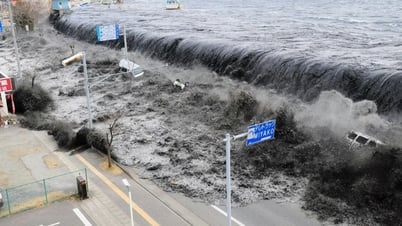
During the Great East Japan Earthquake of 2011, GPS recorded tectonic plate movement in real time, with the coastline near the epicenter shifting horizontally by up to 4 meters. When such a large earthquake occurs, the Earth's surface can shift significantly along the fault line, sometimes by several meters.
It takes time for these changes to be reflected on the map, so the difference between GPS location information and the map becomes wider and wider. So Google Maps can only show circles to more or less show the accuracy, which can be a few meters off.
Source link


Comment (0)