
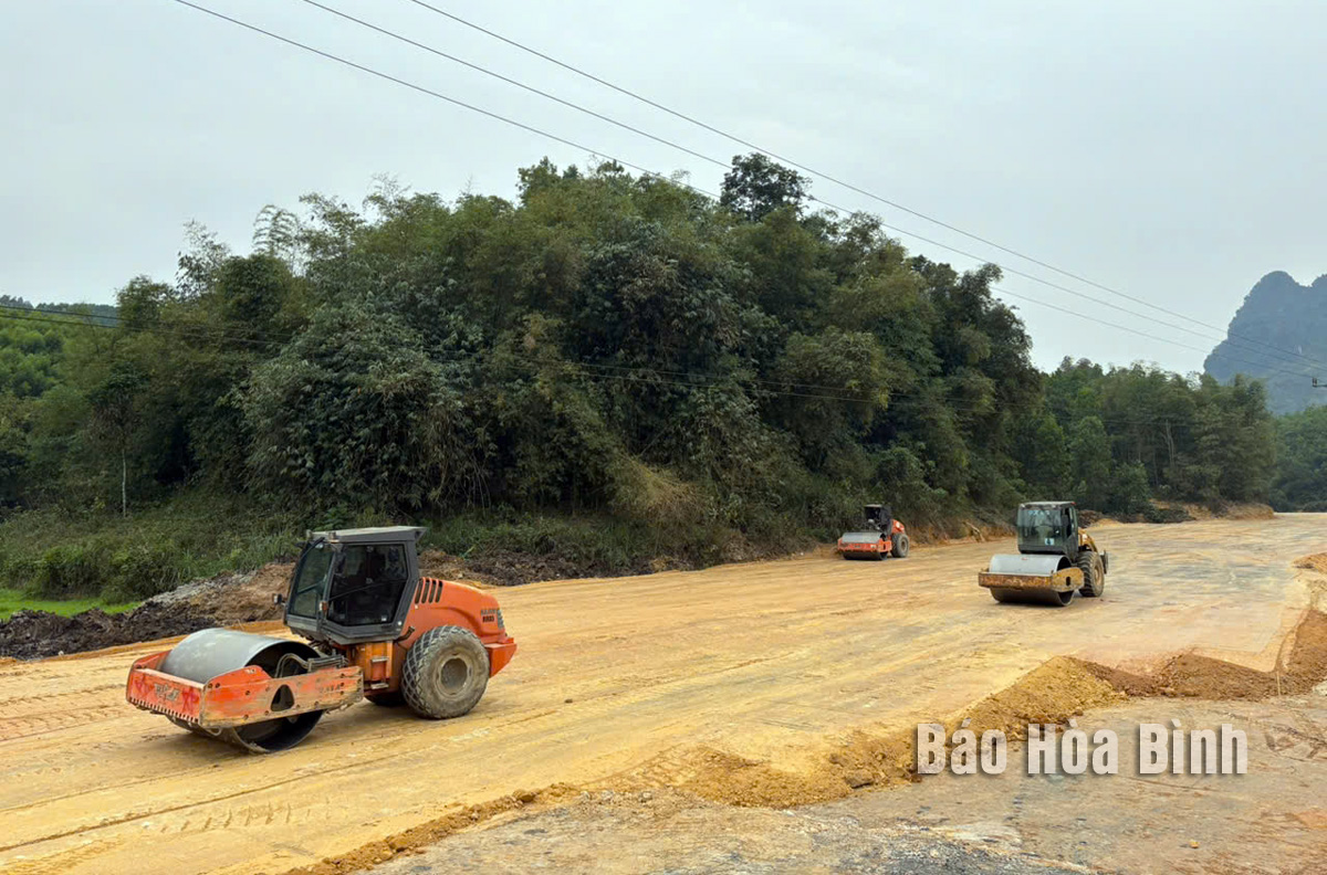
The construction unit is leveling the ground of the regional connecting road through Du Sang commune, Kim Boi district.
Up to this point, localities have handed over to the construction unit 23.79km/32km of the entire route, reaching about 74%. Of which, Kim Boi district handed over 12.69/16.3km; Luong Son district handed over 6.1km/7.9km; Hoa Binh city handed over 5/7.26km. However, according to the assessment, the handed over locations are still interspersed, making it difficult to access the construction site.
With 16km of the route running through the area, the total land area of Kim Boi district that must be cleared for the regional linking road project is 81.34 hectares. By March 31, 2025, the district had cleared and handed over to the construction unit 69.44 hectares, equivalent to 12.69km of the route. From now until the end of April, the district must clear 11.9 hectares, equivalent to a route length of 3.62km. According to the progress report of the Kim Boi District People's Committee, the land area that needs to be cleared is mainly residential land, agricultural land in the same residential plot and forest land in the communes. Specifically, there are currently 397 plots of land under the project that have not completed the procedures for determining the origin of land use and plots of land to serve as the basis for compensation for households and individuals.
Comrade Bach Cong Ban, Director of the Kim Boi District Land Fund Development Center, said: Verifying the origin of land is under the authority of the People's Committees of communes. For cases that have not been granted a land use right certificate, it is necessary to make a first registration declaration. For cases that have been granted a certificate, the increase or decrease in area must be registered for land changes. However, it is currently quite difficult due to many land changes. Meanwhile, the storage of cadastral records is not synchronized; land use right transfer activities are not in accordance with regulations, not declared... To speed up the progress of verifying the origin of land, the District Land Fund Development Center has sent staff directly to the communes to support the procedures and processes for the communes in the process of verifying the origin of land. Up to this point, the communes have completed 122 plots (79 plots of land change registration; 43 plots of initial registration) and continue to urgently verify the land origin for 275 plots (135 plots of land change registration; 140 plots of initial registration).
In Luong Son district, the work of compensation and support for site clearance for the regional connecting road project is being directed strongly by the Party committees and authorities at all levels. Up to now, the district has cleared 27.29ha/41.21ha of land to be recovered, with 13.92ha still to be cleared. However, the work of compensation and site clearance still has many obstacles due to overlapping forest land locations, incorrect location allocation, and differences in actual land area compared to the land use right certificate... According to comrade Nguyen Anh Duc, Vice Chairman of the People's Committee of Luong Son district, in the 13.92ha of land to be recovered, there are 6.32ha of dumping area; 0.58ha of land has not been granted a land use right certificate; 4ha of forest land is overlapping, incorrectly allocated land use location; 0.4ha belongs to Tuong Anh Brick Factory; 1.29ha of land has differences between the actual land area and the land use right certificate. To implement the land acquisition and clearance work, the District People's Committee has coordinated with the Provincial Traffic Construction Investment Project Management Board to measure and determine the land use rights for 6.32 hectares of landfill land. Up to now, the District Land Fund Development Center has declared and re-inventoried households using the landfill land and the Cao Son Commune People's Committee is verifying the land origin to publicize the compensation and support plan according to regulations. For the overlapping land area, the District People's Committee has directed the Department of Agriculture and Environment to coordinate in inspecting and determining the overlapping location and guiding households to complete the procedures for issuing new land use right certificates according to regulations. After having the results, the district will publicize the compensation and support plan according to the current land use status of the households. Particularly for the land area with differences, the district has coordinated with the measurement consulting unit to adjust the land acquisition and measurement map. In addition, the district continues to strengthen propaganda and mobilization work for households with land areas that have publicly implemented compensation and support plans.
In order to urgently implement the land acquisition and clearance work, the Hoa Binh City Land Fund Development Center is also coordinating with the locality and related units to review, synthesize, develop a compensation and support plan and publicly implement the compensation plan. According to the direction of the City People's Committee, the compensation and clearance work at this stage is identified as an urgent task. The Hoa Binh City People's Committee will develop a plan to enforce against households that intentionally do not cooperate in implementing the compensation and clearance work.
Along with urgently implementing site clearance work, the Provincial Traffic Construction Investment Project Management Board urgently coordinated with localities to arrange dumping sites for the project; plan offline earthworks and relocate technical infrastructure, creating the most favorable conditions for the construction unit to implement the project.
Phuong Linh
Source: https://baohoabinh.com.vn/12/200008/Quyet-tam-hoan-thanh-giai-phong-mat-bang-du-an-duong-lien-ket-vung-truoc-ngay-3042025.htm
![[Photo] Readers line up to visit the photo exhibition and receive a special publication commemorating the 135th birthday of President Ho Chi Minh at Nhan Dan Newspaper](https://vphoto.vietnam.vn/thumb/1200x675/vietnam/resource/IMAGE/2025/5/17/85b3197fc6bd43e6a9ee4db15101005b)


![[Photo] Prime Minister Pham Minh Chinh chairs meeting on science and technology development](https://vphoto.vietnam.vn/thumb/1200x675/vietnam/resource/IMAGE/2025/5/17/ae80dd74c384439789b12013c738a045)
![[Photo] More than 17,000 candidates participate in the 2025 SPT Competency Assessment Test of Hanoi National University of Education](https://vphoto.vietnam.vn/thumb/1200x675/vietnam/resource/IMAGE/2025/5/17/e538d9a1636c407cbb211b314e6303fd)


![[Photo] Nearly 3,000 students moved by stories about soldiers](https://vphoto.vietnam.vn/thumb/1200x675/vietnam/resource/IMAGE/2025/5/17/21da57c8241e42438b423eaa37215e0e)


Comment (0)