
Thanh Xuan District after the arrangement is expected to have the following wards: Thanh Xuan, Khuong Dinh, Phuong Liet.
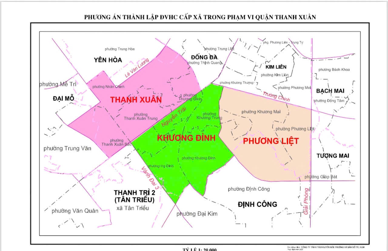
In which, Thanh Xuan administrative unit has a natural area of 3.31km2 , population of 99,491 people. The administrative boundary covers most of the natural area and population of the wards: Thanh Xuan Trung, Thuong Dinh, Nhan Chinh, Thanh Xuan Bac (Thanh Xuan); part of the natural area and population of the wards: Trung Van (Nam Tu Liem), Trung Hoa (Cau Giay).
Administrative unit boundary: East side borders Dong Da, Khuong Dinh administrative unit (boundary follows Nguyen Trai street - To Lich river); West side borders Dai Mo administrative unit (boundary follows Luong The Vinh street - To Huu street - Khuat Duy Tien street); South side borders Khuong Dinh, Tan Trieu administrative unit (boundary follows Nguyen Trai street); North side borders Yen Hoa administrative unit (boundary follows Hoang Ngan street - Hoang Minh Giam street - Le Van Luong street).
Khuong Dinh administrative unit , natural area 3.12km2 , population 93,780 people. Administrative boundaries include most of the natural area and population of the wards: Khuong Dinh, Ha Dinh, Khuong Trung (Thanh Xuan); part of the natural area and population of the wards: Thuong Dinh, Thanh Xuan Trung (Thanh Xuan); Dai Kim (Hoang Mai); Tan Trieu commune (Thanh Tri).
Administrative unit boundary: The East borders the administrative units of Phuong Liet and Dinh Cong (the boundary follows the planned traffic route and the current ward boundary); the West borders the administrative units of Tan Trieu and Thanh Xuan (the boundary follows Nguyen Trai Street - Nguyen Xien Street); the South borders the administrative units of Tan Trieu and Dinh Cong (the boundary follows Nguyen Xien Street); the North borders the administrative units of Dong Da and Kim Lien (the boundary follows Nguyen Trai Street - Truong Chinh Street - Vuong Thua Vu Street).
Phuong Liet grassroots administrative unit has a natural area of 3.24 km2 , population of 97,387 people. Administrative boundaries include the entire area and population of Khuong Mai ward (Thanh Xuan); most of the natural area and population of Phuong Liet ward (Thanh Xuan); part of the natural area and population of the wards: Khuong Trung, Khuong Dinh (Thanh Xuan); Thinh Liet, Giap Bat, Dinh Cong (Hoang Mai).
Administrative unit boundary: East side borders Tuong Mai administrative unit (boundary follows Giai Phong street); West side borders Khuong Dinh administrative unit (boundary follows the planned road along Dam Hong lake - Vuong Thua Vu street); South side borders Dinh Cong administrative unit (boundary follows Ring Road 2.5); North side borders Kim Lien facility (boundary follows Truong Chinh street).
Source: https://hanoimoi.vn/quy-mo-dan-so-dien-tich-3-phuong-du-kien-sau-sap-xep-cua-quan-thanh-xuan-699623.html
![[Photo] General Secretary To Lam concludes visit to Russia, departs for Belarus](https://vphoto.vietnam.vn/thumb/1200x675/vietnam/resource/IMAGE/2025/5/11/0acf1081a95e4b1d9886c67fdafd95ed)


![[Photo] General Secretary To Lam meets and expresses gratitude to Vietnam's Belarusian friends](https://vphoto.vietnam.vn/thumb/1200x675/vietnam/resource/IMAGE/2025/5/11/c515ee2054c54a87aa8a7cb520f2fa6e)
![[Photo] General Secretary To Lam arrives in Minsk, begins state visit to Belarus](https://vphoto.vietnam.vn/thumb/1200x675/vietnam/resource/IMAGE/2025/5/11/76602f587468437f8b5b7104495f444d)


![[Photo] National Assembly Chairman Tran Thanh Man attends the Party Congress of the Committee for Culture and Social Affairs](https://vphoto.vietnam.vn/thumb/1200x675/vietnam/resource/IMAGE/2025/5/11/f5ed02beb9404bca998a08b34ef255a6)


Comment (0)