In just a short period of about 20 days (from the end of March to April 11), in Hiep Luc village (Kim Lu commune, Na Ri district, Bac Kan province), 5 complex subsidence holes appeared consecutively, causing many local residents to worry and feel insecure.
The People's Committee of Na Ri district has made a plan to evacuate more than 20 households here if an emergency situation occurs, and at the same time requested the People's Committee of Bac Kan province to direct specialized agencies and units to urgently inspect and verify the cause, and have solutions to completely handle the subsidence holes...
Mr. Trieu Van Ninh, whose house is near the large sinkhole at Km80+050 National Highway 3B (Hiep Luc village), said that his house was completed in August 2024. After the large sinkhole appeared, his house had many cracks, and was likely affected by the sinkhole. Worried about the worst happening, many nights he and his son did not dare to sleep at home but had to go to his grandfather's house to sleep.
Mr. Ninh hopes that authorities at all levels will soon find the cause and take measures to completely handle the sinkholes.
Mr. Dam Van Quyen (Hiep Luc village) said that after a large sinkhole appeared at Km80+050 of National Highway 3B, his well and his neighbor's well no longer had water.
Mr. Quyen said that this phenomenon is due to the impact of a sinkhole.
By mid-April, through the report and proposal of the People's Committee of Na Ri district, the People's Committee of Bac Kan province directed the Department of Agriculture and Environment to preside over and coordinate with relevant agencies and units to organize inspections, determine the subsidence situation and guide and support Na Ri district to have solutions to ensure safety and stabilize people's lives and production.
On April 16, a working delegation from Bac Kan province, including representatives from the Department of Agriculture and Environment, the Institute of Geosciences and Mineral Resources (Ministry of Agriculture and Environment), the Department of Construction, the People's Committee of Na Ri district, and the People's Committee of Kim Lu commune, conducted a field inspection of the land subsidence phenomenon in the above-mentioned Kim Lu commune.
Participating in the working group to survey 5 subsidence locations and the current status of groundwater exploitation in Hiep Luc village (Kim Lu commune), the Institute of Geological Sciences and Mineral Resources initially determined that this area is distributed with terrigenous sedimentary rocks interspersed with limestone.
All sinkhole locations have an upper layer consisting of weathering products from the original rock consisting of sand, sandy loam, and clay loam, in a loose, weakly bonded state, with a thickness of about 3-5m; followed by gray and gray-white limestone formations, in a weathered, strongly cracked state, with many karst caves containing water.
According to the Institute of Geosciences and Mineral Resources, subsidence in areas characterized by limestone or dolomite (carbonate-based rocks) is a common problem.
The mechanism is as follows: Rainwater containing CO2 will become weak acid (H2CO3), this acid will slowly dissolve limestone (CaCO3), initially from small cracks it will develop into underground caves (karst caves).
Over time, these cavities form large underground voids. When groundwater is exploited too much, the water pressure holding the cavities is reduced, causing mechanical imbalance, causing the cave ceiling to collapse, leading to subsidence and the appearance of sinkholes on the ground as noted.
Furthermore, at locations such as roads with large and frequent dynamic loads (heavy-duty vehicles), or construction sites with large construction loads, the risk of subsidence is even higher.
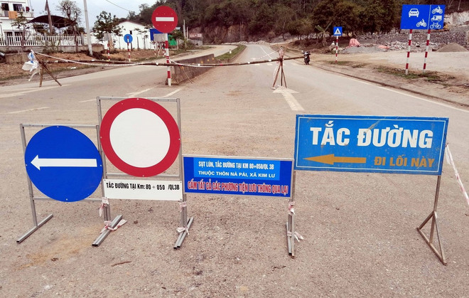
Regarding temporary solutions, the Institute of Geosciences and Mineral Resources recommends zoning off dangerous areas and placing warning signs such as: erecting fences and signs around sinkholes and high-risk areas with signs of subsidence; temporarily evacuating people and nearby structures if there are signs of abnormalities; filling sinkholes and temporarily reinforcing them with hard materials such as soil, rock, cement, concrete, etc.; reinforcing the surface with reinforced concrete, bored piles, or hard barriers to prevent spreading; limiting the exploitation of underground water, especially in locations near residential areas; regularly monitoring and observing changes in underground water levels.
In the long term, based on the actual occurrence of subsidence, the Institute of Geological Sciences and Mineral Resources believes that this is a phenomenon with high potential risks, directly affecting the lives, property and safety of local people.
In order to promptly respond, ensure safety, stabilize people's lives and serve the planning of local socio-economic development, the Institute recommends that the Department of Agriculture and Environment of Bac Kan province and the People's Committee of Na Ri district promptly complete the necessary legal procedures so that the Institute can carry out detailed investigation, survey and research on the geology of this subsidence area. The research results will be an important scientific basis for determining the cause, proposing sustainable solutions and supporting the planning and management of natural disaster risks in the locality.
According to the Institute of Geosciences and Mineral Resources, the above assessments are only preliminary based on initial observations and records on the surface, without the conditions for further measurements and surveys using modern machinery to collect the necessary information to determine the exact cause at the subsidence locations as well as to delineate high-risk locations in the area; there needs to be methodical and detailed studies to assess the cause as well as to delineate high-risk areas and locations, thereby proposing appropriate prevention and control solutions./.
Source: https://www.vietnamplus.vn/phan-tich-khoa-hoc-ban-dau-ve-ho-sut-lun-o-bac-kan-post1034263.vnp


![[Photo] President Luong Cuong presents the decision to appoint Deputy Head of the Office of the President](https://vphoto.vietnam.vn/thumb/1200x675/vietnam/resource/IMAGE/2025/5/8/501f8ee192f3476ab9f7579c57b423ad)
![[Photo] Prime Minister Pham Minh Chinh meets with the Policy Advisory Council on Private Economic Development](https://vphoto.vietnam.vn/thumb/1200x675/vietnam/resource/IMAGE/2025/5/8/387da60b85cc489ab2aed8442fc3b14a)
![[Photo] National Assembly Chairman Tran Thanh Man chairs the meeting of the Subcommittee on Documents of the First National Assembly Party Congress](https://vphoto.vietnam.vn/thumb/1200x675/vietnam/resource/IMAGE/2025/5/8/72b19a73d94a4affab411fd8c87f4f8d)
![[Photo] General Secretary To Lam begins official visit to Russia and attends the 80th Anniversary of Victory over Fascism](https://vphoto.vietnam.vn/thumb/1200x675/vietnam/resource/IMAGE/2025/5/8/5d2566d7f67d4a1e9b88bc677831ec9d)

![[Photo] General Secretary concludes visit to Azerbaijan, departs for visit to Russian Federation](https://vphoto.vietnam.vn/thumb/1200x675/vietnam/resource/IMAGE/2025/5/8/7a135ad280314b66917ad278ce0e26fa)
![[Video] Institute of Social Science Information celebrates 50th anniversary](https://vphoto.vietnam.vn/thumb/402x226/vietnam/resource/IMAGE/2025/5/8/541d6946f8a14ed3824d7a3edafc652c)


















![[Photo] Prime Minister Pham Minh Chinh talks on the phone with Singaporean Prime Minister Lawrence Wong](https://vphoto.vietnam.vn/thumb/402x226/vietnam/resource/IMAGE/2025/5/8/e2eab082d9bc4fc4a360b28fa0ab94de)














Comment (0)