
When was the name Hai Duong born?
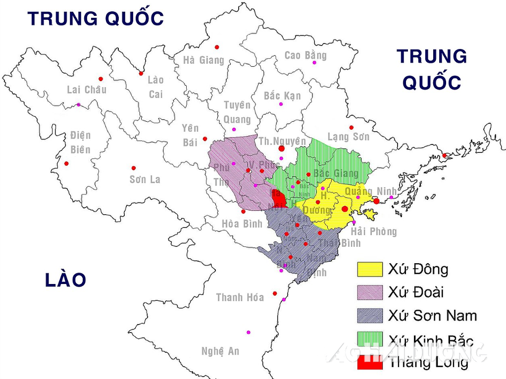
During the reign of Le Thanh Tong, in 1466, the country was divided into 12 provinces, Hai Duong belonged to Nam Sach province. In 1469, the whole country was mapped, Nam Sach province was changed to Hai Duong province, including 4 prefectures and 18 districts. Of which, Thuong Hong province had 3 districts: Duong Yen (An), Duong Hao and Cam Giang. Ha Hong province had 4 districts: Truong Tan, Tu Ky, Vinh Lai and Thanh Mien. Nam Sach province had 4 districts: Binh Ha, Tan An, Thanh Lam and Chi Linh. Kinh Mon province had 7 districts, also known as seven districts, including: Hiep Son, Dong Trieu, An Lao, Nghi Duong, Thuy Duong, Kim Thanh and An Duong.
Thus, the name Hai Duong began to appear in 1469.
In 1490, the map was redefined and changed to Hai Duong region, nicknamed Dong region. During the reign of Le Tuong Duc, Hong Thuan era (1509 - 1516), it was called Hai Duong town.
In the 12th year of Minh Mang (1831), towns were changed into provinces, and the whole country had 31 provinces. Hai Duong town was changed into Hai Duong province, also known as Dong province.
During the reign of King Tu Duc, the boundaries of Hai Duong province were as follows: from east to west, 66 km long, from south to north, 50 km long. To the east, it reached the boundary of Yen Hung district, Quang Yen province; to the west, it reached the boundary of Van Giang district, Bac Ninh province. To the south, it reached the two districts of Phuong Nhon and Que Duong, Bac Ninh province. To the southeast, it reached the Van Uc estuary (old name is Duong Uc), Tien Minh district; to the northeast, it reached the boundary of Hoanh Bo district, Quang Yen province; to the southwest, it reached the boundary of Phu Cu district, Hung Yen province; to the northwest, it reached the boundary of Luong Tai district, Bac Ninh province.
During the French colonial period (from August 1883 to August 1945), the place names and boundaries of Hai Duong had major changes. When Nguyen Canh Tong ascended the throne in the year of Binh Tuat (1886), he first issued an edict to avoid the word Duong, and Hai Duong had to change the names of three districts: Thuy Duong to Thuy Nguyen, Duong An to Nang An, and Duong Hao to My Hao. On September 11, 1887, the Governor-General of Indochina issued a decree to take An Duong, An Lao districts and 4 communes of Thuy Nguyen of Hai Duong to establish Hai Phong province.
On January 10, 1890, the Governor-General of Indochina issued a decree to establish Dong Trieu province, including the districts of Dong Trieu, Chi Linh, and Truc Dong (belonging to Dong Trieu and Yen Hung). On November 23, 1891, the Governor-General of Indochina issued a decree to abolish Dong Trieu province, and the old districts were returned to Hai Duong.
On August 24, 1891, the Governor-General of Indochina issued a decree to take some cantons of Dong Trieu, Chi Linh, and Luc Nam to establish Pha Lai Military Zone; merge the remaining cantons of Dong Trieu district into Hiep Son district, and the remaining cantons of Chi Linh district into Thanh Lam district.
On September 22, 1891, Thuy Nguyen district was merged into Hai Phong province.
On April 20, 1893, Tien Lang district was merged into Hai Phong province; some communes of 4 cantons of Kim Thanh district were merged into An Lao district, Hai Phong province; some communes of Hiep Son district were merged into Thuy Nguyen district and An Duong district, Hai Phong province.
On January 31, 1898, Hai Phong City separated from Hai Phong Province, the provincial capital was located in Phu Lien. On August 5, 1902, Hai Phong Province was changed to Phu Lien Province. On February 17, 1906, Phu Lien Province was changed to Kien An Province.
According to the book “Geography of the Northern Provinces” by Ngo Vi Lien, published in 1926, the boundaries of Hai Duong province at that time were as follows: to the east it bordered Quang Yen province, Hai Phong city, Kien An province; to the north it bordered Bac Giang province; to the west it bordered Bac Ninh and Hung Yen provinces; to the south it bordered Thai Binh province. The natural land area was about 2,200 km2, with a population of over 590 thousand people.
Boundaries and place names from August Revolution to present
The victory of the August Revolution in 1945 led to the establishment of a government apparatus throughout the country from the central to the grassroots level. Initially, in terms of administration, the local government consisted of the levels of the region (later changed to the ministry), province and centrally-run city, district, town and commune.
On November 22, 1945, the Provisional Government issued Decree No. 63/SL regulating the organization, powers, functions and tasks of the authorities at the commune, provincial, district and equivalent levels. According to Decree No. 63/SL, the authorities at the provincial, communal and equivalent levels have People's Councils and Administrative Committees. The provincial (ministerial) and district or equivalent levels only have Administrative Committees, not People's Councils. In early 1946, the districts proceeded to determine the boundaries of the communes. On April 26, 1946, the people of Hai Duong province went to the polls to elect the provincial People's Council and the communal People's Council.
On July 9, 1947, Chi Linh, Kinh Mon, Nam Sach, and Dong Trieu districts were transferred to Quang Yen province. On August 25, 1948, Nam Sach district was transferred from Quang Yen province back to Hai Duong province.
On January 10, 1949, Kinh Mon district of Quang Yen was transferred to Hai Duong province. On November 7, 1949, Thuy Nguyen district of Kien An province and Nam Sach and Kinh Mon districts of Hai Duong province were cut to Quang Yen province.
On May 2, 1952, Vinh Bao district was transferred from Hai Duong province to Kien An province. On February 22, 1955, Nam Sach, Chi Linh, Kinh Mon districts of Quang Yen province were returned to Hai Duong province.
From 1961, the boundaries of Hai Duong province remained the same until it merged with Hung Yen province to form Hai Hung province. The administrative units include Hai Duong town and 11 districts: Chi Linh, Nam Sach, Kinh Mon, Kim Thanh, Thanh Ha, Cam Giang, Binh Giang, Thanh Mien, Gia Loc, Tu Ky, Ninh Giang. The whole province has 247 communes, 6 urban areas, and 4 towns.
On January 26, 1968, implementing Resolution 504-NQ/TVQH of the National Assembly Standing Committee, Hai Duong and Hung Yen provinces merged into Hai Hung province. Hai Hung province borders Ha Bac province to the north; Thai Binh and Ha Nam Ninh provinces to the south and southwest; and Hai Phong city to the east. Hai Hung has an area of 2,554.72 km2, with administrative units including 2 towns (Hai Duong town, Hung Yen town) and 20 districts: Chi Linh, Kinh Mon, Nam Sach, Kim Thanh, Thanh Ha, Gia Loc, Tu Ky, Cam Giang, Binh Giang, Thanh Mien, Ninh Giang (belonging to the old Hai Duong province) and Van Lam, Van Giang, My Hao, Yen My, Khoai Chau, An Thi, Kim Dong, Phu Cu, Tien Lu (belonging to the old Hung Yen province).
On November 6, 1996, the 10th Session of the 9th National Assembly issued a Resolution to separate Hai Hung province into Hai Duong province and Hung Yen province from January 1, 1997.
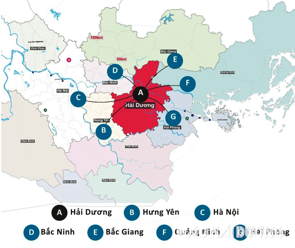
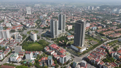
Up to now, Hai Duong province has a natural area of 1,668 km², a population of over 2.15 million people, including 2 cities, 1 town and 9 districts. According to the draft resolution on administrative unit arrangement of the National Assembly Standing Committee advised by the Ministry of Home Affairs, Hai Duong is one of 52 other provinces and cities that must be merged in the coming time.
Source: https://baohaiduong.vn/nhung-lan-thay-doi-dia-gioi-hai-duong-tu-the-ky-15-den-nay-408311.html

![[Photo] Readers line up to visit the photo exhibition and receive a special publication commemorating the 135th birthday of President Ho Chi Minh at Nhan Dan Newspaper](https://vphoto.vietnam.vn/thumb/1200x675/vietnam/resource/IMAGE/2025/5/17/85b3197fc6bd43e6a9ee4db15101005b)
![[Photo] More than 17,000 candidates participate in the 2025 SPT Competency Assessment Test of Hanoi National University of Education](https://vphoto.vietnam.vn/thumb/1200x675/vietnam/resource/IMAGE/2025/5/17/e538d9a1636c407cbb211b314e6303fd)

![[Photo] Prime Minister Pham Minh Chinh chairs meeting on science and technology development](https://vphoto.vietnam.vn/thumb/1200x675/vietnam/resource/IMAGE/2025/5/17/ae80dd74c384439789b12013c738a045)


![[Photo] Nearly 3,000 students moved by stories about soldiers](https://vphoto.vietnam.vn/thumb/1200x675/vietnam/resource/IMAGE/2025/5/17/21da57c8241e42438b423eaa37215e0e)


Comment (0)