
According to statistics from the Provincial Steering Committee for Natural Disaster Prevention, Search and Rescue and Civil Defense, by the evening of July 23, many roads in the province had landslides and rolling rocks at 50 locations with a volume of about 1,700 m3 .

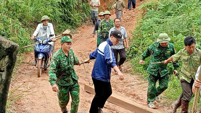
Heavy rain caused landslides on the road from Pu Nhi to Muong Chanh (Muong Lat).
Accordingly, National Highway 15C has 14 locations, National Highway 16 has 8 locations, National Highway 217 has 25 locations, National Highway 47 has 2 locations; National Highway 15 has 1 location.
Negative slope landslides at 3 locations with a length of 40m, specifically: QL.16 has 1 location, QL.217 has 2 locations.
For provincial roads, the slopes are eroded at 52 locations with a volume of about 4,650 m3 , specifically: DT.521D has 1 location, DT.521E has 7 locations, DT.530 has 3 locations, Pu Nhi - Muong Chanh has 24 locations, the border patrol road has 17 locations (Pu Nhi - Muong Chanh road alone has a location at Km8+150 causing traffic jams and Km9+745 where only motorbikes can pass in Pu Nhi commune, Muong Lat district). In addition, many national highways, DTs and rural traffic routes have landslides, silting of road surfaces, ditches, sewers...

Landslides damaged houses of households in Na Meo commune (Quan Son).
Regarding housing, 8 houses were affected and damaged (of which, 4 houses in Muong Lat district, 2 houses in Quan Son, 2 houses in Quan Hoa). In agriculture , 262.4 hectares of rice were flooded and damaged (13.7 hectares in Muong Lat; 1.3 hectares in Quan Son; 247.4 hectares in Nga Son). The cultural house of Xop Huoi village (Na Meo commune, Quan Son district) had a landslide on the negative slope close to the house foundation; 20m of embankment at Sa Na village (Na Meo commune, Quan Son district) was eroded; 110m of plastic water pipes of the people were swept away; the slope (about 100m3 of soil and rock) behind the cultural house of Chieng Cam village, Hien Kiet commune (Quan Hoa).

Flood water flows rapidly at Pu stream, water overflows the spillway causing damage to houses of people in Thanh Son commune (Quan Hoa).
Immediately after the disaster occurred, local authorities organized inspection teams to direct the work of overcoming the consequences and quickly stabilize the lives of people affected by the disaster. At the same time, they directed organizations to mobilize forces to help affected families clean up and repair damaged houses; guide people to repair and care for damaged crops; promptly compile statistics on the damage and propose support needs to quickly overcome the consequences caused by natural disasters.

Bac Song Ma Irrigation Company Limited operates Ha Giang Pumping Station (Ha Trung) to drain floodwaters for autumn rice.
To mitigate natural disasters, the province is operating 20 pumping stations. Of which: Ha Trung district operates 9 stations, Bac Song Ma Irrigation Company Limited 11 stations. The Provincial Border Guard Command coordinates with coastal local authorities and related units to call and guide boats to safe shelters or away from dangerous areas. Hydroelectric reservoirs on the main stream of the Ma River have operated flood discharge to lower the reservoir water level to ensure safety of the works according to current regulations.
Le Hoi
Source: https://baothanhhoa.vn/thanh-hoa-nhieu-tuyen-giao-thong-bi-sat-lo-do-mua-lu-gay-ra-220354.htm


Comment (0)