
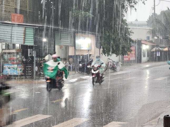
TPO - On the morning of November 13th, many areas in Ho Chi Minh City experienced widespread heavy rain, accompanied by thunderstorms, lightning, and strong gusts of wind.
TPO - On the morning of November 13th, many areas in Ho Chi Minh City experienced widespread heavy rain, accompanied by thunderstorms, lightning, and strong gusts of wind.
According to observations by Tien Phong reporters, at 9:00 AM this morning, November 13th, heavy rain occurred in the eastern and central areas of Ho Chi Minh City. Subsequently, the thunderstorm cloud system continued to develop and caused very heavy rain in neighboring districts and counties such as District 8, Binh Tan District, and Binh Chanh County,...
"I was riding my motorbike on the road when it suddenly started raining heavily, causing many people to seek shelter for fear of the storm posing a danger," shared Mr. Le Van Phong (resident of District 8).
Video: Heavy rain in Ward 16, District 8, Ho Chi Minh City on the morning of November 13th. |
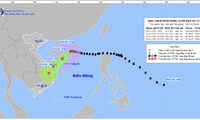
According to the National Center for Hydrometeorology, monitoring of satellite cloud imagery, lightning location data, and weather radar images shows that convective clouds are still present and developing over the areas of Cam My and Long Khanh town ( Dong Nai province); Can Gio (Ho Chi Minh City); and Tan Thanh (Ba Ria - Vung Tau province).
Forecasts indicate that over the next 3 hours, these convective clouds will continue to cause showers and thunderstorms in the aforementioned area, then expand to neighboring areas. During thunderstorms, there is a possibility of tornadoes, lightning, hail, and strong gusts of wind.
 |
The meteorological agency forecasts that in mid-November, disturbances in the easterly wind zone are likely to cause showers and thunderstorms in the Ho Chi Minh City area for about 1-2 days. (Illustrative photo: Pham Nguyen) |
According to the Southern Vietnam Regional Meteorological and Hydrological Station, Ho Chi Minh City and several southern provinces and cities are currently experiencing thunderstorms. The weather pattern causing the rain is influenced by several factors. These include a weakening continental cold high-pressure system moving eastward, an equatorial trough with its axis at approximately 4-7 degrees North latitude, and a tropical depression weakened from Typhoon No. 7 operating in the sea west of the Hoang Sa archipelago, connected to the circulation of Typhoon Tojari in the sea off the eastern coast of the Philippines. At higher altitudes, a strong subtropical high-pressure system is active over Central Vietnam.
During mid-November, forecasts indicate that cold air masses will intensify and spread southward. These intensifications will be accompanied by disturbances in the easterly wind zone, potentially causing showers and thunderstorms in Ho Chi Minh City for 1-2 days.


Source: https://tienphong.vn/mua-trang-troi-o-tphcm-post1691096.tpo


![[Photo] President Luong Cuong presides over the welcoming ceremony for the President of the European Council, Antonio Costa.](/_next/image?url=https%3A%2F%2Fvphoto.vietnam.vn%2Fthumb%2F1200x675%2Fvietnam%2Fresource%2FIMAGE%2F2026%2F01%2F29%2F1769662707713_ndo_br_1-jpg.webp&w=3840&q=75)


![OCOP during Tet season: [Article 4] Elevating local products](/_next/image?url=https%3A%2F%2Fvphoto.vietnam.vn%2Fthumb%2F402x226%2Fvietnam%2Fresource%2FIMAGE%2F2026%2F01%2F29%2F1769652810578_2935-z6982071462129_649e82db06fb2f2ea701388b1f5f5b0b-173322_176-185229-202804_457.jpeg&w=3840&q=75)


![OCOP during Tet season: [Part 3] Ultra-thin rice paper takes off.](/_next/image?url=https%3A%2F%2Fvphoto.vietnam.vn%2Fthumb%2F402x226%2Fvietnam%2Fresource%2FIMAGE%2F2026%2F01%2F28%2F1769562783429_004-194121_651-081010.jpeg&w=3840&q=75)

![OCOP during Tet season: [Part 2] Hoa Thanh incense village glows red.](/_next/image?url=https%3A%2F%2Fvphoto.vietnam.vn%2Fthumb%2F402x226%2Fvietnam%2Fresource%2FIMAGE%2F2026%2F01%2F27%2F1769480573807_505139049_683408031333867_2820052735775418136_n-180643_808-092229.jpeg&w=3840&q=75)


Comment (0)