
While the cold air mass that came 2-3 days ago has weakened significantly, around the night of January 14, a new wave will strengthen. The temperature in the North is forecast to drop to below 5 degrees Celsius, with the possibility of frost.
According to the National Center for Hydro-Meteorological Forecasting, currently (January 13), in the North, a cold air mass is moving south.
Around tomorrow night (January 14), this cold air mass will affect the Northeast region, then affect the North Central region, Northwest region and Central Central region. Northeast wind inland will strengthen to level 2-3, coastal areas level 3-4.
Due to the influence of the strengthening cold air, the weather in the North and the area from Thanh Hoa to Hue continues to be cold, the mountainous areas of the North are very cold, some places are very cold. The lowest temperature during this cold air wave in the North and North Central regions is generally 9-12 degrees, the mountainous areas of the North are 6-9 degrees, the high mountainous areas are below 5 degrees in some places; in the area from Quang Binh to Hue, it is generally 14-17 degrees.
Hanoi area is cold; the lowest temperature in this cold air mass is commonly 9-12 degrees.

At the same time, from tomorrow night, the area from Nghe An to Binh Dinh will have rain, showers, locally heavy rain and thunderstorms. During thunderstorms, there is a possibility of tornadoes, lightning and strong gusts of wind.
It is worth noting that the cold air has increased while the temperature of the January 9-10 period has not increased significantly, so when the new period comes, the temperature will decrease sharply, and the high mountainous areas will still have the possibility of frost, ice and frost.
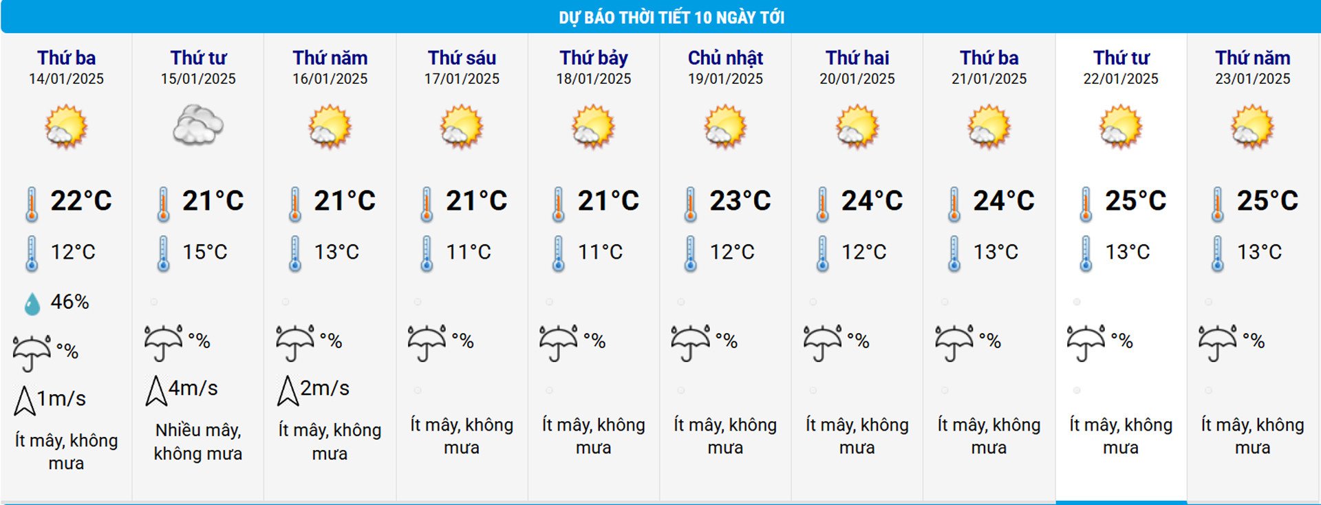
This cold spell is forecast to last for many days to come, but it will be mainly cold at night and early morning, with sunny days and temperatures fluctuating around 20 degrees, cold weather.
Regarding the weather at sea, from tomorrow night, in the Gulf of Tonkin, the Northeast wind will increase to level 6-7, gusting to level 8-9, rough seas, waves 2-4m high. In the North East Sea (including the waters of Hoang Sa archipelago), the Northeast wind will increase to level 7, gusting to level 9, rough seas, waves 3-5m high.
From January 15, in the Central East Sea, the sea area from Quang Tri to Binh Thuan, the Northeast wind will increase to level 6, sometimes level 7, gusting to level 8-9, rough seas, waves 3-5m high.
The meteorological agency noted that thunderstorms accompanied by tornadoes, lightning and strong gusts of wind can affect agricultural production, cause trees to fall, damage houses, traffic works and infrastructure.
Localized heavy rains can cause flooding in low-lying areas; flash floods in small rivers and streams, and landslides on steep slopes.
Strong winds and large waves at sea are likely to affect boating and other activities.
Severe cold, frost, ice and frost can affect crops and livestock.

Hanoi weather for the next 3 days: Cold air penetrates deeply and then weakens slowly

![[Photo] Prime Minister Pham Minh Chinh starts construction of vital highway through Thai Binh and Nam Dinh](https://vphoto.vietnam.vn/thumb/1200x675/vietnam/resource/IMAGE/2025/5/12/52d98584ccea4c8dbf7c7f7484433af5)


![[Photo] Prime Minister Pham Minh Chinh works with the Standing Committee of Thai Binh Provincial Party Committee](https://vphoto.vietnam.vn/thumb/1200x675/vietnam/resource/IMAGE/2025/5/12/f514ab990c544e05a446f77bba59c7d1)
![[Photo] Prime Minister Pham Minh Chinh receives Swedish Minister of International Development Cooperation and Foreign Trade](https://vphoto.vietnam.vn/thumb/1200x675/vietnam/resource/IMAGE/2025/5/12/ae50d0bb57584fd1bbe1cd77d9ad6d97)


Comment (0)