
Around the afternoon and night of March 15, a new cold air mass began to flow into our country, causing temperatures to drop sharply in the North to 13-16 degrees; the weather turned cold and dry with continuous sunshine.
According to the National Center for Hydro-Meteorological Forecasting, currently (March 13), a cold air mass is moving south from the North.
It is forecasted that from the afternoon and night of March 15, this cold air mass will affect the Northeast, North Central and some places in the Northwest, then other places in the Northwest, Central Central and some places in the South Central.
Inland, the wind changes direction to Northeast, gradually increasing to level 3-4, coastal areas level 4-5, with gusts of level 6 in some places.

Due to the influence of cold air, from the night of March 15, the weather in the North and North Central regions will turn cold, with some mountainous areas in the North experiencing severe cold; from around March 17, the weather will turn cold in the area from Quang Binh to Hue.
The meteorological agency said that the lowest temperature in this cold air mass in the North is generally from 13-16 degrees Celsius, in mountainous areas below 10 degrees Celsius; North Central 14-17 degrees Celsius; Quang Binh to Hue 17-19 degrees Celsius.
Particularly, Hanoi weather from the night of March 15th will turn cold. The lowest temperature in this cold air mass is commonly 14-16 degrees.
Meteorological experts predict that cold air will strengthen from the evening and night of March 15 to the early morning of March 16, so the Northern and North Central regions are likely to have scattered showers and thunderstorms.
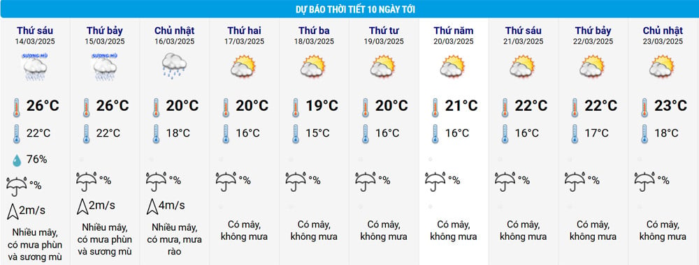
This cold spell will only cause rain in the North and North Central regions on March 16, then turn cold and dry for about 3-4 days. However, the temperature will be below 15 degrees Celsius mainly at night and early morning; during the day, it will remain around 20 degrees Celsius and there will be continuous sunshine, so it will not feel as cold as many previous cold spells. After that, the temperature in the region will likely increase rapidly until the end of next week, with the highest temperature in Hanoi being around 23 degrees Celsius and the lowest being 18 degrees Celsius.
In addition, the meteorological agency also forecasts that in March, cold air is likely to be more active than the average of many years, however, the continental cold high pressure center tends to shift east, causing many days of light rain, drizzle and fog in the Northeast and North Central regions. In April, cold air tends to weaken.
The meteorological agency noted that cold, severe cold, and severe cold can affect livestock and poultry and the growth and development of crops.
Thunderstorms accompanied by tornadoes, lightning, hail and strong winds can affect agricultural production, cause trees to fall, damage houses, traffic works and infrastructure.
Weather at sea Due to the influence of cold air, from the evening and night of March 15, in the Gulf of Tonkin, the wind will change direction to Northeast and gradually increase to level 7, gusting to level 9, rough seas, waves 2-3.5m high; in the North East Sea (including the sea area of Hoang Sa archipelago), the wind will be strong Northeast at level 6-7, gusting to level 8-9, rough seas, waves 3-5.5m high. From the night of March 16, the sea area from Quang Tri to Ca Mau will have strong Northeast winds at level 6, gusting to level 7-8, rough seas; waves 2-4m high. Strong winds and large waves at sea are likely to affect boating and other activities. |
Source: https://vietnamnet.vn/khong-khi-lanh-sap-do-bo-mien-bac-chuyen-ret-kem-nang-lien-tiep-2380431.html

![[Photo] Prime Minister Pham Minh Chinh works with the Standing Committee of Thai Binh Provincial Party Committee](https://vphoto.vietnam.vn/thumb/1200x675/vietnam/resource/IMAGE/2025/5/12/f514ab990c544e05a446f77bba59c7d1)


![[Photo] Prime Minister Pham Minh Chinh receives Swedish Minister of International Development Cooperation and Foreign Trade](https://vphoto.vietnam.vn/thumb/1200x675/vietnam/resource/IMAGE/2025/5/12/ae50d0bb57584fd1bbe1cd77d9ad6d97)
![[Photo] Prime Minister Pham Minh Chinh starts construction of vital highway through Thai Binh and Nam Dinh](https://vphoto.vietnam.vn/thumb/1200x675/vietnam/resource/IMAGE/2025/5/12/52d98584ccea4c8dbf7c7f7484433af5)


Comment (0)