
 |
| Real-time monitoring station for landslide disasters at Ong Tuong hill, Hoa Binh city, Hoa Binh province |
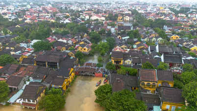
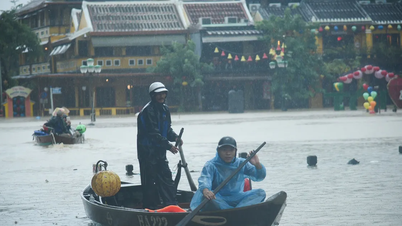
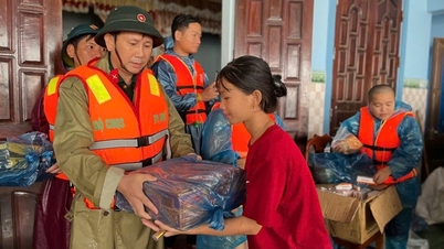
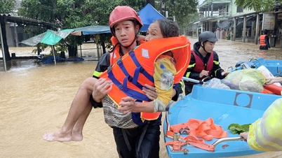
It is not yet known when the accident occurred.
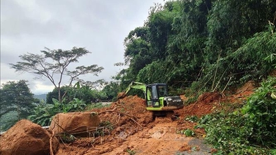
Assessing the geology of the northern mountainous region, Associate Professor, Dr. Tran Tuan Anh, Vice President of the Vietnam Academy of Science and Technology, Director of the Institute of Geology, said that most of the northern mountainous region is made up of ancient rocks that have been strongly weathered. The weathered crust like soil reaches a depth of 15m-30m. This crust often contains clay minerals (especially montmorillonite) that change their properties very strongly, especially swelling greatly when there is water, determining the easy deformation and disintegration properties of this type of soil.
In the summer of 2024, the North suffered a prolonged heat wave (from April to July), and the soil structure was significantly damaged. This was followed by consecutive long rains in August and early September due to the influence of storm No. 3, which weakened the soil structure and made it easily saturated and muddy when exposed to water. Mountainous slopes are naturally stable, but when exposed to the above unfavorable conditions, the soil's strength is reduced, and they will collapse, burying everything at the foot of the slope. When the slope is high, large volumes of soil collapse, causing very serious consequences.
 |
| Associate Professor, Dr. Tran Tuan Anh, Vice President of Vietnam Academy of Science and Technology, Director of Institute of Geology |
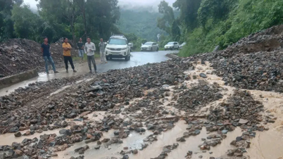
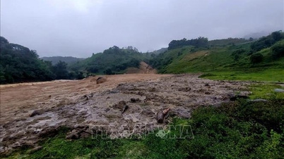
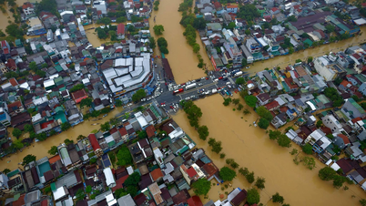
In addition, flash floods often occur in mountainous provinces during the rainy season. Flash floods occur when two factors occur simultaneously: the presence of loose, poorly bonded rocks and soil in the path of the flow and the appearance of a flow with a speed large enough to sweep away these rocks and soil. After a long period of rain, rocks and soil on the mountainside slide down the stream, accumulate to form a natural dam, forming a lake on the mountain, causing rocks and soil at the bottom and walls of the lake to be soaked for a long time. When the rain continues for a long time, the amount of accumulated water increases, causing the dam to break, creating a flood with a mixture of water, mud, rocks and trees flowing rapidly, destroying all obstacles in the path of the flood.
One of the issues that many people are concerned about is whether it is possible to give early warning of flash floods and landslides? According to Associate Professor, Dr. Tran Tuan Anh, there are currently many technologies and methods for early warning of flash floods, landslides and geological disasters, but they are often effective on a small scale.
For early warning of landslides, methods can be used such as: Installing automatic monitoring equipment to record the displacement of the sliding block. When this displacement exceeds the limit that can cause a disaster, the system will notify the authorities and people to evacuate from the dangerous area in time. However, the limitation of this method is that in the entire mountainous area of Vietnam, there are countless slopes and mountain slopes at risk of landslides, we do not have enough funds and human resources to do this work. On the other hand, in many places where there is no mobile phone signal, no internet, no electricity system, the work of transmitting signals to the warning analysis center cannot be done.
Regarding early warning of flash floods, due to the characteristics of rapid and unexpected occurrence (flash floods often occur in a short period of time from 40 minutes to 1 hour and 30 minutes), early warning of flash floods still faces many difficulties, scientific and technological research is still in the testing phase.
According to scientists, there is a simple way to warn of flash floods early. During the rainy season, observe the normal stream water level and suddenly see it suddenly drop, or the stream water suddenly becomes unusually cloudy. This is a sign that a flash flood is about to happen and you need to evacuate immediately.
Currently, to warn of landslides, flash floods and other geological disasters, we are still using disaster risk warning maps researched and built by scientists. These maps indicate areas at risk of natural disasters at different levels, but do not indicate the time when the disaster will occur.
Need to plan residential areas to avoid landslides and flash floods
Although recent serious landslides such as in Lao Cai, Yen Bai , Son La... have been recorded in the flash flood disaster zoning map, the work of preventing and mitigating damage is still not effective.
According to Associate Professor, Dr. Tran Tuan Anh, there are many reasons such as:
Firstly, the disaster risk assessment maps were built at a scale of 1:1,000,000, or 1:500,000, or 1:250,000 (meaning 1cm on the map is equivalent to 10km, or 5km, or 2.5km in the field), so these maps do not show slopes, streams at risk of landslides or flash floods when it rains to alert the locality. Detailed locations at risk of landslides and flash floods require a lot of resources and time to compile and assess in detail.
Second, long-term forecasting of storm levels and rainfall, where they will occur, and the duration of long periods of heavy rain is quite good, but the level of accuracy and detail needs to be further improved. In addition, the timing and amount of rain that causes landslides and flash floods in specific areas cannot be fully measured, so when natural disasters occur, they are surprising and passive for the locality.
Third, due to the lack of disaster risk scenarios to serve response and search and rescue work, when natural disasters occur, localities are somewhat passive.
Presenting solutions to minimize damage caused by landslides and flash floods in mountainous areas, Associate Professor, Dr. Tran Tuan Anh said that localities need to have statistics at the village level on the number of slopes and streams at risk of causing landslides and flash floods, through research and development of maps to assess the risk of landslides and flash floods occurring in the locality at a scale of 1:5,000 or 1:10,000.
Localities, especially mountainous localities, need to develop disaster risk scenarios at the village and hamlet level, indicating the direction of disaster risks, escape routes, and search and rescue plans when disasters occur.
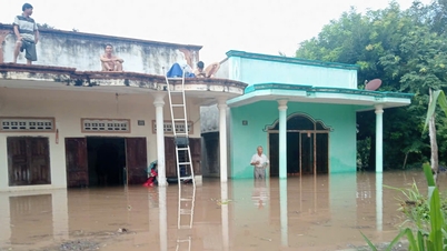
At the same time, it is necessary to plan residential areas to avoid landslides and flash floods. For landslides, it is advisable to choose to build residential areas away from the influence of slopes. If residential areas are forced to live near slopes, the slopes need to be reinforced with solid retaining walls and install an early warning system for landslides.
An effective and economical solution to prevent flash floods is to plan safe living spaces, not in places where the flow is directed straight into residential areas (plan residential areas on small curved banks of streams); plan residential areas only on one side of the stream (high banks are better). There, it is possible to build bank protection works, the low bank strip is not built, is the land fund used for farming production and is a flood escape space to reduce flood energy when natural disasters occur.
In addition to the objective factors of nature, we also need to fully understand sustainable development; it is necessary to balance economic benefits and the stability of the natural environment.
Source: https://baothuathienhue.vn/kinh-te/khoa-hoc-cong-nghe/kho-khan-trong-ung-dung-cong-nghe-canh-bao-som-sat-lo-lu-quet-146048.html

![[Photo] Draft documents of the 14th Party Congress reach people at the Commune Cultural Post Offices](https://vphoto.vietnam.vn/thumb/1200x675/vietnam/resource/IMAGE/2025/10/28/1761642182616_du-thao-tai-tinh-hung-yen-4070-5235-jpg.webp)
![[Photo] Flooding on the right side of the gate, entrance to Hue Citadel](https://vphoto.vietnam.vn/thumb/1200x675/vietnam/resource/IMAGE/2025/10/28/1761660788143_ndo_br_gen-h-z7165069467254-74c71c36d0cb396744b678cec80552f0-2-jpg.webp)


![[Photo] National Assembly Chairman Tran Thanh Man received a delegation of the Social Democratic Party of Germany](https://vphoto.vietnam.vn/thumb/1200x675/vietnam/resource/IMAGE/2025/10/28/1761652150406_ndo_br_cover-3345-jpg.webp)


![[Photo] President Luong Cuong attends the 80th Anniversary of the Traditional Day of the Armed Forces of Military Region 3](https://vphoto.vietnam.vn/thumb/1200x675/vietnam/resource/IMAGE/2025/10/28/1761635584312_ndo_br_1-jpg.webp)


Comment (0)