
Latest news on tropical depression about to strengthen into storm number 4
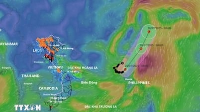
According to the National Center for Hydro-Meteorological Forecasting, at 4:00 a.m. on September 18, the center of the tropical depression was located at about 16.7 degrees North latitude; 113.8 degrees East longitude, about 250km east of Hoang Sa archipelago. The strongest wind near the center of the tropical depression was level 7 (50-61km/h), gusting to level 9; moving mainly westward at a speed of about 25km/h.
It is forecasted that in the next 24 hours, the tropical depression will likely strengthen into a storm, level 8 intensity, gusting to level 10.
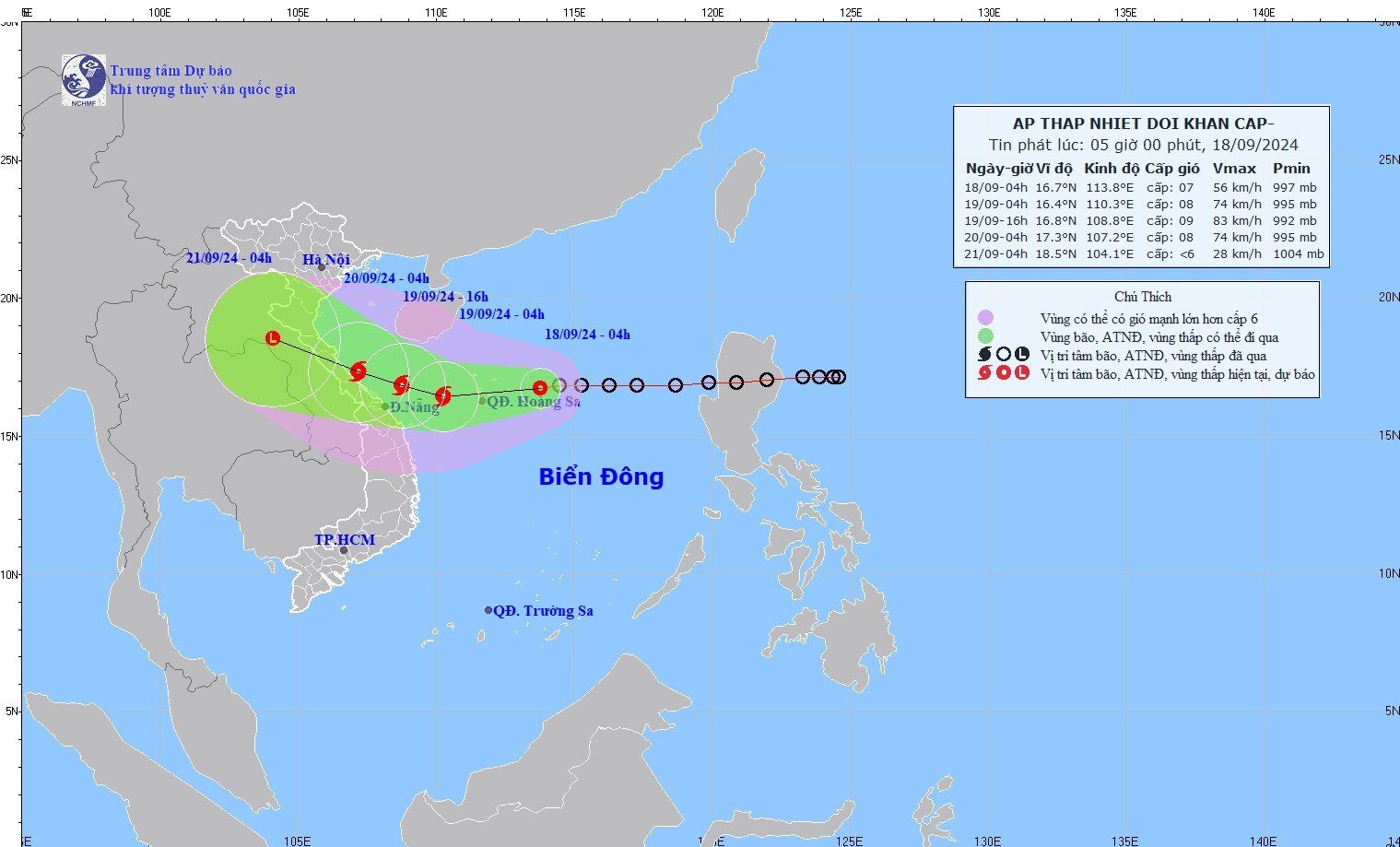
The movement of the tropical depression, which is likely to strengthen into storm No. 4. Photo: nchmf.
Forecast time | Direction, speed | Location | Intensity | Danger zone | Disaster Risk Level (Affected Area) |
04h/19/9 | West Southwest, 15-20km/h, strengthening into a storm | 16.4 N-110.3E, about 340km from the mainland of Quang Binh province to Da Nang to the East Southeast | Level 8, level 10 | 15.0N-19.0N; 109.0E-115.5E | Level 3: Western sea area of the North East Sea (including Hoang Sa archipelago); sea area from Quang Tri to Quang Ngai (including Ly Son island, Cu Lao Cham, Con Co) |
04h/20/9 | West Northwest, about 15km/h | 17.3N-107.2E; on coastal areas from Quang Binh to Da Nang provinces | Level 8, level 10 | 15.0N-19.0N; West of longitude 111.5E | Level 3: Western sea area of the North East Sea (including Hoang Sa archipelago); sea area from Nghe An to Quang Ngai (including Ly Son island, Cu Lao Cham, Con Co, Hon Ngu) |
In the next 48 to 72 hours, the storm will move in the West-Northwest direction, traveling 10-15km per hour and weaken into a low pressure area over Central Laos.
Warning of the impact of tropical depression/storm No. 4
The North East Sea area (including Hoang Sa archipelago), the sea area from Nghe An to Quang Ngai (including Ly Son island district, Cu Lao Cham, Con Co, Hon Ngu) has strong winds of level 6-7, the area near the storm center has level 8 (62-74km/h), gusts of level 10 (89-102km/h), waves 2.0-4.0m high, the area near the storm center has 3.0-5.0m, rough seas.
Vessels operating in the above mentioned dangerous areas are susceptible to the impact of storms, whirlwinds, strong winds and large waves.
On land: From early morning and September 19, coastal mainland areas from Ha Tinh to Quang Ngai will have winds gradually increasing to level 6-7, near the storm center level 8 (62-74km/h), gusting to level 10 (89-102km/h); deep inland there will be gusts of level 6-7.
From September 18 to September 20, in the North and Central Central regions, there will be heavy to very heavy rain with common rainfall from 100-300mm, locally over 500mm. From September 18 to September 19, the Central Highlands and the South will have moderate rain, heavy rain and thunderstorms, locally very heavy rain with common rainfall from 40-80mm, some places over 150mm (rain concentrated in the afternoon and night).


![[Photo] General Secretary To Lam receives the Director of the Academy of Public Administration and National Economy under the President of the Russian Federation](/_next/image?url=https%3A%2F%2Fvphoto.vietnam.vn%2Fthumb%2F1200x675%2Fvietnam%2Fresource%2FIMAGE%2F2025%2F12%2F08%2F1765200203892_a1-bnd-0933-4198-jpg.webp&w=3840&q=75)


Comment (0)