
Extend to Tay Ninh
Sun Group has just sent to the Ho Chi Minh City People's Committee its comments on the Project to adjust the general planning of Ho Chi Minh City to 2040, with a vision to 2060. Accordingly, Ho Chi Minh City needs to add to the planning an 8-10 lane wide boulevard along the Saigon River, connecting to Binh Duong and Tay Ninh. The focal point is the light rail line connecting directly to Tay Ninh, making trade between Ho Chi Minh City and Tay Ninh and the provinces along the Saigon River increasingly convenient.

Ho Chi Minh City needs to add to the planning an 8-10 lane boulevard along the Saigon River, connecting with Binh Duong and Tay Ninh.
The light rail line (LRT) will run along the Saigon River, connecting directly to Tay Ninh with a length of nearly 100 km, creating a continuous tourism development corridor, promoting the economy and society of the entire Southeast region to develop commensurate with its potential.
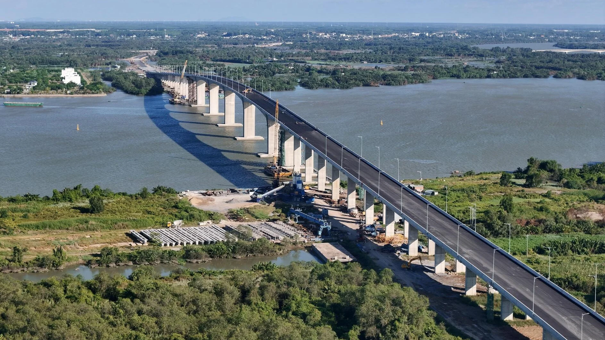
According to the project to adjust the general planning of Ho Chi Minh City to 2040 with a vision to 2060, Ho Chi Minh City will have a 3-4 lane traffic route along the Saigon River, with a total length of 78.2 km.
However, to anticipate future development potential, Sun Group proposes the need to develop a synchronous transportation network, with 8-10 lane boulevards, connecting Saigon with Binh Duong and Tay Ninh, following the Saigon River, creating extensive connections with the Southeast provinces.
Specifically, the route to Tay Ninh follows Provincial Road 6 (belonging to Ho Chi Minh City) towards Tay Ninh, then connects to Provincial Road 789 (belonging to Tay Ninh province). This is National Highway 22C according to the orientation of developing the Southeast region's transport network in the period of 2021 - 2030, with a vision to 2050.
Notably, the light rail line (LRT) running along the Saigon River route will not only stop at Cu Chi district as planned in the planning but will extend the entire route to Tay Ninh, nearly 100 km long.
Thus, the light rail line (LRT) will add a new type of transport along with waterways and roads, completing the economic and tourism development corridor of the Southeast region, expanding trade activities between Saigon and Binh Duong and Tay Ninh.
According to the presentation from Sun Group, this will help reduce traffic pressure on the existing road, reduce traffic jams, and provide more options for residents and tourists. When put into operation, the new light rail line will connect Saigon with attractive destinations in Tay Ninh, promoting the development of Tay Ninh tourism.
Mr. Hoang Anh Tu - Project Director of BCG Vietnam Group - affirmed: "Investing in a 4-10 lane boulevard, including a mixture of roads and urban railways connecting from Ho Chi Minh City through Cu Chi to Tay Ninh is necessary, keeping up with the trend of developing metropolises in the world. From there, it is possible to open up a direction for tourism, urban and commercial development with the highlight being rivers, eliminating bottlenecks, promoting the potential of Tay Ninh and better connecting with Ho Chi Minh City".
Economic chain linkage axis
According to Architect Tran Ngoc Chinh - Chairman of the Vietnam Urban Development Planning Association, the development of high-class tourism infrastructure and modern transport infrastructure including waterways, roads, and parallel railways connecting Ho Chi Minh City - Cu Chi - Ba Den Mountain - Tay Ninh in the future Ho Chi Minh City planning project will create a vibrant "on the wharf, under the boat" space for the Saigon River corridor.
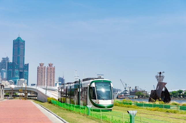
The light rail line (LRT) will complete the economic and tourism development corridor of the Southeast region.
“If this economic axis is implemented, it will solve the problems of transportation, logistics and population organization, forming an inter-regional tourism ecosystem chain, creating conditions for Tay Ninh to develop. This development axis also passes through Ba Den Mountain - the roof of the Southeast region. Therefore, this axis is not only an international economic chain link, but also needs to be the tourism “backbone” axis for Ho Chi Minh City,” said Mr. Chinh.
In addition to the proposal to invest in new transport infrastructure, Sun Group also contributed ideas on the development planning of areas with rich cultural, tourism and urban potential in Saigon, such as Rach Chiec Sports Complex, Vietnam Ethnic Culture and History Park (Thu Duc City), Cu Chi Safari... and urban areas with the Saigon River as the center such as Thanh Da - Binh Quoi Urban Area (Binh Thanh District), Truong Tho Urban Area (Thu Duc City), urban areas along the Saigon River in Cu Chi District and Hoc Mon District according to each subdivision.
“The proposals of Sun Group are expected to contribute to promoting the development of Ho Chi Minh City, awakening the vitality of the Saigon River, activating tourism potential, establishing the position of a leading socio-economic locomotive for Ho Chi Minh City in relation to the Southeast region. The new ideas when implemented will create new momentum, bringing Ho Chi Minh City to comprehensive development”, said a representative of Sun Group.
Source TPO
Source: https://baotayninh.vn/he-lo-doanh-nghiep-vua-de-xuat-lam-100km-duong-sat-nhe-tu-tphcm-di-tay-ninh-a180235.html


![[Photo] Prime Minister Pham Minh Chinh chairs conference on anti-smuggling, trade fraud, and counterfeit goods](https://vphoto.vietnam.vn/thumb/1200x675/vietnam/resource/IMAGE/2025/5/14/6cd67667e99e4248b7d4f587fd21e37c)


Comment (0)