
Accordingly, land lot H2CC1 belongs to the detailed planning of the central area of Tay Ho Tay urban area, scale 1/500, within the administrative boundary of Xuan Tao ward, Bac Tu Liem district.
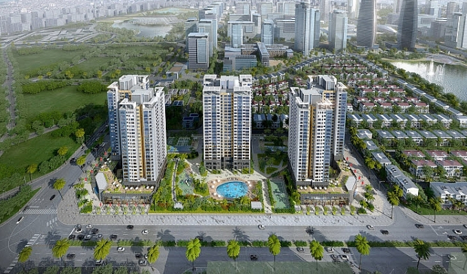
Adjusting the detailed planning of the West Lake urban area. Photo: IT
The North side borders the existing road with a 40m wide cross-section; the East side borders the green land lot coded H2CX1; the South side borders the existing road with a 15m wide cross-section; the West side borders the existing road with a 15m wide cross-section.
The total area of land lot H2CC1 is about 3,946m2. The local adjustment of the detailed planning at land lot H2CC1 is based on the principle of maintaining the location, boundary scope and architectural planning indicators (land lot area, construction density, land use coefficient, height of above-ground buildings) determined according to the approved Master Plan for Adjusting the Detailed Planning of the Central Area of Tay Ho Tay Urban Area at a scale of 1/500.
Land use functions are determined in accordance with the approved orientation of the H2-1 Urban Zoning Plan, scale 1/2000 (including the functions of public land of the city, areas and isolated green land (corridor to protect raw water wells).
In addition, the City People's Committee specifically determines the total construction floor area index in the project to comply with the provisions of QCVN 01:2021/BXD; supplement the project's function from transaction office to office, trade, and service to comply with the land use function according to the approved orientation of the Zoning Plan and related detailed Plan.
The Hanoi People's Committee requires that when establishing investment projects and implementing construction, relevant units must conduct specific surveys on the current status of land use, existing underground and underground works at the project and related ones according to State regulations, and must ensure general drainage for the area.
Adjusting the organization of landscape architecture space on the plot of land, specifically rearranging the layout of the complex of works on the plot of land in a simple and modern form, ensuring independent use functions suitable for the needs of project exploitation and operation.
The number of floors of the building is kept at 16 floors. Although there are changes compared to the layout of the building in the architectural landscape space organization diagram according to the detailed planning project at a scale of 1/500 approved by the City People's Committee, the general planning solution is basically still maintained.
When designing the architectural plan of a project, it is necessary to ensure the architectural planning indicators according to the controlled expenditure contents in the Master Plan of Land Use and the landscape architectural space organization diagram, the regulations of Vietnam Construction Standards, specialized design standards, other relevant current regulations and must be approved by the competent authority according to regulations.
Relevant units research solutions for beautiful and modern architectural design of the project (architectural details, colors, facade architectural forms, finishing decorative materials, lighting...) suitable for the usage function, harmoniously connecting with the landscape architectural space of surrounding projects and in the West Lake urban center...
PV
Source


![[Photo] General Secretary To Lam and National Assembly Chairman Tran Thanh Man attend the 80th Anniversary of the Traditional Day of the Vietnamese Inspection Sector](https://vphoto.vietnam.vn/thumb/1200x675/vietnam/resource/IMAGE/2025/11/17/1763356362984_a2-bnd-7940-3561-jpg.webp)


Comment (0)