
(QBĐT) - Running along the length of Quang Binh province, the ancient highway is closely linked to the history of development and territorial expansion, reflecting the aspiration for national reunification.
As its name suggests, the "thousand-mile road" is a route connecting the regions of the country from North to South. Originating in the Northern Delta, the road gradually expanded towards the southernmost part of the country throughout history, with the section passing through Quang Binh province having a history spanning over 10 centuries.
A long history
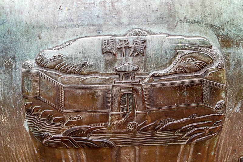
Starting from the northernmost point of the province at the southern slope of the Hoanh Son mountain range, in Quang Dong commune (Quang Trach), associated with the Hoanh Son Quan relic, bordering Ha Tinh province, the Thien Ly road runs along the coast to the southernmost point in Sen Binh village, Sen Thuy commune, Le Thuy district, bordering Quang Tri province. During the Early Le Dynasty, in 992, King Le Dai Hanh ordered troops to build a road from Ha Tinh to Dia Ly province. "In the autumn, in the 8th month, he ordered the regent Ngo Tu An to lead 30,000 people to open a road from Nam Gioi sea gate to Dia Ly province" (1). This is considered the first time point, marking the process of opening the Thien Ly road through Quang Binh. In 1402, Ho Quy Ly mobilized a large number of soldiers and laborers to open the Thien Ly road from Hoan Chau (Nghe An) to Hoa Chau (Hue).
Since gaining independence, the Early Le, Dinh, Ly, Tran, and Le dynasties have paid attention to expanding the main road to facilitate trade, connect between regions, and expand the territory. Because the main road was mainly used by officials, it was also called the main road. In 1776, when writing Phu Bien Tap Luc, Le Quy Don described the main road through Quang Binh very briefly, only the direction and the scenery on both sides of the road. "From Nghe An , going south, crossing Hoanh Son mountain, through Thuan Than, Phu Luu communes, Bo Chinh district, going east to Lu Dang commune, then to Gianh river" (2).
 |
After ascending the throne in 1801, along with consolidating the road system along the main highway, King Gia Long ordered the construction and repair of the main road section from the capital Phu Xuan to Dong Hai (now Dong Hai ward, Dong Hoi city). "Constructing the main road from Phu Xuan to Dong Hai" (3). In 1802, King Gia Long ordered the Minister of War Le Quang Dinh to consult books and maps of the whole country, the cities and towns from the Kinh Su region to the South to Ha Tien, and to the North to Lang Son, and to compile the book Hoang Viet Nhat Thong Du Dia Chi. The roads from Quang Binh province to the places in the provinces are listed in great detail and meticulously in the book Hoang Viet Nhat Thong Du Dia Chi. Also in this year, King Gia Long ordered the repair of roads and bridges. "Ordered the localities of Quang Duc, Quang Tri, and Quang Binh to repair the royal palace and bridges and roads" (4).
In the 9th year of Gia Long (1810), the court continued to repair bridges and culverts, straightening and filling the crooked sections of roads . "Repairing bridges and roads in the Quang Duc, Quang Tri, and Quang Binh provinces. The king saw that the old roads were crooked and muddy, so he ordered the city inspector Tran Van Hoc to measure the terrain, and had the people repair and fill them, providing them with daily food. He also saw that the summer weather was hot, so he warned against rushing the work too much, to ease the people's burden" (5). After 1 month, he ordered the repair of Ly Hoa bridge again . "Rebuilding Ly Hoa bridge in Quang Binh (The old bridge had 138 spans, now because the river is 74 trượng wide, 56 spans were rebuilt, reducing the old spans by 82), the commander Cao Cong Giang oversaw the work" (6).
In the first half of the 19th century, Nguyen dynasty kings such as Thieu Tri, Tu Duc... all took great care in consolidating, upgrading and perfecting the main road. In 1847, King Tu Duc approved the petition that “The Ministry of Public Works planned the handover. So along the road from Thua Thien to the North to Hanoi, the bridges, inns, and roads that the Qing dynasty envoys will leave behind, all local authorities must inspect thoroughly when they are free from public work in February of this year. Where there is damage, repair it; where there is collapse, build it up, so that it is uniformly durable.…” (7).
In Quang Binh province, there are “5 bridges, 168 stone culverts, water culverts, 4 ferry crossings, from the beginning of the border through Quang Loc, Quang Xa to the provincial capital. Then through Quang Ninh, Quang Cao, Quang Khe, Quang Yen to Hoanh Son province (the peak is more accurate - NV), the end of the border borders Ha Tinh province, including 6 stations” (8). Recognizing the role and importance of this vital transportation route, the Nguyen emperors paid great attention to building, consolidating, and expanding it, so the main road was gradually completed. In the section on roads in Quang Binh province, the book Dai Nam Nhat Thong Chi describes this road very briefly : “A main road, south bordering the Tri Lap station of Quang Tri province, north to Hoanh Son pass bordering the Tinh Than station of Ha Tinh province, 195 miles long” (9).
The main road
After invading our country, in order to implement the colonial exploitation program, the French colonialists began to build and upgrade the transportation system. Governor-General of Indochina Paul Doumer (term 1897-1902) was the initiator of this program, which included the construction of a railway, road and waterway transportation system. In his memoir "Indochina", Governor-General Paul Doumer described the main road section through Quang Binh province : "The main road passes through a pass right on the coast and then crosses the mountain ranges and extends continuously. That is the most unpleasant part of the whole road. Besides the stone steps that have to be climbed to go up and down the pass, we also have to cross a long stretch of quicksand, where the horses' hooves are buried in the sand up to their knees. ... We crossed the mountainous area that the Annamese call Ngang Pass" (10).
In 1912, the Governor-General of Indochina, Albert Sarraut (1872-1962), signed a decision to build a road network throughout Indochina. During his second term, on June 18, 1918, this Governor-General continued to issue a decree classifying the main road routes in Indochina and naming them successively as colonial roads, infiltration roads, and rural roads as commune roads. Colonial roads became the main axis of the road transport system in Vietnam in particular and throughout Indochina in general. "Specifically, the 'Colonial Road No. 1' passing through Quang Binh, the French mainly relied on the previous highway, surveyed and redesigned it, and completed the survey on the map in 1911" (11). The Indochina budget covered the construction and maintenance of this road. According to the decree of June 18, 1918, Indochina had 18 colonial routes, the most important of which was Colonial Route No. 1 (Route Coloniale N01), commonly known as the Thousand-Mile Route No. 1.
This road stretched from the Chinese border to the Thai border, connecting the capitals of the provinces of Tonkin, Annam, Cochinchina, and Cambodia. It was reinforced by the French colonialists, paved with compacted clay aggregate to the standards of a Class 5 road in the plains. Sections through the Ngang Pass and Ly Hoa Pass were rerouted to follow the mountain slopes, with a reduced gradient to facilitate easy access for vehicles. Smaller rivers were fitted with narrow, single-lane concrete bridges, such as the Roon Bridge and Ly Hoa Bridge. However, sections of the Nhat Le and Gianh rivers required 12-ton ferries to transport vehicles across, but instead of motorboats, each ferry was manned by eight rowers.
In 1913, this road began undergoing continuous repair and renovation. By January 1, 1930, the renovation was completed at a total cost of 19 million Indochinese francs. At this time, the road surface had been widened, and many bridges and culverts had been built to make travel easier and more convenient.
Colonial Road No. 1 was a continuation of the existing trans-Vietnam road network, later becoming National Highway 1. It was a special road that embodied the aspiration for national reunification, and the section through Quang Binh province is a shining example of that noble aspiration.
Nhat Linh
(1). Ngo Si Lien, Dai Viet History Chronicle, Hong Duc Publishing House, Hanoi, 2022, p.177.
(2) Le Quy Don, Phu Bien Tap Luc, Da Nang Publishing House, Da Nang, 2015, p.83.
(3), (4), (5), (6), National History Institute of the Nguyen Dynasty, Dai Nam Thuc Luc, Hanoi Publishing House, Hanoi, 2022, volume 1, pp. 459, 497, 786, 788.
(7), (8) Nguyen Dynasty Cabinet, Imperial Decree on the Regulations of Dai Nam, Thuan Hoa Publishing House, Hue, 2005, volume 7, p.326.
(9) National History Institute of the Nguyen Dynasty, Dai Nam Nhat Thong Chi, Labor Publishing House, 2012, volume 1, p.528.
(10) Paul Doumer, Indochina, The World Publishing House, Hanoi, 2019, p.371.
(11) Quang Binh Department of Transport, History of Transport in Quang Binh (1945-2015), Transport Publishing House, Hanoi, 2015, p.47.
Source: https://www.baoquangbinh.vn/van-hoa/202504/duong-thien-ly-tren-dat-quang-binh-2225585/


![OCOP during Tet season: [Part 3] Ultra-thin rice paper takes off.](/_next/image?url=https%3A%2F%2Fvphoto.vietnam.vn%2Fthumb%2F402x226%2Fvietnam%2Fresource%2FIMAGE%2F2026%2F01%2F28%2F1769562783429_004-194121_651-081010.jpeg&w=3840&q=75)


Comment (0)