
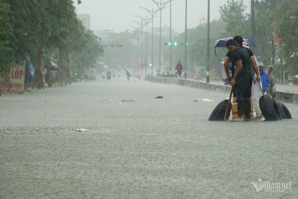
Weather forecast December 24, 2024, storm No. 10 causes heavy to very heavy rain for coastal areas from the Central provinces to Ho Chi Minh City.
In the past 6 hours, storm No. 10 has barely moved. Currently, the storm center is at about 11.4 degrees North latitude; 112.4 degrees East longitude, in the northwest area of Truong Sa archipelago. The strongest wind near the storm center is level 8 (62-74km/h), gusting to level 10.
At 10:00 p.m. on December 24, the storm moved in a West-Southwest direction at a speed of 5-10km/h. The center of the storm was located at about 11.2 degrees North latitude; 110.9 degrees East longitude, in the southwest sea area of the central East Sea. The strongest wind near the center of the storm was level 8, gusting to level 10. The dangerous area at sea was from 9.5 degrees North latitude to 13.5 degrees North latitude; from 110.0 degrees East longitude to 114.5 degrees East longitude. The disaster risk level was level 3 (high risk) for the northwest of the southern East Sea area (including the northwest sea area of the Truong Sa archipelago), the southwest sea area of the central East Sea.
By 10:00 p.m. on December 25, the storm was moving west-southwest at a speed of 5-10 km/h and gradually weakening into a tropical depression. The center of the storm was located at about 10.7 degrees North latitude; 109.3 degrees East longitude, on the sea from Phu Yen to Ba Ria-Vung Tau. The strongest wind near the center of the storm was at level 6, gusting to level 8. The dangerous area at sea was from 9.0 degrees North latitude to 12.5 degrees North latitude; from 109.0 degrees East longitude to 112.5 degrees East longitude.
Level 3 natural disaster risk (high risk) for the sea area from Phu Yen to Ba Ria-Vung Tau; the sea area southwest of the central East Sea, the sea area northwest of the southern East Sea (including the sea area northwest of Truong Sa archipelago).
Storm No. 10 is forecast to cause moderate to heavy rain, and in some places very heavy rain and thunderstorms in the central coastal provinces from December 24. Provinces from Thua Thien Hue to Ba Ria - Vung Tau need to be on guard against the risk of flash floods, landslides, and inundation in low-lying areas.
Weather forecast 12/24/2024 in detail for regions across the country:
The capital welcomes a new day with cold weather. Cloudy, no rain at night, early morning fog and scattered light fog, sunny during the day. Northeast wind level 2-3. Lowest temperature 13-15 degrees, highest 21-23 degrees.
Northwest
The Northwest region is cold, with some places experiencing severe cold, with the possibility of frost and frost in mountainous areas. Cloudy, no rain at night, scattered fog and light fog in the early morning, sunny during the day. Light wind. Lowest temperature 10-13 degrees, some places below 10 degrees; highest 19-22 degrees, some places above 22 degrees.
Northeast
The Northeastern provinces are cold, with some mountainous areas experiencing severe cold, while high mountainous areas are likely to experience frost and frost. Cloudy, no rain at night, scattered fog and light fog in the early morning, and sunny during the day. Northeast wind level 2-3. Lowest temperature 12-15 degrees, some mountainous areas below 11 degrees; highest 20-23 degrees.
Thanh Hoa - Thua Thien Hue
The provinces from Thanh Hoa to Thua Thien Hue will have cold weather. Cloudy, no rain at night in the North, early morning fog and scattered light fog, sunny during the day; rain and scattered showers in the South. North to northwest wind level 2-3. Lowest temperature 14-17 degrees; highest 19-22 degrees.
Da Nang - Binh Thuan
Rain in the Central region, cold in the North. Cloudy, the area from Da Nang to Khanh Hoa has moderate rain, heavy rain, locally very heavy rain and thunderstorms; Ninh Thuan and Binh Thuan have scattered showers, from early tomorrow morning there will be moderate rain, locally heavy rain and thunderstorms. North to northwest wind level 2-3, in the South level 4-5 in some places. The lowest temperature in the North is 19-22 degrees, in the South is 22-24 degrees; the highest in the North is 22-24 degrees, in the South is 26-29 degrees. In thunderstorms, there is a possibility of tornadoes, lightning and strong gusts of wind.
Central Highlands
The Central Highlands will be cloudy with some rain; in the East, there will be moderate rain, locally heavy rain and thunderstorms in the early morning. Northeast wind level 2-3. Lowest temperature 16-19 degrees; highest 24-27 degrees. Cold at night and early morning. There is a possibility of tornadoes, lightning and strong gusts of wind during thunderstorms.
Southern Vietnam
The weather in the South is cloudy with some rain, from early morning there will be rain, showers, locally heavy rain and thunderstorms. Northeast wind level 2-3. Lowest temperature 22-25 degrees; highest 28-31 degrees, some places over 31 degrees. During thunderstorms there is a possibility of tornadoes, lightning and strong gusts of wind.
Source: https://vietnamnet.vn/du-bao-thoi-tiet-24-12-2024-bao-so-10-gay-mua-lon-dien-rong-tu-dem-nay-2355707.html
![[Photo] Nearly 3,000 students moved by stories about soldiers](https://vphoto.vietnam.vn/thumb/1200x675/vietnam/resource/IMAGE/2025/5/17/21da57c8241e42438b423eaa37215e0e)


![[Photo] Prime Minister Pham Minh Chinh chairs meeting on science and technology development](https://vphoto.vietnam.vn/thumb/1200x675/vietnam/resource/IMAGE/2025/5/17/ae80dd74c384439789b12013c738a045)
![[Photo] More than 17,000 candidates participate in the 2025 SPT Competency Assessment Test of Hanoi National University of Education](https://vphoto.vietnam.vn/thumb/1200x675/vietnam/resource/IMAGE/2025/5/17/e538d9a1636c407cbb211b314e6303fd)
![[Photo] Readers line up to visit the photo exhibition and receive a special publication commemorating the 135th birthday of President Ho Chi Minh at Nhan Dan Newspaper](https://vphoto.vietnam.vn/thumb/1200x675/vietnam/resource/IMAGE/2025/5/17/85b3197fc6bd43e6a9ee4db15101005b)


Comment (0)