
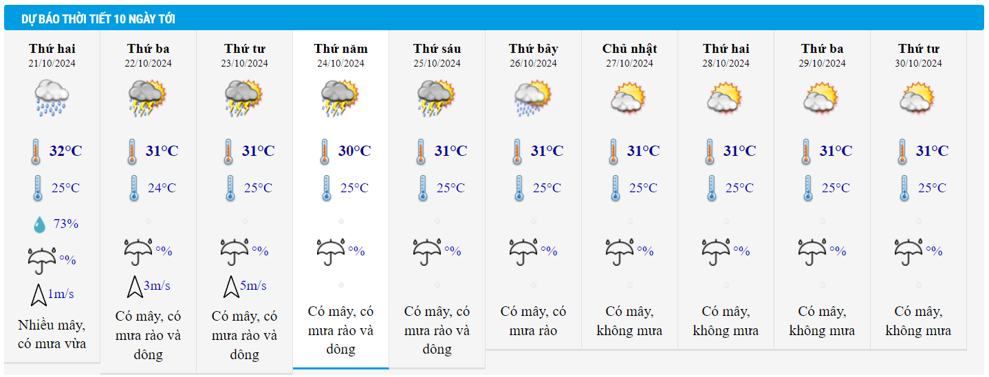
Weather forecast for October 21, 2024, Hanoi has showers and thunderstorms, east wind level 2-3, highest temperature 28-30 degrees. Areas from Thanh Hoa to Binh Dinh have very heavy rain with rainfall from 40-100mm, locally over 180mm.
According to the National Center for Hydro-Meteorological Forecasting, last night and early this morning (October 21), in some places in the Central and Southern regions, there was heavy to very heavy rain.
Rainfall from 7pm on October 20 to 3am on October 21 was over 90mm in some places such as: Do Luong (Nghe An) 111.4mm, Cam Son (Ha Tinh) 110.4mm, Quang Trach ( Quang Binh ) 96.8mm, Long Binh (Binh Phuoc) 106.6mm, Can Gio (Ho Chi Minh City) 103mm.
Weather forecast for today until the night of October 22, the area from Thanh Hoa to Binh Dinh will have moderate rain, heavy rain and scattered thunderstorms, locally very heavy rain with rainfall from 40-100mm, locally over 180mm. Warning of the risk of local heavy rain (>100mm/6 hours).
In addition, on the day and night of October 21, in the Northeast region, there will be scattered showers and thunderstorms, locally heavy rain with rainfall from 10-30mm, locally over 50mm.
On the afternoon and evening of October 21, in the Central Highlands, there will be scattered showers and thunderstorms, locally heavy rain with rainfall from 10-30mm, locally over 70mm. The Southern region will have rain, moderate rain and scattered thunderstorms, locally heavy to very heavy rain with rainfall of 20-40mm, some places over 80mm.
From October 23, in the area from Ha Tinh to Binh Dinh, there will be rain, moderate rain, locally heavy rain and thunderstorms with rainfall from 20-40mm, locally over 70mm.
Thunderstorms may produce tornadoes, lightning and strong gusts of wind.
The meteorological agency warned that heavy rain and localized heavy rain could cause flooding in low-lying areas; flash floods in small rivers and streams, and landslides on steep slopes.

Regarding weather at sea, the North East Sea area (including the sea area of Hoang Sa archipelago) has strong Northeast wind level 6, in the East sometimes level 7, gusting to level 8-9; rough sea, waves 3-5m high.
The western sea area of the North East Sea (including the waters of the Hoang Sa archipelago), the central and southern East Sea area (including the waters of the Truong Sa archipelago), the southern area of the Gulf of Tonkin, the sea area from Quang Tri to Quang Ngai, Binh Thuan to Ca Mau, Ca Mau to Kien Giang and the Gulf of Thailand will have scattered showers and thunderstorms. During thunderstorms, there is a possibility of tornadoes and strong gusts of wind of level 7-8.
All vessels operating in the above areas are at high risk of being affected by cyclones, strong winds and large waves.
In addition, experts from the National Center for Hydro-Meteorological Forecasting said that there is currently a cold air mass moving eastward, which will strengthen from October 22 to 23, then stabilize and weaken slowly.
From the night of October 21, a tropical convergence zone will form with an axis at about 9-12 degrees North latitude. On this tropical convergence zone, there is the possibility of forming a tropical cyclone.
Weather forecast for October 21, 2024 in detail for regions across the country:
Hanoi
Cloudy with occasional showers and thunderstorms. East wind force 2-3. Thunderstorms with possibility of tornadoes, lightning and strong gusts of wind.
Lowest temperature: 23-25 degrees.
Highest temperature: 28-30 degrees.
Northwest
Partly cloudy with scattered showers and thunderstorms. Light winds. Thunderstorms may produce tornadoes, lightning, and strong gusts of wind.
Lowest temperature: 22-25 degrees, some places below 21 degrees.
Highest temperature: 28-31 degrees, some places above 31 degrees
Northeast
Cloudy with scattered showers and thunderstorms, locally heavy rain. East to northeast wind level 2-3. Thunderstorms may produce tornadoes, lightning and strong gusts of wind.
Lowest temperature: 23-26 degrees, mountainous areas 21-24 degrees.
Highest temperature: 28-31 degrees, some places above 31 degrees.
Thanh Hoa - Thua Thien Hue
Cloudy with moderate to heavy rain and scattered thunderstorms, locally very heavy rain. Light wind. Thunderstorms may produce tornadoes, lightning and strong gusts of wind.
Lowest temperature: 22-25 degrees.
Highest temperature: 27-30 degrees.
Da Nang - Binh Thuan
In the North, it is cloudy with moderate to heavy rain and scattered thunderstorms, locally very heavy rain; in the South, it is cloudy with scattered showers and thunderstorms, especially in the afternoon and at night, scattered showers and thunderstorms, locally heavy rain. Wind from the North to the Northeast, level 2-3. During thunderstorms, there is a possibility of tornadoes, lightning and strong gusts of wind.
Lowest temperature: 23-26 degrees.
Highest temperature: North 28-30 degrees, South 31-33 degrees.
Central Highlands
Partly cloudy with scattered showers and thunderstorms, with scattered showers and thunderstorms in the afternoon and evening, with some heavy rain in some places. Light wind. Thunderstorms may produce tornadoes, lightning, and strong gusts of wind.
Lowest temperature: 19-22 degrees.
Highest temperature: 27-30 degrees, some places over 30 degrees.
Southern Vietnam
Cloudy with scattered showers and thunderstorms in the afternoon and evening, with scattered showers and thunderstorms, with heavy to very heavy rain in some places. Light wind. Thunderstorms may produce tornadoes, lightning, and strong gusts of wind.
Lowest temperature: 23-26 degrees.
Highest temperature: 30-33 degrees.
Weather in Ho Chi Minh City in the coming days:

Source: https://vietnamnet.vn/du-bao-thoi-tiet-21-10-2024-ha-noi-ha-nhiet-thanh-hoa-den-binh-dinh-mua-rat-to-2333757.html
![[Photo] Flooding on the right side of the gate, entrance to Hue Citadel](https://vphoto.vietnam.vn/thumb/1200x675/vietnam/resource/IMAGE/2025/10/28/1761660788143_ndo_br_gen-h-z7165069467254-74c71c36d0cb396744b678cec80552f0-2-jpg.webp)


![[Photo] Draft documents of the 14th Party Congress reach people at the Commune Cultural Post Offices](https://vphoto.vietnam.vn/thumb/1200x675/vietnam/resource/IMAGE/2025/10/28/1761642182616_du-thao-tai-tinh-hung-yen-4070-5235-jpg.webp)

![[Photo] National Assembly Chairman Tran Thanh Man received a delegation of the Social Democratic Party of Germany](https://vphoto.vietnam.vn/thumb/1200x675/vietnam/resource/IMAGE/2025/10/28/1761652150406_ndo_br_cover-3345-jpg.webp)


![[Photo] President Luong Cuong attends the 80th Anniversary of the Traditional Day of the Armed Forces of Military Region 3](https://vphoto.vietnam.vn/thumb/1200x675/vietnam/resource/IMAGE/2025/10/28/1761635584312_ndo_br_1-jpg.webp)


Comment (0)