Forecast of the time when storm Tra Mi is strongest
Báo Lao Động•24/10/2024
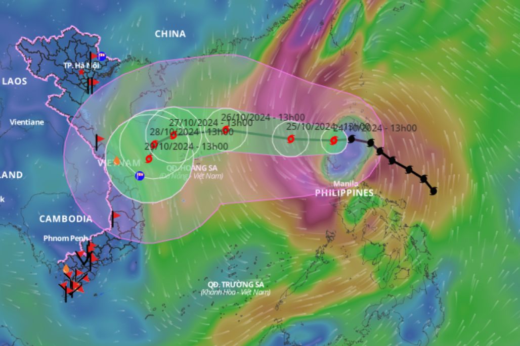
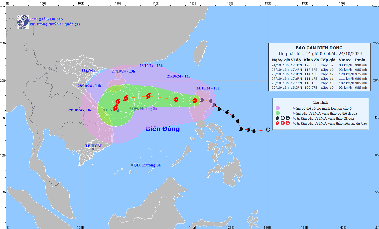
Storm Tra Mi is forecast to have a maximum intensity of level 11-12, gusting to level 15 when it is about 320km east-northeast of Hoang Sa archipelago.
Updated location and path of storm Tra Mi at 2:00 p.m. on October 24. Photo: Vietnam Disaster Monitoring System Latest update from the National Center for Hydro-Meteorological Forecasting, at 1:00 p.m. on October 24, storm Tra Mi's center was located at about 17.3 degrees north latitude; 120.3 degrees east longitude, on the mainland northwest of Luzon Island (Philippines). The strongest wind near the storm's center is level 9 (75-88 km/h), gusting to level 11. The storm is moving westward at a speed of 15-20 km/h. Updated location and path of storm Tra Mi at 2:00 p.m. on October 24. Photo: National Center for Hydro-Meteorological ForecastingIt is forecasted that in the next 24 hours , the storm will move west at a speed of about 10 - 15 km/h, entering the East Sea. At 13:00 on October 25, the center of the storm will be at about 17.4 degrees north latitude - 117.8 degrees east longitude; in the sea east of the North East Sea; 690 km east of the Hoang Sa archipelago. The strongest wind near the center of the storm will be at level 9 - 10, gusting to level 12. It is forecasted that in the next 48 hours , the storm will move west-northwest at a speed of about 15 - 20 km/h. At 13:00 on October 26, the center of the storm will be at about 17.9 degrees north latitude - 114.1 degrees east longitude; 320 km east-northeast of the Hoang Sa archipelago. The strongest wind near the storm center is level 11 - 12, gusting to level 15. It is forecasted that in the next 72 hours , the storm will move west at a speed of about 15km/h. At 1:00 p.m. on October 27, the storm center will be at about 17.6 degrees north latitude - 111.1 degrees east longitude; in the sea northwest of Hoang Sa archipelago. The strongest wind near the storm center is level 11, gusting to level 13.
Updated location and path of storm Tra Mi at 2:00 p.m. on October 24. Source: Vietnam Disaster Monitoring System
From the next 72 to 120 hours , the storm will move slowly in the west-southwest direction, traveling 5-10km per hour, and then it may change direction to the south-southwest. Regarding the impact of the storm, the sea area east of the North East Sea will have strong winds of level 6-7, then increase to level 8, the area near the storm's center will have winds of level 9-10 (89-102km/h), gusts of level 12, waves 3-5m high, the area near the storm's center will have waves of 5-7m; the sea is very rough. Ships operating in the above-mentioned dangerous areas are likely to be affected by storms, whirlwinds, strong winds, and large waves.


![[Photo] Prime Minister Pham Minh Chinh and Prime Minister of the Kingdom of Thailand Paetongtarn Shinawatra attend the Vietnam-Thailand Business Forum 2025](https://vphoto.vietnam.vn/thumb/1200x675/vietnam/resource/IMAGE/2025/5/16/1cdfce54d25c48a68ae6fb9204f2171a)


![[Photo] President Luong Cuong receives Prime Minister of the Kingdom of Thailand Paetongtarn Shinawatra](https://vphoto.vietnam.vn/thumb/1200x675/vietnam/resource/IMAGE/2025/5/16/52c73b27198a4e12bd6a903d1c218846)


Comment (0)