
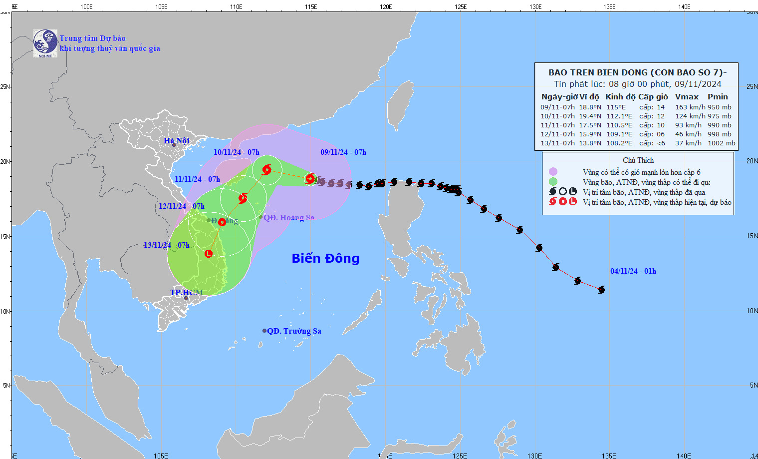
Latest storm update: At 10:00 AM (November 9th), the storm's center was located at approximately 18.9 degrees North latitude and 114.5 degrees East longitude, in the northern part of the South China Sea, about 415km northeast of the Hoang Sa (Paracel) Islands. The strongest winds near the storm's center reached level 14 (150-166 km/h), with gusts up to level 17.
Latest storm news: Forecast of the intensity of Typhoon Yinxing (Typhoon No. 7).
At 10:00 AM (November 9th), the typhoon's center was located at approximately 18.9 degrees North latitude and 114.5 degrees East longitude, in the northern part of the South China Sea, about 415km northeast of the Hoang Sa (Paracel) Islands. The strongest winds near the center of the typhoon reached level 14 (150-166 km/h), with gusts up to level 17. It was moving west-northwest at a speed of approximately 15 km/h.
Latest storm news: Forecast of the intensity of Typhoon No. 7 in the East Sea, when will it weaken into a tropical depression? Photo: NCHMF
Forecast of the development of Typhoon Yinxing (Typhoon No. 7) over the next 24 to 72 hours.
Forecast time | Direction, speed | Location | Intensity | Hazardous area | Level of natural disaster risk (Affected area) |
10:00 AM on 10/11 | West-Northwest, 10-15km/h | 19.1N-112.1E; in the northwestern sea area the northern South China Sea area, about 290km north of the Paracel Islands. | Level 12-13, gusts up to level 16. | Latitude 16.0N-21.5N; Longitude 109.5E-114.0E | High school: The northern South China Sea area (including the waters around the Paracel Islands); specifically the area from latitude 17.0N-21.0N; longitude 110.0E-114.0E level 4 |
10:00 AM on November 11th | Southwest, approximately 10-15 km/h, gradually weakening. | 17.4N-110.5E; approximately 160km northwest of the Paracel Islands. | Level 10, then level 13 | Latitude 15.0N-21.0N; Longitude 109.0E-114.0E | High school: side Western part of the North East Sea (including the waters around the Paracel Islands) |
10:00 AM, 12/11 | Southwest approximately 15 km/h and gradually weakened into a tropical depression, then a low-pressure area. | 14.8N-108.6E; on land provinces from Quang Nam to Binh Dinh |
Over the next 72 to 96 hours, the tropical depression moved southwest at approximately 10 km per hour and weakened into a low-pressure area.
Regarding the impact of Typhoon Yinxing (Typhoon No. 7)
In the northern South China Sea, winds will be strong, reaching levels 8-11, and levels 12-14 near the storm's center, with gusts up to level 17. Sea waves will be 4.0-6.0m high, and 7.0-9.0m near the center; the sea will be extremely rough.
Vessels operating in the aforementioned hazardous areas are susceptible to the effects of thunderstorms, tornadoes, strong winds, and high waves.
Yesterday afternoon (November 8th), at a meeting between ministries, departments, and relevant units to focus on measures to respond to Typhoon No. 7, Mr. Mai Van Khiem, Director of the National Center for Meteorological and Hydrological Forecasting, stated that the subtropical high pressure system combined with cold air will "control" the typhoon's movement northward.
Specifically, during today, Typhoon No. 7 will maintain its strongest intensity, then gradually weaken due to the influence of cold air, dry air, and low humidity. The direction of Typhoon No. 7 is influenced by the environmental currents caused by the subtropical high-pressure system, making it difficult for the typhoon to move northward. Upon entering the northern part of the Hoang Sa archipelago, the typhoon will change direction to west-southwest, heading towards the central coast of Vietnam.
Due to the influence of the storm, the northern South China Sea area will experience strong winds of force 8-11, reaching force 12-14 near the storm's center, with gusts up to force 17. Sea waves will be 4-6 meters high, and 7-9 meters near the storm's center, resulting in extremely rough seas. Vessels operating in these dangerous areas are at risk of being affected by thunderstorms, tornadoes, strong winds, and high waves.
Source: https://danviet.vn/tin-bao-moi-nhat-du-bao-cuong-do-cua-bao-so-7-o-bien-dong-khi-nao-suy-yeu-thanh-ap-thap-nhiet-doi-20241109111318468.htm


![[Image] Close-up of the newly discovered "sacred road" at My Son Sanctuary](/_next/image?url=https%3A%2F%2Fvphoto.vietnam.vn%2Fthumb%2F1200x675%2Fvietnam%2Fresource%2FIMAGE%2F2025%2F12%2F13%2F1765587881240_ndo_br_ms5-jpg.webp&w=3840&q=75)


Comment (0)